


Kilimanjaro National Park was established in 1973. It initially comprised the parts of the mountain above the tree line as well as six trails descending through the rainforest.
Now, the park covers the mountain in its entirety from 6,000 feet high to the summit.
What are the Main Kilimanjaro Routes?
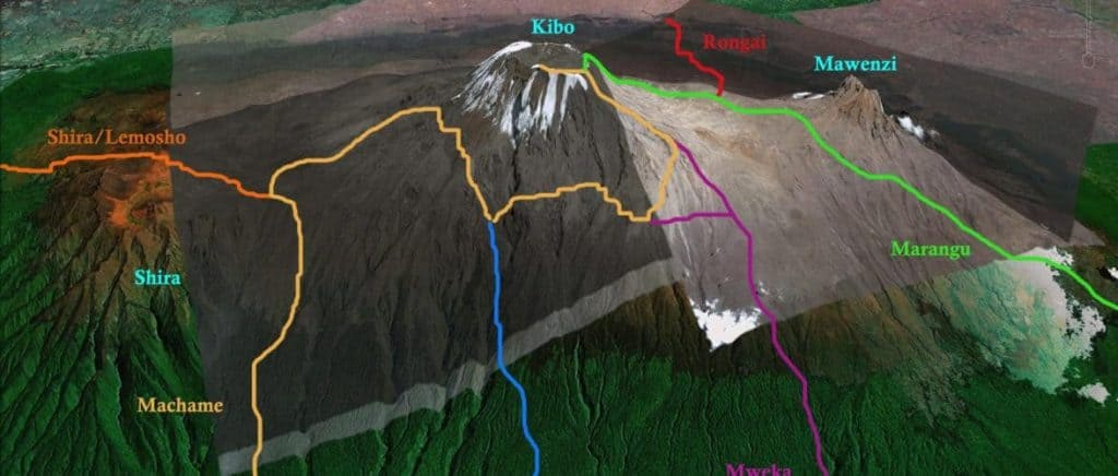
There are seven established routes for climbing Kilimanjaro. There are also different variations of these routes, in the number of days spent on the mountain and in the campsites used.
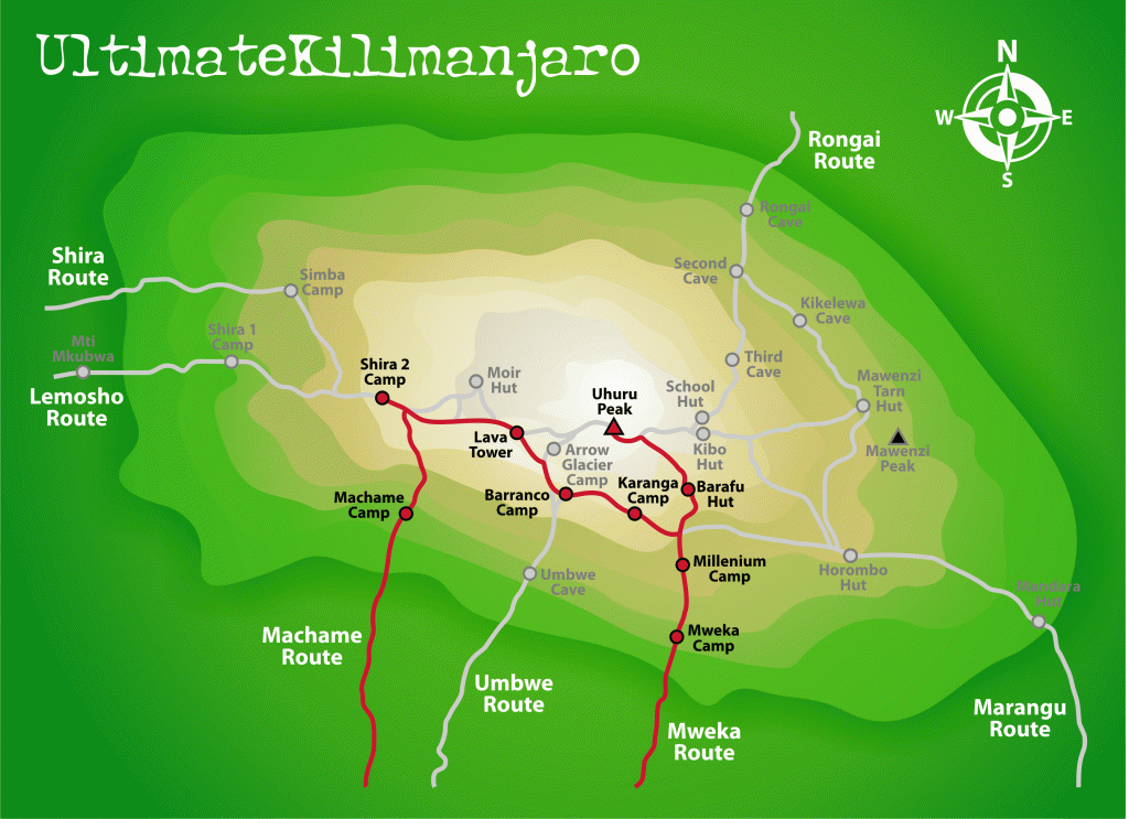
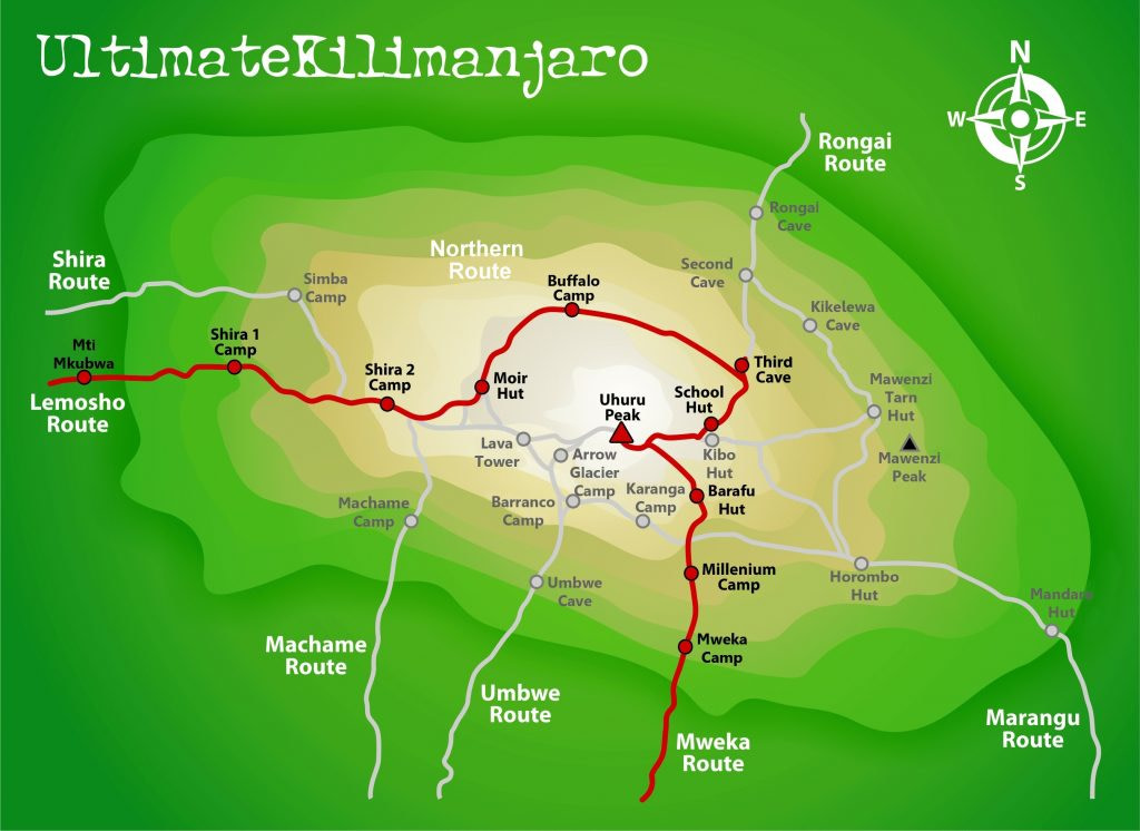
Below is a Kilimanjaro map from Google Earth. The main routes are listed and color coded.
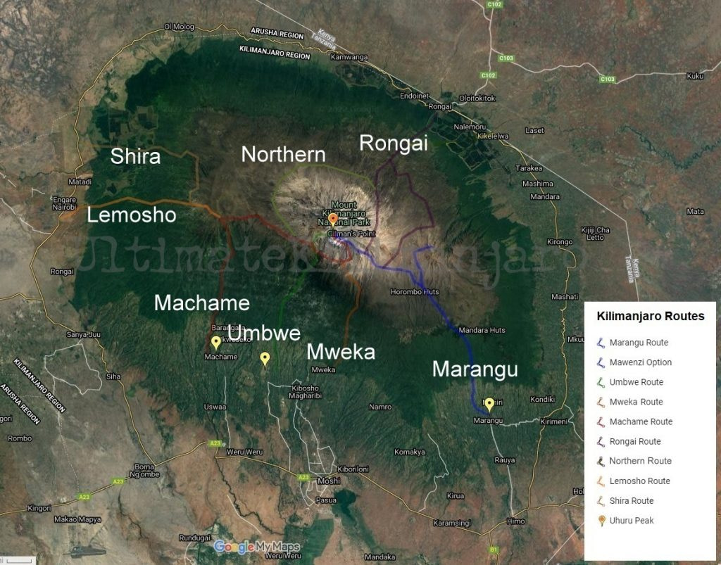
The routes used for ascent are:
- Marangu Route (aka Coca-Cola Route or Tourist Route)
- Machame Route (aka Whiskey Route)
- Umbwe Route
- Rongai Route
- Shira Route (aka Shira Plateau Route)
- Lemosho Route
- Northern Circuit Route
Note that the park authorities dictate the route used for descent, depending on the route used to climb. In other words, you are not free to choose your own descent path.
The routes used for descent are:
- Mweka Route
- Marangu Route
Which Approach is Better for Climbing Kilimanjaro?
The direction you approach the mountain will affect the scenery.
First, we have to discuss the geology. Mount Kilimanjaro is a dormant volcano, or rather a series of three volcanoes – Shira, Mawenzi, and Kibo. These volcanoes began to form during the creation of the Great Rift Valley around a million years ago.
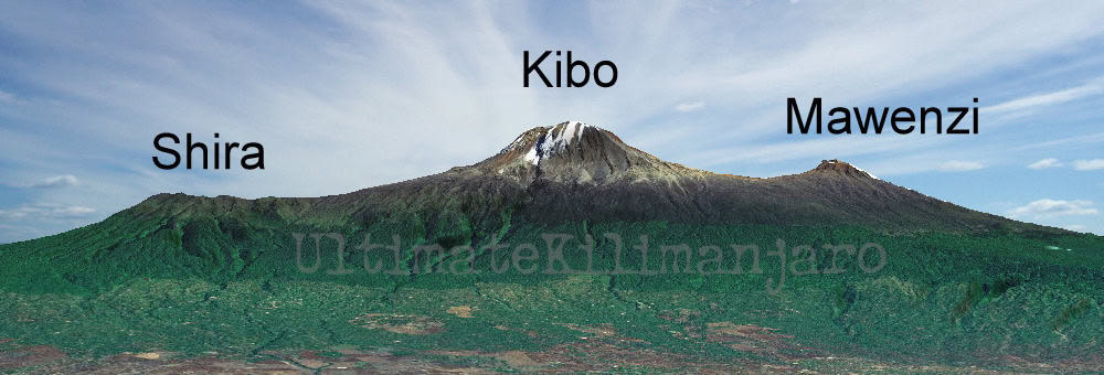
Shira was the first to form. But about 500,000 years ago, it caved in to form a caldera (a depression when a volcano erupts and collapses). Mawenzi began to form about 460,000 years ago. Then Kibo, the youngest and highest, was formed.
Shira lies northwest of the summit, while Mawenzi lies southeast of the summit. Therefore, any route that approaches from the west will cross the Shira Plateau. Routes that approach from the east will have close up views of Mawenzi peak (though you will be able to see Mawenzi from every route).
Subjectively, the routes that approach from the west – Shira, Lemosho, Northern Circuit and Machame – are considered to be prettier. And objectively, the routes that approach from the west are generally longer routes and therefore have higher success rates due to better acclimatization.
See 15 Amazing Sights to See While Climbing Kilimanjaro.
What are the Most Popular Routes for Climbing Kilimanjaro?
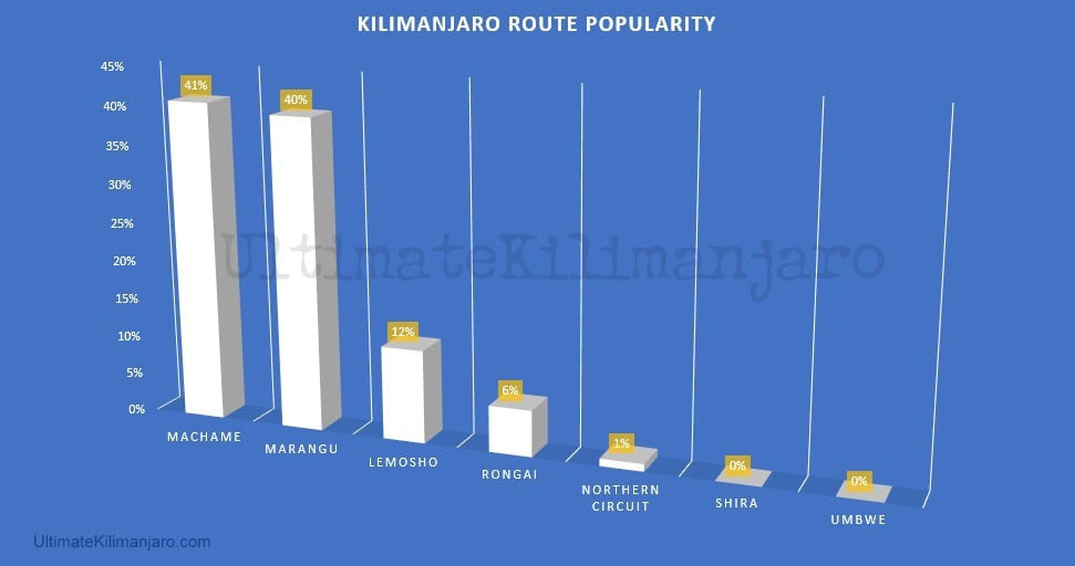
It is estimated that:
- 41% of climbers use the Machame route.
- 40% of climbers use the Marangu route.
- 12% of climbers use the Lemosho route.
- 6% of climbers use the Rongai route.
- 1% of climbers use the Northern Circuit route
- 0% of climbers use the Shira route.
- 0% of climbers use the Umbwe route.
We do not recommend the most popular routes.
What Kilimanjaro Routes Do You Recommend?
While most companies had guided exclusively on Machame and Marangu in the past, we have always steered away from these trails. We preferred routes with the most favorable combination of high success rates, excellent scenery, and low foot traffic.
We guided primarily on Lemosho, then later Northern Circuit (we were one of the first to offer group climbs on this newer route). These are our current favorite routes and we highly recommend using one of these for your climb. These are the best Kilimanjaro routes.
Ultimate Kilimanjaro® clients use Lemosho (69%), Northern Circuit (19%), Rongai (6%), Machame (6%).
What are the Biggest Differences Between the Routes?
Below are individual maps of each Kilimanjaro route and short route descriptions.
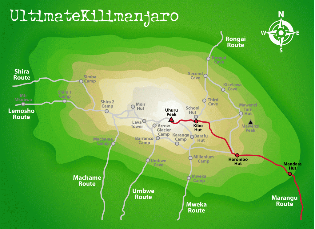
Marangu Route: (GENERALLY NOT RECOMMENDED) Popular tourist route. Approaches from southeast. Easy, gentle gradients. Beautiful rainforest section and moorlands. Comfortable but basic hut shelter. Good choice during rainy season. Poor acclimatization profile. Less scenic due to descent on same trail. 82 km, 5-6 days.
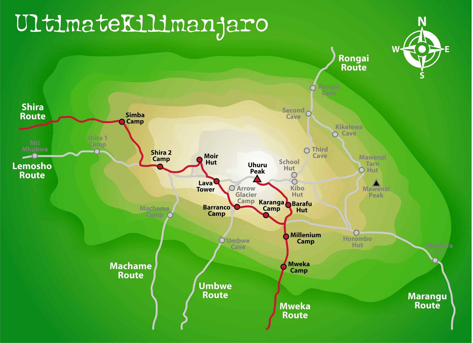
Machame Route (RECOMMENDED ROUTE): Most popular route. Approaches from south. Short access drive to trailhead. Very scenic route with southern traverse. Difficult up/down path, but very good for acclimatization. Best short route. Camping. 62 km, 6-7 days.
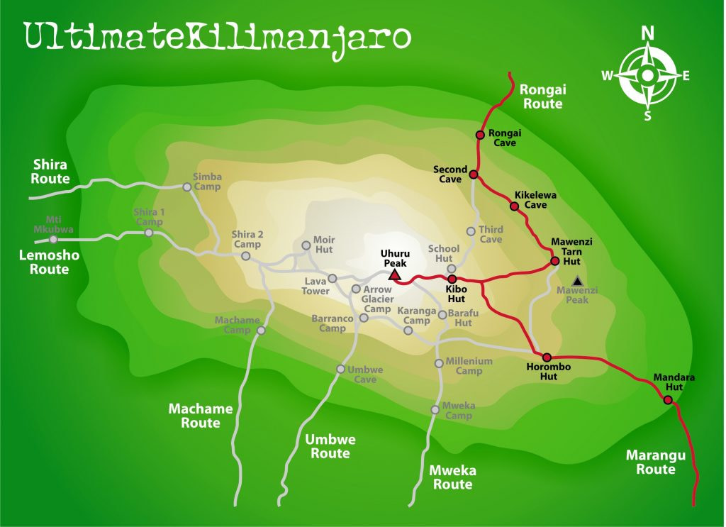
Rongai Route (RECOMMENDED ROUTE): Long access drive to trailhead. Approaches from north. Remote, less frequented. Easy, gentle gradients. Preferred alternative to Marangu. Beautiful alpine desert section. Good during rainy season. Camping. Fair acclimatization profile. 79 kms, 6-7 days.
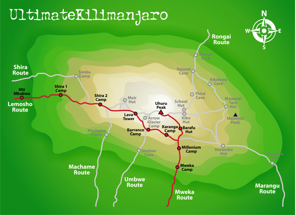
Lemosho Route (HIGHLY RECOMMENDED): Long access drive to trailhead. Approaches from west. Remote, less frequented. Beautiful heath section. Very scenic with southern traverse. Camping. Difficult up/down path but excellent for acclimatization. 70 km, 6-8 days.
Shira Route (GENERALLY NOT RECOMMENDED): Almost same as Lemosho route. Approaches from west. Long access drive to trailhead. Trail starts at 11,800 feet. Remote, less frequented. Beautiful heath section. Very scenic with southern traverse. Camping. Difficult up/down path. Poor acclimatization in beginning due to high starting elevation, but good afterwards. 56 km, 6-8 days.
Northern Circuit Route (HIGHLY RECOMMENDED) : Newest route. Very few climbers on north side. Approaches from west. Very scenic with northern traverse. Nearly 360 degree views. Difficult up/down path in beginning but mostly flat in middle. Best route for acclimatization. Longest route. Camping. 98 km, 9 days.
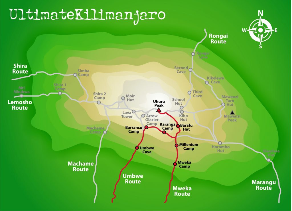
Umbwe Route (GENERALLY NOT RECOMMENDED): Least used trail. Approaches from south. Shortest and steepest route. Spectacular ridge. Scenic with southern traverse. Difficult route with poor acclimatization profile due to speed of ascent. Pre-acclimatization is recommended. Camping. 53km, 6-7 days.
Where Do Kilimanjaro Climbs Begin?
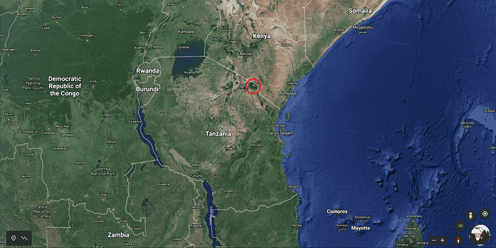
Mount Kilimanjaro lies within the northern border of Tanzania, close to Kenya. The red circle in the map below shows the location of the mountain.
There are two gateway cities to Kilimanjaro – Arusha and Moshi.
Our trips typically begin in Moshi though we do stage clients in Arusha for safaris as well.
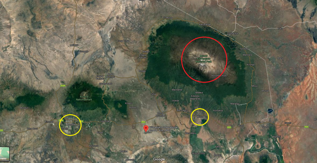
Kilimanjaro International Airport (airport code: JRO) is close to Moshi and Arusha. It takes about 40 minutes by vehicle to travel from the airport to either city.
The drive from Moshi to the western and northern trailheads take approximately one hour, while the drive to the southern trailheads are closer and thereby shorter.

")


