
The Rongai route is the only route that approaches Kilimanjaro from the north, close to the Kenyan border. Though gaining popularity amongst climbers, this route still experiences low crowds.
Rongai has a more gradual slope than the mountain’s other routes. It is the preferred route for those looking for an alternative to the popular Marangu route, for those who would like a more remote hike, and for those who are climbing during the rainy season (the north side receives less precipitation).
Rongai is a moderately difficult route and is highly recommended, especially for those with less backpacking experience.
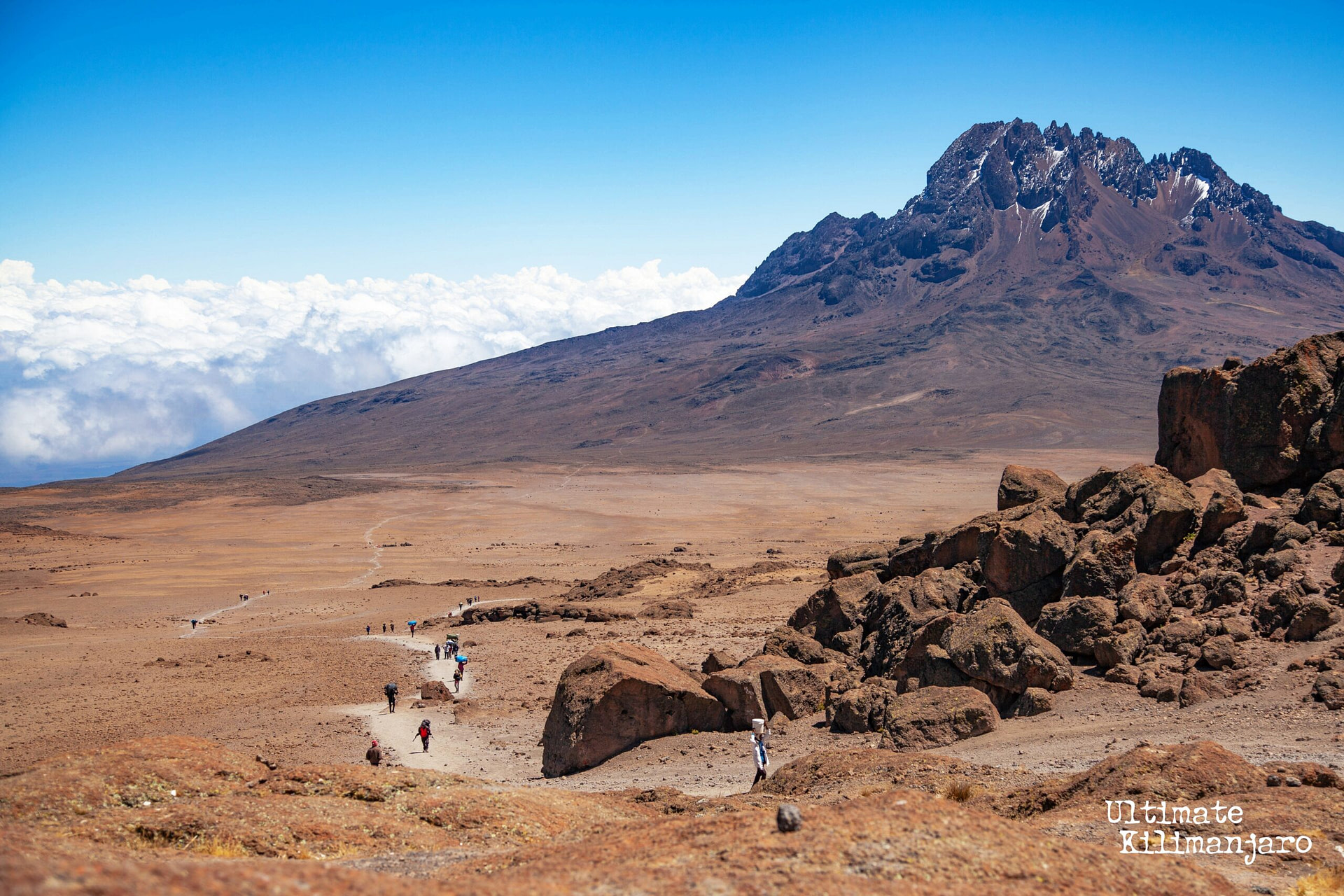
Although the scenery is not as varied as the western routes, Rongai makes up for this by passing through true wilderness areas for nearly the entire way. Descent is made via the Marangu route.
Ultimate Kilimanjaro® offers Rongai as a private climb, with itinerary variations ranging from 6 to 8 days.
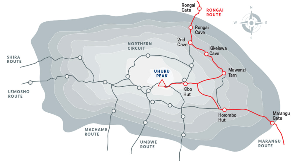
7 DAY RONGAI (STANDARD ROUTE)
The 7-Day Rongai is the standard itinerary and our recommended version of this route. It offers a steady approach and a dedicated acclimatization day on day four.
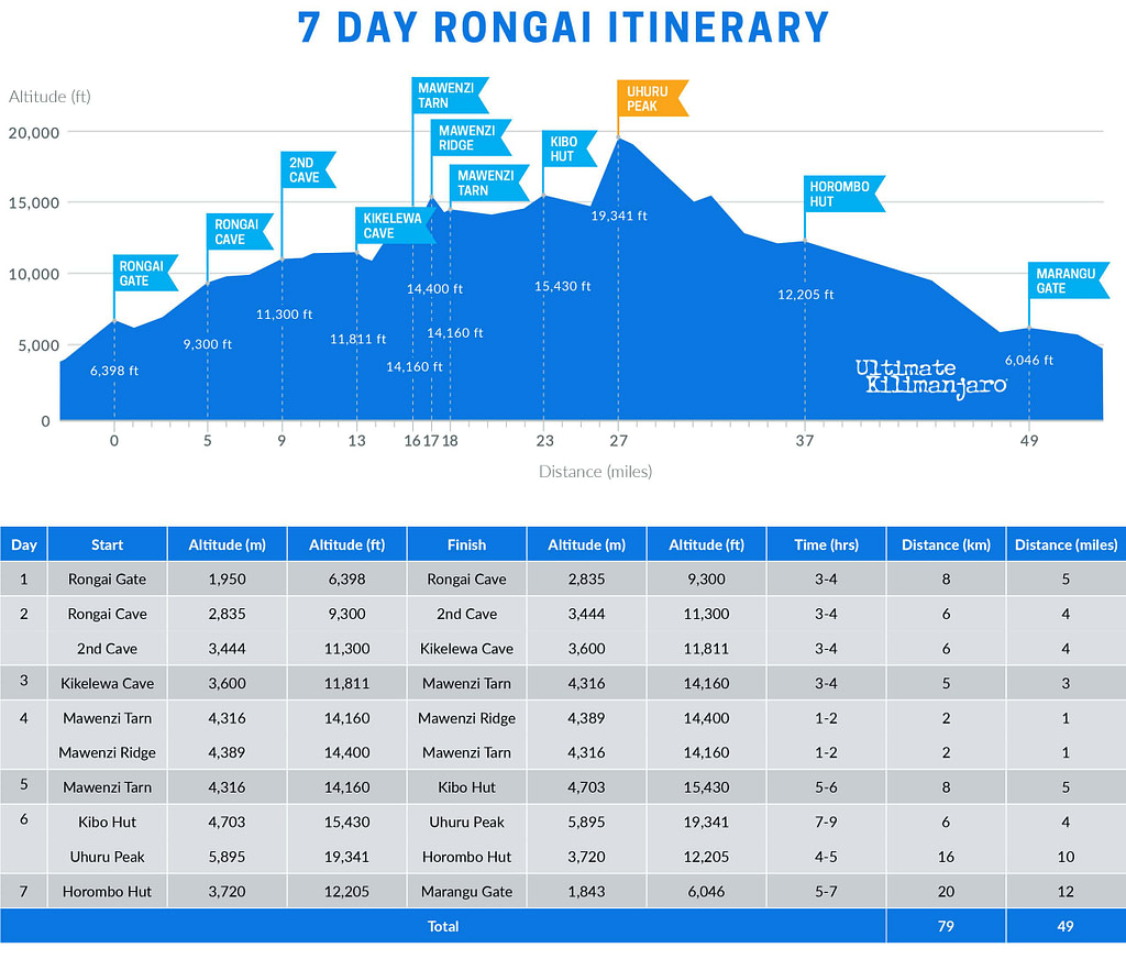
DAY 1 – Rongai Gate to Rongai Cave
Elevation: 6,398 ft to 9,300 ft
Hiking Time: 3-4 hours
Distance: 8 km | 5 miles
Habitat: Rain Forest
We drive from Moshi to Marangu Gate for permits before taking a short transfer to the Rongai Gate trailhead. The path winds through corn and potato fields and then climbs gently through the forest which is home to a variety of wildlife, including the black and white colobus monkey.
DAY 2 – Rongai Cave to Second Cave to Kikelewa Cave
Rongai Cave to to Second Cave
Elevation: 9,300 ft to 11,300 ft
Hiking Time: 3-4 hours
Second Cave to Kikelewa Cave
Elevation: 11,300 ft to 11,811 ft
Hiking Time: 3-4 hours
.
Distance: 6 km | 4 miles
Habitat: Heath
.
Distance: 6 km | 4 miles
Habitat: Heath
We begin this morning with a steady incline up to Second Cave. We continue trekking though moorland, leaving the main trail for a smaller path towards the jagged peaks of Mawenzi, before finally arriving at Kikelewa Cave for the night.
DAY 3 – Kikelewa Cave to Mawenzi Tarn
Elevation: 11,811 ft to 14,160 ft
Hiking Time: 3-4 hours
Distance: 5 km | 3 miles
Habitat: Alpine Desert
The hike today is short and steep up a grassy slope. Views of the wilderness area are stunning. As we exit the heath zone and emerge into the Alpine Desert zone, the landscape changes dramatically. Our camp is situated beneath the jagged spires of Mawenzi, at Mawenzi Tarn. The remainder of the day can be spent relaxing or exploring the area.
DAY 4 – Mawenzi Tarn to Mawenzi Ridge to Mawenzi Tarn
Mawenzi Tarn to Mawenzi Ridge
Elevation: 14,160 ft -14,400 ft
Hiking Time: 1-2 hours
Mawenzi Ridge to Mawenzi Tarn
Elevation: 14,400 ft -14,160 ft
Hiking Time: 1-2 hours
.
Distance: 2 km | 1 miles
Habitat: Alpine Desert
.
Distance: 2 km | 1 miles
Habitat: Alpine Desert
This is an extra day meant for acclimatization and can be spent day hiking on Mawenzi Ridge. The unique landscape offers motivating views of Kibo and Mawenzi. After spending a few moments exploring the area we head back to Mawenzi Tarn for camp.
DAY 5 – Mawenzi Tarn to Kibo Hut
Elevation: 14,160 ft to 15,430 ft
Hiking Time: 5-6 hours
Distance: 8 km | 5 miles
Habitat: Alpine Desert
We climb gradually, then cross the lunar desert of the “Saddle” between Mawenzi and Kibo. Our camp, Kibo Hut, sits at the bottom of the Kibo crater wall. Once here we rest, enjoy an early dinner to prepare for the summit day.
DAY 6 – Kibo Hut to Uhuru Peak to Horombo Hut
School Hut to Uhuru Peak
Elevation: 15,430 ft to 19,341 ft
Hiking Time: 7-9 hours
Uhuru Peak to Horombo Hut
Elevation: 19,341 ft to 12,205 ft
Hiking Time: 4-6 hours
.
Distance: 6 km | 4 miles
Habitat: Arctic
.
Distance: 16 km | 10 miles
Habitat: Heath
Very early in the morning (around midnight), we begin our push to the summit. This is the most mentally and physically challenging portion of the trek. The wind and cold at this elevation and time of day can be extreme. We ascend in the darkness for several hours while taking frequent, but short, breaks. At Gilman’s point (18,600 ft), you will be rewarded with the most magnificent sunrise you are ever likely to see coming over Mawenzi Peak. Finally, we arrive at Uhuru Peak- the highest point on Mount Kilimanjaro and the continent of Africa.
After spending a few moments taking in the plains of Africa and your accomplishment, we descend to Horombo Hut. Later in the evening, we enjoy our last dinner on the mountain and a well-earned sleep.
DAY 7 – Horombo Hut to Marangu Gate
Elevation: 12,205 ft to 6,046 ft
Hiking Time: 7-9 hours
Distance: 20 km | 12 miles
Habitat: Rain Forest
On our last day, we have a long trek mostly downhill through the tropical rainforest. Once at the park headquarters at Marangu gate, we collect our summit certificates. A vehicle will meet us here and drive us back to the hotel in Moshi.
8 DAY RONGAI (DAYTIME SUMMIT)
The 8-Day Rongai (Daytime Summit) variation follows the 7-day Rongai route, but replaces the traditional midnight summit with a daytime ascent. It avoids the extreme cold and windy nighttime conditions, while also shortening the duration of summit day. Thus, summit day is more comfortable and less physically demanding.
After summiting, climbers return to Kibo Hut instead of descending directly to Horombo Hut. This easier-paced descent adds one day to the itinerary.
Read more about Daytime Summit Routes.
DAY 1 – Rongai Gate to Rongai Cave
Elevation: 6,398 ft to 9,300 ft
Hiking Time: 3-4 hours
Distance: 8 km | 5 miles
Habitat: Rain Forest
We drive from Moshi to Marangu Gate for permits before taking a short transfer to the Rongai Gate trailhead. The path winds through corn and potato fields and then climbs gently through the forest which is home to a variety of wildlife, including the black and white colobus monkey.
DAY 2 – Rongai Cave to Second Cave to Kikelewa Cave
Rongai Cave to to Second Cave
Elevation: 9,300 ft to 11,300 ft
Hiking Time: 3-4 hours
Second Cave to Kikelewa Cave
Elevation: 11,300 ft to 11,811 ft
Hiking Time: 3-4 hours
.
Distance: 6 km | 4 miles
Habitat: Heath
.
Distance: 6 km | 4 miles
Habitat: Heath
We begin this morning with a steady incline up to Second Cave. We continue trekking though moorland, leaving the main trail for a smaller path towards the jagged peaks of Mawenzi, before finally arriving at Kikelewa Cave for the night.
DAY 3 – Kikelewa Cave to Mawenzi Tarn
Elevation: 11,811 ft to 14,160 ft
Hiking Time: 3-4 hours
Distance: 5 km | 3 miles
Habitat: Alpine Desert
The hike today is short and steep up a grassy slope. Views of the wilderness area are stunning. As we exit the heath zone and emerge into the Alpine Desert zone, the landscape changes dramatically. Our camp is situated beneath the jagged spires of Mawenzi, at Mawenzi Tarn. The remainder of the day can be spent relaxing or exploring the area.
DAY 4 – Mawenzi Tarn to Mawenzi Ridge to Mawenzi Tarn
Mawenzi Tarn to Mawenzi Ridge
Elevation: 14,160 ft -14,400 ft
Hiking Time: 1-2 hours
Mawenzi Ridge to Mawenzi Tarn
Elevation: 14,400 ft -14,160 ft
Hiking Time: 1-2 hours
.
Distance: 2 km | 1 miles
Habitat: Alpine Desert
.
Distance: 2 km | 1 miles
Habitat: Alpine Desert
This is an extra day meant for acclimatization and can be spent day hiking on Mawenzi Ridge. The unique landscape offers motivating views of Kibo and Mawenzi. After spending a few moments exploring the area we head back to Mawenzi Tarn for camp.
DAY 5 – Mawenzi Tarn to Kibo Hut
Elevation: 14,160 ft to 15,430 ft
Hiking Time: 5-6 hours
Distance: 8 km | 5 miles
Habitat: Alpine Desert
We climb gradually, then cross the lunar desert of the “Saddle” between Mawenzi and Kibo. Our camp, Kibo Hut, sits at the bottom of the Kibo crater wall. Once here we rest, enjoy an early dinner to prepare for the summit day.
DAY 6 – Kibo Hut to Uhuru Peak to Kibo Hut
Kibo Hut to Uhuru Peak
Elevation: 15,430 ft to 19,341 ft
Hiking Time: 7-9 hours
Uhuru Peak to Kibo Hut
Elevation: 19,341 ft to 15,430 ft
Hiking Time: 2-3 hours
.
Distance: 6 km | 4 miles
Habitat: Arctic
.
Distance: 6 km | 4 miles
Habitat: Heath
In the morning light, we begin our push to the summit. This is the most mentally and physically challenging portion of the trek. We ascend for several hours while taking frequent, but short, breaks. Upon reaching the crater rim, you arrive at Gilman’s point (18,600 ft), with the summit within striking distance. Finally, we arrive at Uhuru Peak – the highest point on Mount Kilimanjaro and the continent of Africa.
From the summit, we return to Kibo Hut, where we celebrate our achievement and enjoy a well-earned sleep.
DAY 7 – Kibo Hut to Horombo Hut
Elevation: 15,430 ft to 12,205 ft
Hiking Time: 2-3 hours
Distance: 10 km | 6 miles
Habitat: Heath
We make our descent on a gentle path down to Horombo Hut, which is situated in the moorland zone. Later in the evening, we have our last dinner on the mountain.
DAY 8 – Horombo Hut to Marangu Gate
Elevation: 12,205 ft to 6,046 ft
Hiking Time: 5-7 hours
Distance: 20 km | 12 miles
Habitat: Rain Forest
On our last day, we have a long trek mostly downhill through the tropical rainforest. Once at the park headquarters at Marangu gate, we collect our summit certificates. A vehicle will meet us here and drive us back to the hotel in Moshi.
6 DAY RONGAI
The 6-Day Rongai is a shortened variation of the standard itinerary. It combines the trek from Rongai Cave to Kikelewa Camp into a single day, removing the acclimatization day at Mawenzi Tarn. This results in a faster ascent and is best suited for experienced trekkers.
DAY 1 – Rongai Gate to Rongai Cave
Elevation: 6,398 ft to 9,300 ft
Hiking Time: 3-4 hours
Distance: 8 km | 5 miles
Habitat: Rain Forest
We drive from Moshi to Marangu Gate for permits before taking a short transfer to the Rongai Gate trailhead. The path winds through corn and potato fields and then climbs gently through the forest which is home to a variety of wildlife, including the black and white colobus monkey.
DAY 2 – Rongai Cave to Second Cave to Kikelewa Cave
Rongai Cave to Second Cave
Elevation: 9,300 ft to 11,300 ft
Hiking Time: 3-4 hours
Second Cave to Kikelewa Cave
Elevation: 11,300 ft to 11,811 ft
Hiking Time: 3-4 hours
.
Distance: 6 km | 4 miles
Habitat: Heath
.
Distance: 6 km | 4 miles
Habitat: Heath
We begin this morning with a steady incline up to Second Cave. We continue trekking though moorland, leaving the main trail for a smaller path towards the jagged peaks of Mawenzi, before finally arriving at Kikelewa Cave for the night.
DAY 3 – Kikelewa Cave to Mawenzi Tarn
Elevation: 11,811 ft to 14,160 ft
Hiking Time: 3-4 hours
Distance: 5 km | 3 miles
Habitat: Alpine Desert
The hike today is short and steep up a grassy slope. Views of the wilderness area are stunning. As we exit the heath zone and emerge into the Alpine Desert zone, the landscape changes dramatically. Our camp is situated beneath the jagged spires of Mawenzi, at Mawenzi Tarn. The remainder of the day can be spent relaxing or exploring the area.
DAY 4 – Mawenzi Tarn to Kibo Hut
Elevation: 14,160 ft to 15,430 ft
Hiking Time: 5-6 hours
Distance: 8 km | 5 miles
Habitat: Alpine Desert
We climb gradually, then cross the lunar desert of the “Saddle” between Mawenzi and Kibo. Our camp, Kibo Hut, sits at the bottom of the Kibo crater wall. Once here we rest, enjoy an early dinner to prepare for the summit day.
DAY 5 – Kibo Hut to Uhuru Peak to Horombo Hut
Kibo Hut to Uhuru Peak
Elevation: 15,430 ft to 19,341 ft
Hiking Time: 7-9 hours
Uhuru Peak to Horombo Hut
Elevation: 19,341 ft to 12,205 ft
Hiking Time: 4-6 hours
.
Distance: 6 km | 4 miles
Habitat: Arctic
.
Distance: 16 km | 10 miles
Habitat: Heath
Very early in the morning (around midnight), we begin our push to the summit. This is the most mentally and physically challenging portion of the trek. The wind and cold at this elevation and time of day can be extreme. We ascend in the darkness for several hours while taking frequent, but short, breaks. At Gilman’s point (18,600 ft), you will be rewarded with the most magnificent sunrise you are ever likely to see coming over Mawenzi Peak. Finally, we arrive at Uhuru Peak- the highest point on Mount Kilimanjaro and the continent of Africa.
After spending a few moments taking in the plains of Africa and your accomplishment, we descend to Horombo Hut. Later in the evening, we enjoy our last dinner on the mountain and a well-earned sleep.
DAY 6 – Horombo Hut to Marangu Gate
Elevation: 12,205 ft to 6,046 ft
Hiking Time: 7-9 hours
Distance: 20 km | 12 miles
Habitat: Rain Forest
On our last day, we have a long trek mostly downhill through the tropical rainforest. Once at the park headquarters at Marangu gate, we collect our summit certificates. A vehicle will meet us here and drive us back to the hotel in Moshi.
ROUTE FAQs
How Long is the Rongai Route?
The distance of the Rongai route is approximately 81 km or 50 miles.
How Many Days Does it Take to Climb Kilimanjaro on the Rongai Route?
The Rongai route has several variations and can be completed in 6 to 8 days. The standard itinerary is the preferred variation which requires 7 days.
How Hard is it to Climb Kilimanjaro on the Rongai Route?
The Rongai route is considered a moderate route. The elevation gain is gradual and not strenuous. However, because it is one of Kilimanjaro’s shorter routes, some climbers may succumb to altitude sickness due to its less than ideal route profile.
What is the Success Rate of Climbing Kilimanjaro on the Rongai Route?
For all operators combined, it is estimated that the 6 day Rongai route has a success rate of approximately 50% and the 7 day Rongai route has a success rate of about 70%. Our 6 day Rongai route has a success rate of approximately 70-75% and our 7 and 8 day Rongai route has a success rate of approximately 85-90%.
How Much Does it Cost to Climb Kilimanjaro on the Rongai Route?
The cost of the Rongai route will vary depending on the guide service. See our prices here.