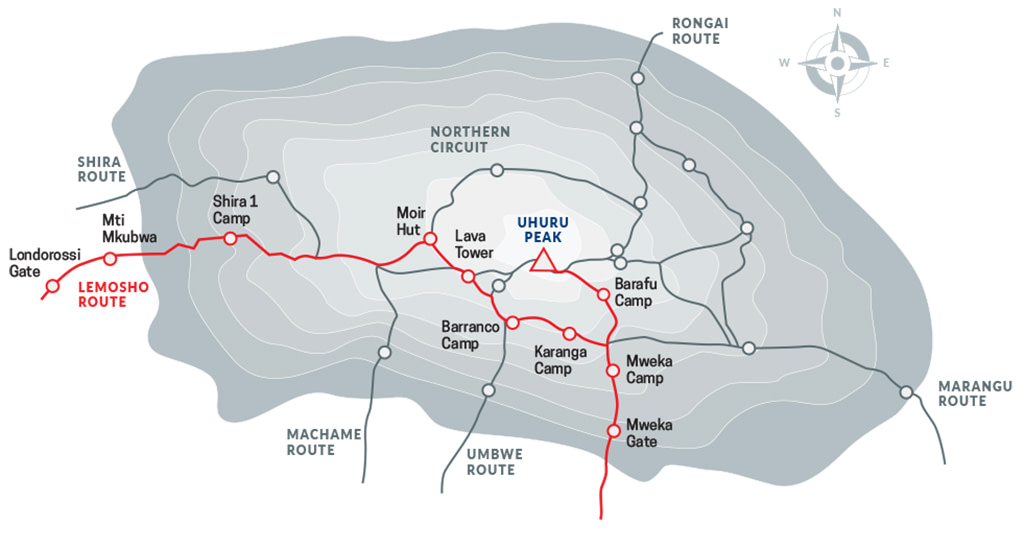
The Lemosho route is considered the most scenic trail on Kilimanjaro, granting panoramic vistas on various sides of the mountain.
As one of the newer Kilimanjaro routes, Lemosho is a superb choice for your climb. It is our preferred route due to its ideal balance of low crowds, beautiful scenery and a high summit success rate.
Ultimate Kilimanjaro® specializes in guiding on the Lemosho route. Most of our clients climb Kilimanjaro using this route and they consistently report that they loved it. Thus, Lemosho is highly recommended.
The route approaches Mount Kilimanjaro from the west, beginning with a long drive from Moshi to Londorossi Gate. From there, the first two days are spent trekking through the rain forest to Shira Ridge. The Lemosho route crosses the entire Shira Plateau from west to east in a pleasant, relatively flat hike. Crowds are low until the route joins the Machame route near Lava Tower. Then the route traverses underneath Kilimanjaro’s Southern Ice Field on a path known as the Southern Circuit before summiting from Barafu. Descent is made via the Mweka route.
Ultimate Kilimanjaro® offers Lemosho as an 8 to 9 day group climb or as a 7 to 9 day private climb.
8 DAY LEMOSHO (STANDARD ROUTE)
The 8-Day Lemosho Route is the standard itinerary and by far our most popular route. It is widely considered to have the mountain’s optimal balance of low crowds, excellent acclimatization, and diverse scenery. By spreading the trek over eight days, climbers enjoy a steady, manageable pace.
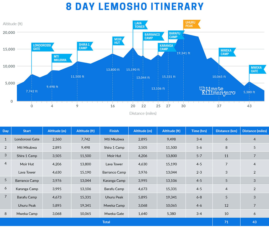
DAY 1 – Londorossi Gate to Mti Mkubwa
Elevation: 7,742 ft to 9,498 ft
Hiking Time: 3-4 hours
Distance: 6 km | 4 miles
Habitat: Rain Forest
We depart Moshi for Londorossi Gate, which takes about 4 hours, where you will complete entry formalities. Then drive to the Lemosho trailhead. Upon arrival at trailhead, we begin hiking through undisturbed forest which winds to the first camp site.
DAY 2 – Mti Mkubwa to Shira 1 Camp
Elevation: 9,498 ft to 11,500 ft
Hiking Time: 5-6 hours
Distance: 8 km | 5 miles
Habitat: Heath
We continue on the trail leading out of the rain forest and into a savannah of tall grasses, heather and volcanic rock draped with lichen beards. As we ascend through the lush rolling hills and cross several streams, we reach the Shira Ridge before dropping gently down to Shira 1 Camp. Here we catch our first glimpse of Kibo across the plateau.
DAY 3 – Shira 1 Camp to Moir Hut
Elevation: 11,500 ft to 13,800 ft
Hiking Time: 5-7 hours
Distance: 11 km | 7 miles
Habitat: Heath
We explore the Shira Plateau for a full day. It is a gentle walk east on moorland meadows towards Shira 2 Camp. Then we divert from the main trail to Moir Hut, a little used site on the base of Lent Hills. A variety of walks are available on Lent Hills making this an excellent acclimatization opportunity. Shira Plateau is one of the highest plateaus on earth.
DAY 4 – Moir Hut to Lava Tower to Barranco Camp
Moir Hut to Lava Tower
Elevation: 13,800 ft to 15,190 ft
Hiking Time: 4-5 hours
Lava Tower to Barranco Camp
Elevation: 15,190 ft to 13,044 ft
Hiking Time: 2-3 hours
.
Distance: 7 km | 4 miles
Habitat: Alpine Desert
.
Distance: 3 km | 2 miles
Habitat: Alpine Desert
We begin the day climbing up a ridge and then head southeast towards the Lava Tower – a 300 ft tall volcanic rock formation. We descend down to Barranco Camp through the strange but beautiful Senecio Forest to an altitude of 13,000 ft. Although you begin and end the day at the same elevation, the time spent at higher altitude is very beneficial for acclimatization.
DAY 5 – Barranco Camp to Karanga Camp
Elevation: 13,044 ft to 13,106 ft
Hiking Time: 4-5 hours
Distance: 5 km | 3 miles
Habitat: Alpine Desert
We begin the day by descending into a ravine to the base of the Great Barranco Wall. Then we climb the non-technical but steep, nearly 900 ft cliff. From the top of the Barranco Wall we cross a series of hills and valleys until we descend sharply into Karanga Valley. One more steep climb up leads us to Karanga Camp. This is a shorter day meant for acclimatization.
DAY 6 – Karanga Camp to Barafu Camp
Elevation: 13,106 ft to 15,331 ft
Hiking Time: 4-5 hours
Distance: 4 km | 2 miles
Habitat: Alpine Desert
We leave Karanga and hit the junction which connects with the Mweka Trail. We continue up to the rocky section to Barafu Hut. At this point, you have completed the Southern Circuit, which offers views of the summit from many different angles. Here we make camp, rest and enjoy an early dinner to prepare for the summit day. The two peaks of Mawenzi and Kibo are viewable from this position.
DAY 7 – Barafu Camp to Uhuru Peak to Mweka Camp
Barafu Camp to Uhuru Peak
Elevation: 15,331 ft to 19,341 ft
Hiking Time: 6-8 hours
Uhuru Peak to Mweka Camp
Elevation: 19,341 ft to 10,065 ft
Hiking Time: 4-6 hours
Very early in the morning (around midnight), we begin our push to the summit. This is the most mentally and physically challenging portion of the trek. The wind and cold at this elevation and time of day can be extreme. We ascend in the darkness for several hours while taking frequent, but short, breaks. Near Stella Point (18,900 ft), you will be rewarded with the most magnificent sunrise you are ever likely to see coming over Mawenzi Peak. Finally, we arrive at Uhuru Peak– the highest point on Mount Kilimanjaro and the continent of Africa.
From the summit, we now make our descent continuing straight down to the Mweka Hut camp site, stopping at Barafu for lunch. The trail is very rocky and can be quite hard on the knees; trekking poles are helpful. Mweka Camp is situated in the upper forest and mist or rain can be expected in the late afternoon. Later in the evening, we enjoy our last dinner on the mountain and a well-earned sleep.
DAY 8 – Mweka Camp to Mweka Gate
Elevation: 10,065 ft to 5,380 ft
Hiking Time: 3-4 hours
Distance: 10 km | 6 miles
Habitat: Rain Forest
On our last day, we continue the descent to Mweka Gate and collect the summit certificates. At lower elevations, it can be wet and muddy. A vehicle will meet us at Mweka Village to drive us back to the hotel in Moshi.
9 DAY LEMOSHO (DAYTIME SUMMIT)
The 9-Day Lemosho (Daytime Summit) variation follows the 8-day Lemosho route, but replaces the traditional midnight summit with a daytime ascent. It avoids the extreme cold and windy nighttime conditions, while also shortening the duration of summit day. Thus, summit day is more comfortable and less physically demanding.
After summiting, climbers descend to Barafu Camp instead of Mweka Camp. This easier-paced descent adds one day to the itinerary.
Read more about Daytime Summit Routes.
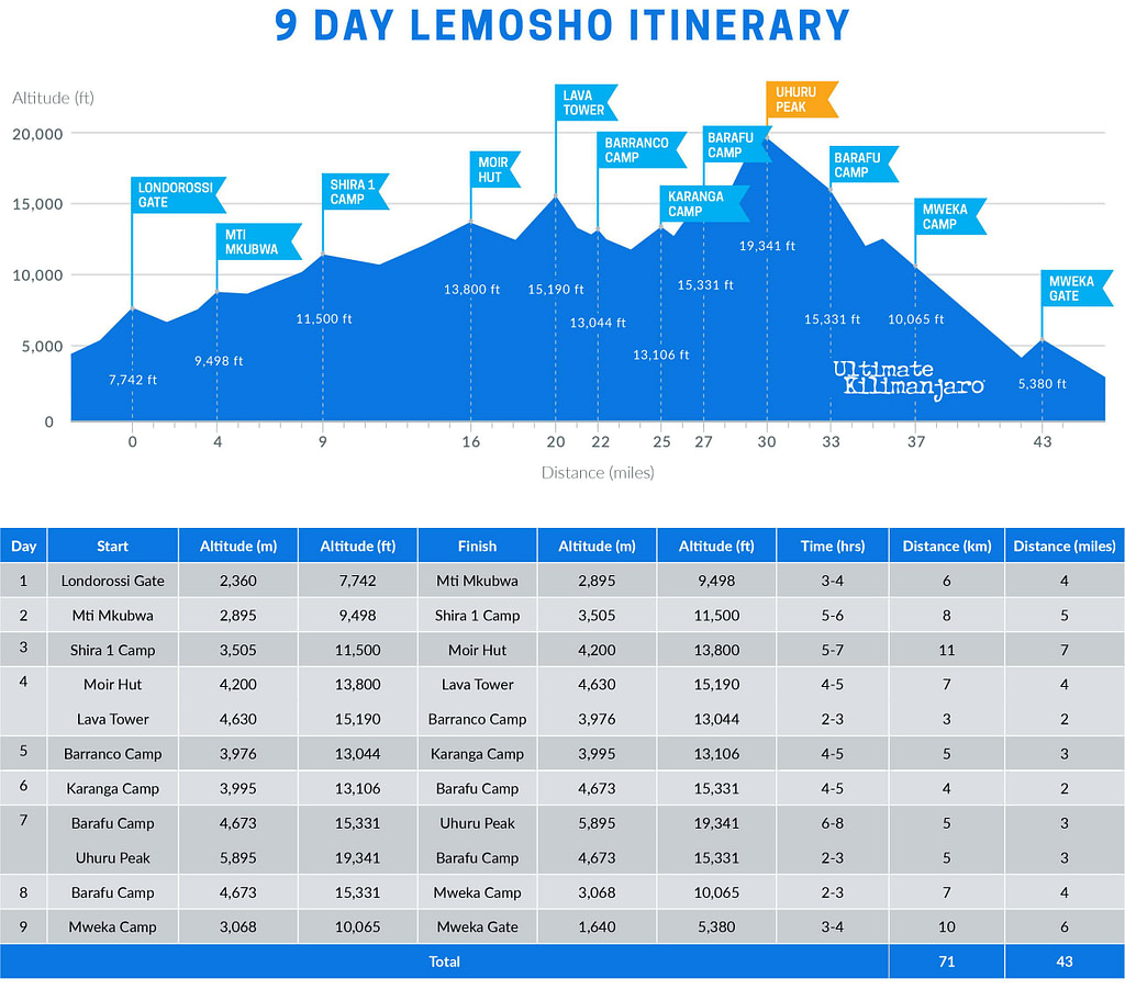
DAY 1 – Londorossi Gate to Mti Mkubwa
Elevation: 7,742 ft to 9,498 ft
Hiking Time: 3-4 hours
Distance: 6 km | 4 miles
Habitat: Rain Forest
We depart Moshi for Londorossi Gate, which takes about 4 hours, where you will complete entry formalities. Then drive to the Lemosho trailhead. Upon arrival at trailhead, we begin hiking through undisturbed forest which winds to the first camp site.
DAY 2 – Mti Mkubwa to Shira 1 Camp
Elevation: 9,498 ft to 11,500 ft
Hiking Time: 5-6 hours
Distance: 8 km | 5 miles
Habitat: Heath
We continue on the trail leading out of the rain forest and into a savannah of tall grasses, heather and volcanic rock draped with lichen beards. As we ascend through the lush rolling hills and cross several streams, we reach the Shira Ridge before dropping gently down to Shira 1 Camp. Here we catch our first glimpse of Kibo across the plateau.
DAY 3 – Shira 1 Camp to Moir Hut
Elevation: 11,500 ft to 13,800 ft
Hiking Time: 5-7 hours
Distance: 11 km | 7 miles
Habitat: Heath
We explore the Shira Plateau for a full day. It is a gentle walk east on moorland meadows towards Shira 2 Camp. Then we divert from the main trail to Moir Hut, a little used site on the base of Lent Hills. A variety of walks are available on Lent Hills making this an excellent acclimatization opportunity. Shira Plateau is one of the highest plateaus on earth.
DAY 4 – Moir Hut to Lava Tower to Barranco Camp
Moir Hut to Lava Tower
Elevation: 13,800 ft to 15,190 ft
Hiking Time: 4-5 hours
Lava Tower to Barranco Camp
Elevation: 15,190 ft to 13,044 ft
Hiking Time: 2-3 hours
.
Distance: 7 km | 4 miles
Habitat: Alpine Desert
.
Distance: 3 km | 2 miles
Habitat: Alpine Desert
We begin the day climbing up a ridge and then head southeast towards the Lava Tower – a 300 ft tall volcanic rock formation. We descend down to Barranco Camp through the strange but beautiful Senecio Forest to an altitude of 13,000 ft. Although you begin and end the day at the same elevation, the time spent at higher altitude is very beneficial for acclimatization.
DAY 5 – Barranco Camp to Karanga Camp
Elevation: 13,044 ft to 13,106 ft
Hiking Time: 4-5 hours
Distance: 5 km | 3 miles
Habitat: Alpine Desert
We begin the day by descending into a ravine to the base of the Great Barranco Wall. Then we climb the non-technical but steep, nearly 900 ft cliff. From the top of the Barranco Wall we cross a series of hills and valleys until we descend sharply into Karanga Valley. One more steep climb up leads us to Karanga Camp. This is a shorter day meant for acclimatization.
DAY 6 – Karanga Camp to Barafu Camp
Elevation: 13,106 ft to 15,331 ft
Hiking Time: 4-5 hours
Distance: 4 km | 2 miles
Habitat: Alpine Desert
We leave Karanga and hit the junction which connects with the Mweka Trail. We continue up to the rocky section to Barafu Hut. At this point, you have completed the Southern Circuit, which offers views of the summit from many different angles. Here we make camp, rest and enjoy dinner while preparing for the summit day. The two peaks of Mawenzi and Kibo are viewable from this position.
DAY 7 – Barafu Camp to Uhuru Peak to Barafu Camp
Barafu Camp to Uhuru Peak
Elevation: 15,331 ft to 19,341 ft
Hiking Time: 6-8 hours
Uhuru Peak to Barafu Camp
Elevation: 19,341 ft to 15,331ft
Hiking Time: 2-3 hours
In the morning light, we begin our push to the summit. This is the most mentally and physically challenging portion of the trek. We ascend for several hours while taking frequent, but short, breaks. Upon reaching the crater rim, you arrive at Stella Point (18,900 ft), with the summit within striking distance. Finally, we arrive at Uhuru Peak – the highest point on Mount Kilimanjaro and the continent of Africa.
From the summit, we return back to Barafu Camp, where we celebrate our achievement and enjoy a well-earned sleep.
DAY 8 – Barafu Camp to Mweka Camp
Elevation: 15,331 ft to 10,065 ft
Hiking Time: 2-3 hours
Distance: 7 km | 4 miles
Habitat: Rain Forest
We make our descent going straight down to Mweka Camp, which is situated in the upper forest. The trail is very rocky and can be quite hard on the knees; trekking poles are helpful. Later in the evening, we have our last dinner on the mountain.
DAY 9 – Mweka Camp to Mweka Gate
Elevation: 10,065 ft to 5,380 ft
Hiking Time: 3-4 hours
Distance: 10 km | 6 miles
Habitat: Rain Forest
On our last day, we continue the descent to Mweka Gate and collect the summit certificates. At lower elevations, it can be wet and muddy. A vehicle takes us back to the hotel in Moshi, where we receive our summit certificates.
9 DAY LEMOSHO CRATER
The 9-Day Lemosho Crater variation follows the 8-day Lemosho route, but includes an overnight stay at Crater Camp. This campsite, located just below the summit, is within the volcanic crater itself. It is the most extreme and exclusive campsite on Mount Kilimanjaro, allowing for exploration of Furtwangler Glacier and the Ash Pit.
Due to the added risk of sleeping at extreme altitude, this route is available as a private climb by special request.
Read more about Crater Camp.
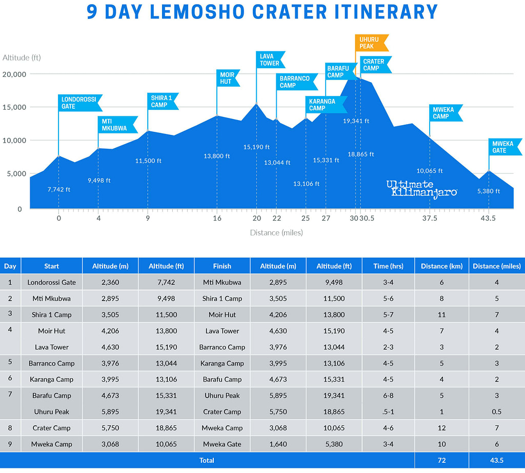
DAY 1 – Londorossi Gate to Mti Mkubwa
Elevation: 7,742 ft to 9,498 ft
Hiking Time: 3-4 hours
Distance: 6 km | 4 miles
Habitat: Rain Forest
We depart Moshi for Londorossi Gate, which takes about 4 hours, where you will complete entry formalities. Then drive to the Lemosho trailhead. Upon arrival at trailhead, we begin hiking through undisturbed forest which winds to the first camp site.
DAY 2 – Mti Mkubwa to Shira 1 Camp
Elevation: 9,498 ft to 11,500 ft
Hiking Time: 5-6 hours
Distance: 8 km | 5 miles
Habitat: Heath
We continue on the trail leading out of the rain forest and into a savannah of tall grasses, heather and volcanic rock draped with lichen beards. As we ascend through the lush rolling hills and cross several streams, we reach the Shira Ridge before dropping gently down to Shira 1 Camp. Here we catch our first glimpse of Kibo across the plateau.
DAY 3 – Shira 1 Camp to Moir Hut
Elevation: 11,500 ft to 13,800 ft
Hiking Time: 5-7 hours
Distance: 11 km | 7 miles
Habitat: Heath
We explore the Shira Plateau for a full day. It is a gentle walk east on moorland meadows towards Shira 2 Camp. Then we divert from the main trail to Moir Hut, a little used site on the base of Lent Hills. A variety of walks are available on Lent Hills making this an excellent acclimatization opportunity. Shira Plateau is one of the highest plateaus on earth.
DAY 4 – Moir Hut to Lava Tower to Barranco Camp
Moir Hut to Lava Tower
Elevation: 12,500 ft to 15,190 ft
Hiking Time: 4-5 hours
Lava Tower to Barranco Camp
Elevation: 15,190 ft to 13,044 ft
Hiking Time: 2-3 hours
We begin the day climbing up a ridge and then head southeast towards the Lava Tower – a 300 ft tall volcanic rock formation. We descend down to Barranco Camp through the strange but beautiful Senecio Forest to an altitude of 13,000 ft. Although you begin and end the day at the same elevation, the time spent at higher altitude is very beneficial for acclimatization.
DAY 5 – Barranco Camp to Karanga Camp
Elevation: 13,044 ft to 13,106 ft
Hiking Time: 4-5 hours
Distance: 5 km | 3 miles
Habitat: Alpine Desert
We begin the day by descending into a ravine to the base of the Great Barranco Wall. Then we climb the non-technical but steep, nearly 900 ft cliff. From the top of the Barranco Wall we cross a series of hills and valleys until we descend sharply into Karanga Valley. One more steep climb up leads us to Karanga Camp. This is a shorter day meant for acclimatization.
DAY 6 – Karanga Camp to Barafu Camp
Elevation: 13,106 ft to 15,331 ft
Hiking Time: 4-5 hours
Distance: 4 km | 2 miles
Habitat: Alpine Desert
We leave Karanga and hit the junction which connects with the Mweka Trail. We continue up to the rocky section to Barafu Hut. At this point, you have completed the Southern Circuit, which offers views of the summit from many different angles. Here we make camp, rest and enjoy an early dinner to prepare for the summit day. The two peaks of Mawenzi and Kibo are viewable from this position.
DAY 7 – Barafu Camp to Uhuru Peak to Crater Camp
Barafu Camp to Uhuru Peak
Elevation: 15,331 ft to 19,341 ft
Hiking Time: 6-8 hours
Uhuru Peak to Crater Camp
Elevation: 19,341 ft to 18,865 ft
Hiking Time: 0.5-1 hours
.
Distance: 5 km | 3 miles
Habitat: Arctic
.
Distance: 1 km | 0.6 miles
Habitat: Arctic
During normal morning hours, we begin our push to the summit. This is the most mentally and physically challenging portion of the trek. We ascend for several hours at a slow but steady pace while taking frequent, but short, breaks. The trail turns into heavy scree as we make the steep climb to the crater rim. At Stella Point (18,900 ft), we see the summit sign in the distance. We continue the around the crater rim until finally we arrive at Uhuru Peak- the highest point on Mount Kilimanjaro and the continent of Africa.
We then descend a short distance to Crater Camp, where the rest of the staff will join us to set up camp. There is an option to hike to Reusch Crater and the ash pit, or simply explore the areas around Furtwangler Glacier. Sleeping at this high altitude can be dangerous. Serious AMS can develop if adequate altitude acclimatization has not been achieved so the guides will monitor you very closely.
DAY 8 – Crater Camp to Mweka Camp
Elevation: 18,865 ft to 10,065 ft
Hiking Time: 4-6 hours
Distance: 12 km | 7 miles
Habitat: Artic
From Crater Camp, we now make our descent continuing straight down to the Mweka Hut camp site, stopping at Barafu for lunch. The trail is very rocky and can be quite hard on the knees; trekking poles are helpful. Mweka Camp is situated in the upper forest and mist or rain can be expected in the late afternoon. Later in the evening, we enjoy our last dinner on the mountain and a well-earned sleep.
DAY 9 – Mweka Camp to Mweka Gate
Elevation: 10,065 ft to 5,380 ft
Hiking Time: 3-4 hours
Distance: 10 km | 6 miles
Habitat: Rain Forest
On our last day, we continue the descent to Mweka Gate and collect the summit certificates. At lower elevations, it can be wet and muddy. A vehicle will meet us at Mweka Village to drive us back to the hotel in Moshi.
7 DAY LEMOSHO (PRIVATE CLIMB ONLY)
The 7-Day Lemosho Route is a shortened variation of the standard itinerary. It skips the Moir Hut acclimatization day by continuing from Shira 1 Camp to Shira 2 Camp on Day 2. This route still offers the scenic beauty of Lemosho, but follows a faster pace and is better suited for experienced trekkers or those with prior high-altitude experience.
DAY 1 – Londorossi Gate to Mti Mkubwa
Elevation: 7,742 ft to 9,498 ft
Hiking Time: 3-4 hours
Distance: 6 km | 4 miles
Habitat: Rain Forest
We depart Moshi for Londorossi Gate, which takes about 4 hours, where you will complete entry formalities. Then drive to the Lemosho trailhead. Upon arrival at trailhead, we begin hiking through undisturbed forest which winds to the first camp site.
DAY 2 – Mti Mkubwa to Shira 1 Camp to Shira 2 Camp
Mti Mkubwa to Shira 1 Camp
Elevation: 9,498 ft to 11,500 ft
Hiking Time: 5-6 hours
Shira 1 Camp to Shira 2 Camp
Elevation: 11,500 ft to 12,500 ft
Hiking Time: 3-4 hours
.
Distance: 8 km | 5 miles
Habitat: Heath
.
Distance: 7 km | 4 miles
Habitat: Heath
We continue on the trail leading out of the rain forest and into a savannah of tall grasses, heather and volcanic rock draped with lichen beards. After reaching Shira Ridge and Shira 1 Camp, we continue east across the Shira Plateau toward Shira 2 Camp, enjoying open moorland views and our first clear looks at Kibo across the plateau.
DAY 3 – Shira 2 Camp to Lava Tower to Barranco Camp
Shira 2 Camp to Lava Tower
Elevation: 12,500 ft to 15,190 ft
Hiking Time: 4-5 hours
Lava Tower to Barranco Camp
Elevation: 15,190 ft to 13,044 ft
Hiking Time: 2-3 hours
.
Distance: 10 km | 6 miles
Habitat: Alpine Desert
.
Distance: 3 km | 2 miles
Habitat: Alpine Desert
We begin the day climbing up a ridge and then head southeast towards the Lava Tower – a 300 ft tall volcanic rock formation. We descend down to Barranco Camp through the strange but beautiful Senecio Forest to an altitude of 13,000 ft. Although you begin and end the day at a similar elevation, the time spent at higher altitude is very beneficial for acclimatization.
DAY 4 – Barranco Camp to Karanga Camp
Elevation: 13,044 ft to 13,106 ft
Hiking Time: 4-5 hours
Distance: 5 km | 3 miles
Habitat: Alpine Desert
We begin the day by descending into a ravine to the base of the Great Barranco Wall. Then we climb the non-technical but steep, nearly 900 ft cliff. From the top of the Barranco Wall we cross a series of hills and valleys until we descend sharply into Karanga Valley. One more steep climb up leads us to Karanga Camp. This is a shorter day meant for acclimatization.
DAY 5 – Karanga Camp to Barafu Camp
Elevation: 13,106 ft to 15,331 ft
Hiking Time: 4-5 hours
Distance: 4 km | 2 miles
Habitat: Alpine Desert
We leave Karanga and hit the junction which connects with the Mweka Trail. We continue up to the rocky section to Barafu Hut. At this point, you have completed the Southern Circuit, which offers views of the summit from many different angles. Here we make camp, rest and enjoy an early dinner to prepare for the summit day. The two peaks of Mawenzi and Kibo are viewable from this position.
DAY 6 – Barafu Camp to Uhuru Peak to Mweka Camp
Barafu Camp to Uhuru Peak
Elevation: 15,331 ft to 19,341 ft
Hiking Time: 6-8 hours
Uhuru Peak to Mweka Camp
Elevation: 19,341 ft to 10,065 ft
Hiking Time: 4-6 hours
Very early in the morning (around midnight), we begin our push to the summit. This is the most mentally and physically challenging portion of the trek. The wind and cold at this elevation and time of day can be extreme. We ascend in the darkness for several hours while taking frequent, but short, breaks. Near Stella Point (18,900 ft), you will be rewarded with the most magnificent sunrise you are ever likely to see coming over Mawenzi Peak. Finally, we arrive at Uhuru Peak– the highest point on Mount Kilimanjaro and the continent of Africa.
From the summit, we now make our descent continuing straight down to the Mweka Hut camp site, stopping at Barafu for lunch. The trail is very rocky and can be quite hard on the knees; trekking poles are helpful. Mweka Camp is situated in the upper forest and mist or rain can be expected in the late afternoon. Later in the evening, we enjoy our last dinner on the mountain and a well-earned sleep.
DAY 7 – Mweka Camp to Mweka Gate
Elevation: 10,065 ft to 5,380 ft
Hiking Time: 3-4 hours
Distance: 10 km | 6 miles
Habitat: Rain Forest
On our last day, we continue the descent to Mweka Gate and collect the summit certificates. At lower elevations, it can be wet and muddy. A vehicle will meet us at Mweka Village to drive us back to the hotel in Moshi.
ROUTE FAQs
How Long is the Lemosho Route?
The distance of the Lemosho route is approximately 70 km or 42 miles. The total elevation gain ranges from approximately 16,000 to 17,000 feet.
How Many Days Does it Take to Climb Kilimanjaro on the Lemosho Route?
The Lemosho route has several variations and thus, the trail can be completed in as little as 6 days and as many as 9 days. The standard itinerary is the preferred variation which requires 8 days.
How Hard is it to Climb Kilimanjaro on the Lemosho Route?
The Lemosho route is considered a moderately difficult route due to its distance and elevation gain. The up and down nature of the trail is strenuous. However, when you factor in the favorable acclimatization schedule, it is actually very manageable.
What is the Success Rate of Climbing Kilimanjaro on the Lemosho Route?
The success rate depends on the number of days you spend on the mountain. For all operators combined, it is estimated that 6 day Lemosho climbs have a success rate of about 60%, 7 day Lemosho climbs have a success rate of around 80%, and 8 day Lemosho climbs have a success rate of about 90%. Our success rate for 8 and 9 day Lemosho has historically ranged between 90-95%.
How Much Does it Cost to Climb Kilimanjaro on the Lemosho Route?
The cost of the Lemosho route varies based on the number of days. See our prices here.
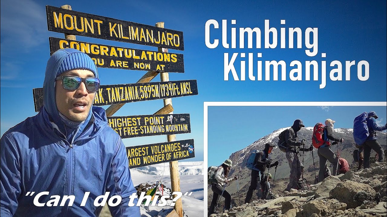
See our epic feature film where an Ultimate Kilimanjaro® group tackles the 8 day Lemosho route.