Northern Crater Route
Lemosho Crater Route

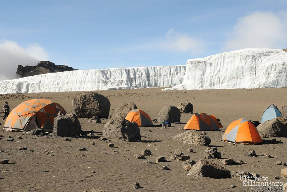
Crater Camp is a unique place.

At 18,865 feet above sea level, it is the highest campsite on Mount Kilimanjaro. It is located just 475 feet below the summit.

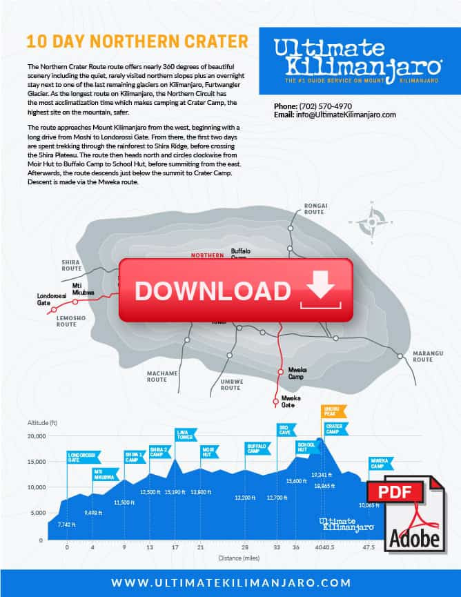
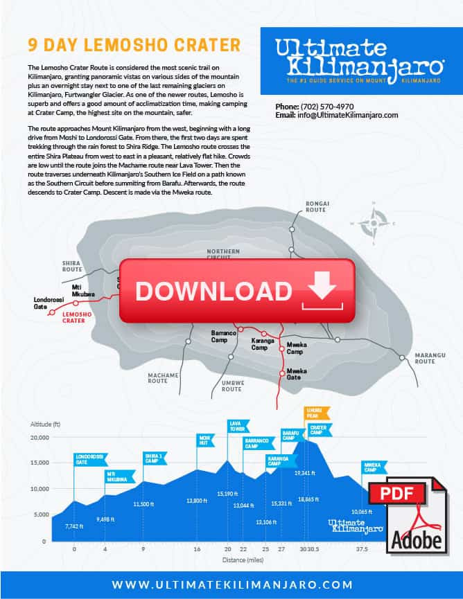
We offer the opportunity to stay at Crater Camp on the Lemosho and Northern Circuit routes. This option will add one day to the standard itineraries making them the 9 Lemosho Crater Route and 10 day Northern Crater Route.

We leave for the summit during daylight hours and stay at Crater Camp after the summit for better acclimatization.

On all other Kilimanjaro routes, only the guides and clients summit while the rest of the mountain crew remains at high camp (i.e. Barafu). Using Crater Camp requires significantly more effort on our part as the entire mountain crew, along with all of the expedition equipment, has to ascend 4,000 feet higher than they normally would. Therefore, there is considerable added cost to do a Crater Camp route.

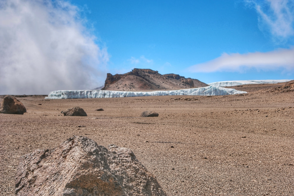
From Crater Camp, one can take an optional one hour hike to Reusch Crater, or simply explore the areas around Furtwangler Glacier. Reusch Crater is a magnificent sight. It is almost perfectly circular and the ash pit measures 400 feet (120 m) deep and 1,300 feet (400 m) wide. This is rarely seen by tourists. The video below puts the size of the ash pit and crater into perspective.

YouTube player

We understand the attraction of staying at Crater Camp. However, the drawback of sleeping at this high altitude is that it is pretty dangerous. Serious AMS can develop if adequate altitude acclimatization has not been achieved.

(See Should We Sleep at Crater Camp?).

Due to safety concerns for clients and staff, the 9 Lemosho Crater Route and 10 day Northern Crater Route are done only by special request and are subject to approval by Ultimate Kilimanjaro®.

How Long are the Crater Camp Routes?

The distance of the 9 day Lemosho Crater is approximately 72 km or 43.5 miles.

The distance of the 10 day Northern Crater is approximately 89 km or 53.5 miles.

How Many Days Does it Take to Climb Kilimanjaro using Crater Camp Routes?

The Crater Camp routes are typically done in 9 or 10 days.

How Hard is it to Climb Kilimanjaro on Crater Camp Routes?

Sleeping at the high elevation of Crater Camp adds acclimatization challenges relative to summiting and descending on the same day. Therefore, these routes are considered to be difficult due to the increased risk of altitude sickness. We mitigate this risk by only allowing stays at Crater Camp on our longest routes.

What is the Success Rate of Climbing Kilimanjaro using the Crater Camp Routes?

The success rate of the Crater Camp routes are identical to their non-Crater Camp variations because the night at Crater Camp occurs after the summit. The 8 day Lemosho Crater has a success rate of about 90%. The success rate of the 9 day Northern Crater route is about 95%.

How Much Does it Cost to Climb Kilimanjaro on the Crater Camp Routes?

The cost to climb the crater camp routes will vary between operators. Our current pricing for a private climb on the 9 day Lemosho Crater route starts at $4,099 per person. Our current pricing for a private climb on the 10 day Northern Crater route starts at $4,479 per person.


9 DAY LEMOSHO CRATER ITINERARY

DAY 1 – Londorossi Gate to Mti Mkubwa

Elevation: 7,742 ft to 9,498 ft

Hiking Time:  3-4 hours

Distance: 6 km | 4 miles

Habitat: Rain Forest

We depart Moshi for Londorossi Gate, which takes about 4 hours, where you will complete entry formalities. Then drive to the Lemosho trailhead. Upon arrival at trailhead, we begin hiking through undisturbed forest which winds to the first camp site.

DAY 2 – Mti Mkubwa to Shira 1 Camp

Elevation: 9,498 ft to 11,500 ft

Hiking Time: 5-6 hours

Distance: 8 km | 5 miles

Habitat: Heath

We continue on the trail leading out of the rain forest and into a savannah of tall grasses, heather and volcanic rock draped with lichen beards. As we ascend through the lush rolling hills and cross several streams, we reach the Shira Ridge before dropping gently down to Shira 1 Camp. Here we catch our first glimpse of Kibo across the plateau.

DAY 3 – Shira 1 Camp to Moir Hut

Elevation: 11,500 ft to 13,800 ft

Hiking Time: 5-7 hours

Distance: 11 km | 7 miles

Habitat: Heath

We explore the Shira Plateau for a full day. It is a gentle walk east on moorland meadows towards Shira 2 Camp. Then we divert from the main trail to Moir Hut, a little used site on the base of Lent Hills. A variety of walks are available on Lent Hills making this an excellent acclimatization opportunity. Shira Plateau is one of the highest plateaus on earth.

DAY 4 –  Moir Hut to Lava Tower to Barranco Camp

Moir Hut to Lava Tower

Elevation: 12,500 ft to 15,190 ft

Hiking Time: 4-5 hours

Lava Tower to Barranco Camp

Elevation: 15,190 ft to 13,044 ft

Hiking Time: 2-3 hours

.

Distance: 7 km | 4 miles

Habitat: Alpine Desert

.

Distance: 3 km | 2 miles

Habitat: Alpine Desert

We begin the day climbing up a ridge and then head southeast towards the Lava Tower – a 300 ft tall volcanic rock formation. We descend down to Barranco Camp through the strange but beautiful Senecio Forest to an altitude of 13,000 ft. Although you begin and end the day at the same elevation, the time spent at higher altitude is very beneficial for acclimatization.

DAY 5 – Barranco Camp to Karanga Camp

Elevation: 13,044 ft to 13,106 ft

Hiking Time: 4-5 hours

Distance: 5 km | 3 miles

Habitat: Alpine Desert

We begin the day by descending into a ravine to the base of the Great Barranco Wall. Then we climb the non-technical but steep, nearly 900 ft cliff. From the top of the Barranco Wall we cross a series of hills and valleys until we descend sharply into Karanga Valley. One more steep climb up leads us to Karanga Camp. This is a shorter day meant for acclimatization.

DAY 6 – Karanga Camp to Barafu Camp

Elevation: 13,106 ft to 15,331 ft

Hiking Time: 4-5 hours

Distance: 4 km | 2 miles

Habitat: Alpine Desert

We leave Karanga and hit the junction which connects with the Mweka Trail. We continue up to the rocky section to Barafu Hut. At this point, you have completed the Southern Circuit, which offers views of the summit from many different angles. Here we make camp, rest and enjoy an early dinner to prepare for the summit day. The two peaks of Mawenzi and Kibo are viewable from this position.

DAY 7 –  Barafu Camp to Uhuru Peak to Crater Camp

Barafu Camp to Uhuru Peak

Elevation: 15,331 ft to 19,341 ft

Hiking Time: 7-8 hours

Uhuru Peak to Crater Camp

Elevation: 19,341 ft to 18,865 ft

Hiking Time: 0.5-1 hours

.

Distance: 5 km | 3 miles

Habitat: Arctic

.

Distance: 1 km | 0.6 miles

Habitat: Arctic

During normal morning hours, we begin our push to the summit. This is the most mentally and physically challenging portion of the trek. We ascend for several hours at a slow but steady pace while taking frequent, but short, breaks. The trail turns into heavy scree as we make the steep climb to the crater rim. At Stella Point (18,900 ft), we see the summit sign in the distance. We continue the around the crater rim until finally we arrive at Uhuru Peak- the highest point on Mount Kilimanjaro and the continent of Africa.

We then descend a short distance to Crater Camp, where the rest of the staff will join us to set up camp. There is an option to hike to Reutsch Crater and the ash pit, or simply explore the areas around Furtwangler Glacier. Sleeping at this high altitude can be dangerous. Serious AMS can develop if adequate altitude acclimatization has not been achieved so the guides will monitor you very closely.

DAY 8 – Crater Camp to Mweka Camp

Elevation: 18,865 ft to 10,065 ft

Hiking Time: 4-6 hours

Distance: 12 km | 7 miles

Habitat: Artic

From Crater Camp, we now make our descent continuing straight down to the Mweka Hut camp site, stopping at Barafu for lunch. The trail is very rocky and can be quite hard on the knees; trekking poles are helpful. Mweka Camp is situated in the upper forest and mist or rain can be expected in the late afternoon. Later in the evening, we enjoy our last dinner on the mountain and a well-earned sleep.

DAY 9 – Mweka Camp to Mweka Gate

Elevation: 10,065 ft to 5,380 ft

Hiking Time: 3-4 hours

Distance: 10 km | 6 miles

Habitat: Rain Forest

On our last day, we continue the descent to Mweka Gate and collect the summit certificates. At lower elevations, it can be wet and muddy. From the gate, we continue another hour to Mweka Village. A vehicle will meet us at Mweka Village to drive us back to the hotel in Moshi.


10 DAY NORTHERN CRATER ITINERARY

DAY 1 – Londorossi Gate to Mti Mkubwa

Elevation: 7,742 ft to 9,498 ft

Hiking Time:  3-4 hours

Distance: 6 km | 4 miles

Habitat: Rain Forest

We depart Moshi for Londorossi Gate, which takes about 4 hours, where you will complete entry formalities. Then drive to the Lemosho trailhead. Upon arrival at trailhead, we begin hiking through undisturbed forest which winds to the first camp site.

DAY 2 – Mti Mkubwa to Shira 1 Camp

Elevation: 9,498 ft to 11,500 ft

Hiking Time: 5-6 hours

Distance: 8 km | 5 miles

Habitat: Heath

We continue on the trail leading out of the rain forest and into a savannah of tall grasses, heather and volcanic rock draped with lichen beards. As we ascend through the lush rolling hills and cross several streams, we reach the Shira Ridge before dropping gently down to Shira 1 Camp. Here we catch our first glimpse of Kibo across the plateau.

DAY 3 – Shira 1 Camp to Shira 2 Camp

Elevation: 11,500 ft to 12,500 ft

Hiking Time: 3-4 hours

Distance: 7 km | 4 miles

Habitat: Heath

We explore the Shira Plateau. It is a gentle walk east on moorland meadows towards Shira 2 Camp. The heath zone displays abundant wildflowers and unique Senecio trees.

DAY 4 –  Shira 2 Camp to Lava Tower to Moir Hut

Shira 2 Camp to Lava Tower

Elevation: 12,500 ft to 15,190 ft

Hiking Time: 3-4 hours

Lava Tower to Moir Hut

Elevation: 15,190 ft to 13,580 ft

Hiking Time: 2-3 hours

.

Distance: 7 km | 4 miles

Habitat: Alpine Desert

.

Distance: 6 km | 4 miles

Habitat: Alpine Desert

We continue to the east up a ridge and then head southeast towards the Lava Tower – a 300 ft tall volcanic rock formation. Then we divert from the main trail to Moir Hut, a little used site on the base of Lent Hills. A variety of walks are available on Lent Hills making this an excellent acclimatization opportunity. Shira Plateau is one of the highest plateaus on earth.

DAY 5 – Moir Hut to Buffalo Camp

Elevation: 13,580 ft to 13,200 ft

Hiking Time: 5-7 hours

Distance: 12 km | 7 miles

Habitat: Alpine Desert

We trek out of Moir Valley with a moderately steep climb, then hike to the summit of Lent Hills before returning to the main trail. The path crosses a rock field and gently undulates before reaching Buffalo Camp. This section of the trail offers great views across the plains that lie north of Kilimanjaro and stretch out to the Kenyan/Tanzanian border.

DAY 6 – Buffalo Camp to Third Cave

Elevation: 13,200 ft to 12,700 ft

Hiking Time: 5-7 hours

Distance: 8 km | 5 miles

Habitat: Heath

As we head up Buffalo Ridge, the terrain becomes increasingly sparse. This route is rarely travelled and we will enjoy its mountain wilderness feel. We trek through remote valleys on to the northern slopes of Kilimanjaro until we arrive at Third Cave.

DAY 7 – Third Cave to School Hut

Elevation: 12,700 ft to 15,600 ft

Hiking Time: 4-5 hours

Distance: 5 km | 3 miles

Habitat: Alpine Desert

We climb steadily up and over the “Saddle,” which sits between Kibo and Mawenzi. We continue on to our camp, School Hut. Once here we rest, enjoy dinner and prepare for the summit day.

DAY 8 –  School Hut to Uhuru Peak to Crater Camp

School Hut to Uhuru Peak

Elevation: 15,600 ft to 19,341 ft

Hiking Time: 6-8 hours

Uhuru Peak to Crater Camp

Elevation: 19,341 ft to 18,865 ft

Hiking Time: 0.5-1 hours

.

Distance: 6 km | 4 miles

Habitat: Arctic

.

Distance: 1 km | 0.6 miles

Habitat: Arctic

During normal morning hours, we begin our push to the summit. This is the most mentally and physically challenging portion of the trek. We ascend for several hours at a slow but steady pace while taking frequent, but short, breaks. The trail turns into heavy scree as we make the steep climb to the crater rim. At Gilman’s Point (18,600 ft), we see the summit sign in the distance. We continue the around the crater rim until finally we arrive at Uhuru Peak- the highest point on Mount Kilimanjaro and the continent of Africa.

We then descend a short distance to Crater Camp, where the rest of the staff will join us to set up camp. There is an option to hike to Reutsch Crater and the ash pit, or simply explore the areas around Furtwangler Glacier. Sleeping at this high altitude can be dangerous. Serious AMS can develop if adequate altitude acclimatization has not been achieved so the guides will monitor you very closely.

DAY 9 – Crater Camp to Mweka Camp

Elevation: 18,865 ft to 10,065 ft

Hiking Time: 4-6 hours

Distance: 12 km | 7 miles

Habitat: Artic

From Crater Camp, we now make our descent continuing straight down to the Mweka Hut camp site, stopping at Barafu for lunch. The trail is very rocky and can be quite hard on the knees; trekking poles are helpful. Mweka Camp is situated in the upper forest and mist or rain can be expected in the late afternoon. Later in the evening, we enjoy our last dinner on the mountain and a well-earned sleep.

DAY 10 – Mweka Camp to Mweka Gate

Elevation: 10,065 ft to 5,380 ft

Hiking Time: 3-4 hours

Distance: 10 km | 6 miles

Habitat: Rain Forest

On our last day, we continue the descent to Mweka Gate and collect the summit certificates. At lower elevations, it can be wet and muddy. From the gate, we continue another hour to Mweka Village. A vehicle will meet us at Mweka Village to drive us back to the hotel in Moshi.