

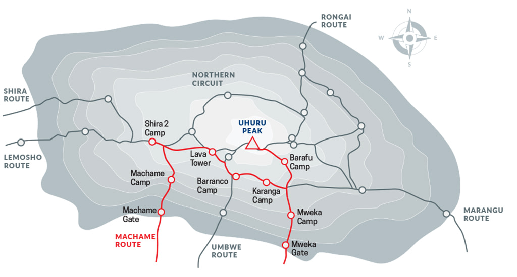
The Machame route, also known as the “Whiskey” route, is the most popular route on Kilimanjaro.
Machame’s draw is in its scenic beauty. However, the trail is considered difficult, steep and challenging, particularly due to its shorter itinerary. Therefore this route is better suited for more adventurous folks or those with some high altitude, hiking or backpacking experience.
The route approaches Mount Kilimanjaro from the south, beginning with a short drive from Moshi to Machame Gate. The path leads hikers through the rain forest to Shira Plateau. Here, many of Kilimanjaro’s routes converge. Then the route turns east and traverses underneath Kilimanjaro’s Southern Ice Field on a path known as the Southern Circuit before summiting from Barafu. Descent is made via the Mweka route.
Ultimate Kilimanjaro® offers Machame as a private climb, with itinerary variations ranging from 6 to 8 days.
7 DAY MACHAME (STANDARD ROUTE)
The 7-Day Machame Route is the standard itinerary and our recommended version of this route. The overnight at Karanga camp on day four allows more time for acclimatization and better recovery before the summit push.
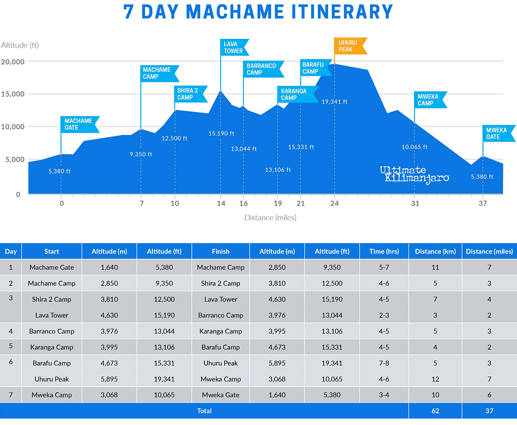
DAY 1 – Machame Gate to Machame Camp
Elevation: 5,380 ft to 9,350 ft
Hiking Time: 5-7 hours
Distance: 11 km | 7 miles
Habitat: Rain Forest
The drive from Moshi to the Machame Gate takes about 50 minutes. The journey passes through the village of Machame which is located on the lower slopes of the mountain. As we leave the park gate, we walk through the dense rain forest on a winding trail up a ridge until we reach the Machame Camp.
DAY 2 – Machame Camp to Shira 2 Camp
Elevation: 9,350 ft to 12,500 ft
Hiking Time: 4-6 hours
Distance: 5 km | 3 miles
Habitat: Heath
We leave the glades of the rain forest and continue on an ascending path up to a steep, rocky ridge. On the Shira Plateau, we pass through heather and open moorlands, then cross a large river gorge to Shira 2 Camp.
DAY 3 – Shira 2 Camp to Lava Tower to Barranco Camp
Shira 2 Camp to Lava Tower
Elevation: 12,500 ft to 15,190 ft
Hiking Time: 4-5 hours
Lava Tower to Barranco Camp
Elevation: 15,190 ft to 13,044 ft
Hiking Time: 2-3 hours
.
Distance: 7 km | 4 miles
Habitat: Alpine Desert
.
Distance: 3 km | 2 miles
Habitat: Alpine Desert
We continue to the east up a ridge and then head southeast towards the Lava Tower – a 300 ft tall volcanic rock formation. We descend down to Barranco Camp through the strange but beautiful Senecio Forest to an altitude of 13,000 ft. Although you begin and end the day at the same elevation, the time spent at higher altitude is very beneficial for acclimatization.
DAY 4 – Barranco Camp to Karanga Camp
Elevation: 13,044 ft to 13,106 ft
Hiking Time: 4-5 hours
Distance: 5 km | 3 miles
Habitat: Alpine Desert
We begin the day by descending into a ravine to the base of the Great Barranco Wall. Then we climb the non-technical but steep, nearly 900 ft cliff. From the top of the Barranco Wall we cross a series of hills and valleys until we descend sharply into Karanga Valley. One more steep climb up leads us to Karanga Camp. This is a shorter day meant for acclimatization.
DAY 5 – Karanga Camp to Barafu Camp
Elevation: 13,106 ft to 15,331 ft
Hiking Time: 4-5 hours
Distance: 4 km | 2 miles
Habitat: Alpine Desert
We leave Karanga and hit the junction which connects with the Mweka Trail. We continue up to the rocky section to Barafu Hut. At this point, you have completed the Southern Circuit, which offers views of the summit from many different angles. Here we make camp, rest and enjoy an early dinner to prepare for the summit day. The two peaks of Mawenzi and Kibo are viewable from this position.
DAY 6 – Barafu Camp to Uhuru Peak to Mweka Camp
Barafu Camp to Uhuru Peak
Elevation: 15,331 ft to 19,341 ft
Hiking Time: 6-8 hours
Uhuru Peak to Mweka Camp
Elevation: 19,341 ft to 10,065 ft
Hiking Time: 4-6 hours
.
Distance: 5 km | 3 miles
Habitat: Arctic
.
Distance: 12 km | 7 miles
Habitat: Rain Forest
Very early in the morning (around midnight), we begin our push to the summit. This is the most mentally and physically challenging portion of the trek. The wind and cold at this elevation and time of day can be extreme. We ascend in the darkness for several hours while taking frequent, but short, breaks. Near Stella Point (18,900 ft), you will be rewarded with the most magnificent sunrise you are ever likely to see coming over Mawenzi Peak. Finally, we arrive at Uhuru Peak– the highest point on Mount Kilimanjaro and the continent of Africa.
From the summit, we now make our descent continuing straight down to the Mweka Hut camp site, stopping at Barafu for lunch. The trail is very rocky and can be quite hard on the knees; trekking poles are helpful. Mweka Camp is situated in the upper forest and mist or rain can be expected in the late afternoon. Later in the evening, we enjoy our last dinner on the mountain and a well-earned sleep.
DAY 7 – Mweka Camp to Mweka Gate
Elevation: 10,065 ft to 5,380 ft
Hiking Time: 3-4 hours
Distance: 10 km | 6 miles
Habitat: Rain Forest
On our last day, we continue the descent to Mweka Gate and collect the summit certificates. At lower elevations, it can be wet and muddy. A vehicle will meet us at Mweka Village to drive us back to the hotel in Moshi.
8 DAY MACHAME (DAYTIME SUMMIT)
The 8-Day Machame (Daytime Summit) variation follows the 7-day Machame route, but replaces the traditional midnight summit with a daytime ascent. It avoids the extreme cold and windy nighttime conditions, while also shortening the duration of summit day. Thus, summit day is more comfortable and less physically demanding.
After summiting, climbers descend to Barafu Camp instead of Mweka Camp. This easier-paced descent adds one day to the itinerary.
Read more about Daytime Summit Routes.
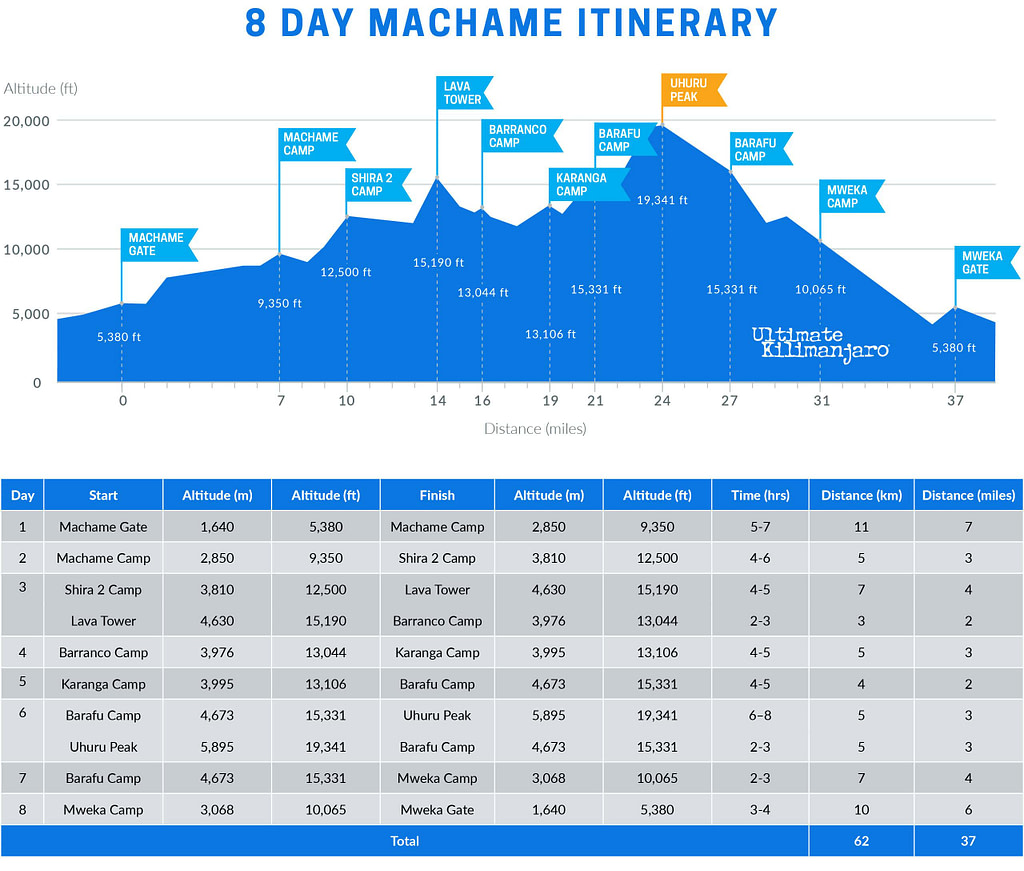
DAY 1 – Machame Gate to Machame Camp
Elevation: 5,380 ft to 9,350 ft
Hiking Time: 5-7 hours
Distance: 11 km | 7 miles
Habitat: Rain Forest
The drive from Moshi to the Machame Gate takes about 50 minutes. The journey passes through the village of Machame which is located on the lower slopes of the mountain. As we leave the park gate, we walk through the dense rain forest on a winding trail up a ridge until we reach the Machame Camp.
DAY 2 – Machame Camp to Shira 2 Camp
Elevation: 9,350 ft to 12,500 ft
Hiking Time: 4-6 hours
Distance: 5 km | 3 miles
Habitat: Heath
We leave the glades of the rain forest and continue on an ascending path up to a steep, rocky ridge. On the Shira Plateau, we pass through heather and open moorlands, then cross a large river gorge to Shira 2 Camp.
DAY 3 – Shira 2 Camp to Lava Tower to Barranco Camp
Shira 2 Camp to Lava Tower
Elevation: 12,500 ft to 15,190 ft
Hiking Time: 4-5 hours
Lava Tower to Barranco Camp
Elevation: 15,190 ft to 13,044 ft
Hiking Time: 2-3 hours
.
Distance: 7 km | 4 miles
Habitat: Alpine Desert
.
Distance: 3 km | 2 miles
Habitat: Alpine Desert
We continue to the east up a ridge and then head southeast towards the Lava Tower – a 300 ft tall volcanic rock formation. We descend down to Barranco Camp through the strange but beautiful Senecio Forest to an altitude of 13,000 ft. Although you begin and end the day at the same elevation, the time spent at higher altitude is very beneficial for acclimatization.
DAY 4 – Barranco Camp to Karanga Camp
Elevation: 13,044 ft to 13,106 ft
Hiking Time: 4-5 hours
Distance: 5 km | 3 miles
Habitat: Alpine Desert
We begin the day by descending into a ravine to the base of the Great Barranco Wall. Then we climb the non-technical but steep, nearly 900 ft cliff. From the top of the Barranco Wall we cross a series of hills and valleys until we descend sharply into Karanga Valley. One more steep climb up leads us to Karanga Camp. This is a shorter day meant for acclimatization.
DAY 5 – Karanga Camp to Barafu Camp
Elevation: 13,106 ft to 15,331 ft
Hiking Time: 4-5 hours
Distance: 4 km | 2 miles
Habitat: Alpine Desert
We leave Karanga and hit the junction which connects with the Mweka Trail. We continue up to the rocky section to Barafu Hut. At this point, you have completed the Southern Circuit, which offers views of the summit from many different angles. Here we make camp, rest and enjoy dinner while preparing for the summit day. The two peaks of Mawenzi and Kibo are viewable from this position.
DAY 6 – Barafu Camp to Uhuru Peak to Barafu Camp
Barafu Camp to Uhuru Peak
Elevation: 15,331 ft to 19,341 ft
Hiking Time: 6-8 hours
Uhuru Peak to Barafu Camp
Elevation: 19,341 ft to 15,331 ft
Hiking Time: 2-3 hours
.
Distance: 5 km | 3 miles
Habitat: Arctic
.
Distance: 5 km | 3 miles
Habitat: Alpine Desert
In the morning light, we begin our push to the summit. This is the most mentally and physically challenging portion of the trek. We ascend for several hours while taking frequent, but short, breaks. Upon reaching the crater rim, you arrive at Stella Point (18,900 ft), with the summit within striking distance. Finally, we arrive at Uhuru Peak – the highest point on Mount Kilimanjaro and the continent of Africa.
From the summit, we return back to Barafu Camp, where we celebrate our achievement and enjoy a well-earned sleep.
DAY 7 – Barafu Camp to Mweka Camp
Elevation: 15,331 ft to 10,065 ft
Hiking Time: 2-3 hours
Distance: 7 km | 4 miles
Habitat: Rain Forest
We make our descent going straight down to Mweka Camp, which is situated in the upper forest. The trail is very rocky and can be quite hard on the knees; trekking poles are helpful. Later in the evening, we have our last dinner on the mountain.
DAY 8 – Mweka Camp to Mweka Gate
Elevation: 10,065 ft to 5,380 ft
Hiking Time: 3-4 hours
Distance: 10 km | 6 miles
Habitat: Rain Forest
On our last day, we continue the descent to Mweka Gate and collect the summit certificates. At lower elevations, it can be wet and muddy. A vehicle takes us back to the hotel in Moshi, where we receive our summit certificates.
6 DAY MACHAME
The 6-Day Machame Route is a shortened variation of the standard itinerary. It removes the overnight at Karanga Camp by combining the trek from Barranco to Barafu into a single day.
DAY 1 – Machame Gate to Machame Camp
Elevation: 5,380 ft to 9,350 ft
Hiking Time: 5-7 hours
Distance: 11 km | 7 miles
Habitat: Rain Forest
The drive from Moshi to the Machame Gate takes about 50 minutes. The journey passes through the village of Machame which is located on the lower slopes of the mountain. As we leave the park gate, we walk through the dense rain forest on a winding trail up a ridge until we reach the Machame Camp.
DAY 2 – Machame Camp to Shira 2 Camp
Elevation: 9,350 ft to 12,500 ft
Hiking Time: 4-6 hours
Distance: 5 km | 3 miles
Habitat: Heath
We leave the glades of the rain forest and continue on an ascending path up to a steep, rocky ridge. On the Shira Plateau, we pass through heather and open moorlands, then cross a large river gorge to Shira 2 Camp.
DAY 3 – Shira 2 Camp to Lava Tower to Barranco Camp
Shira 2 Camp to Lava Tower
Elevation: 12,500 ft to 15,190 ft
Hiking Time: 4-5 hours
Lava Tower to Barranco Camp
Elevation: 15,190 ft to 13,044 ft
Hiking Time: 2-3 hours
.
Distance: 7 km | 4 miles
Habitat: Alpine Desert
.
Distance: 3 km | 2 miles
Habitat: Alpine Desert
We continue to the east up a ridge and then head southeast towards the Lava Tower – a 300 ft tall volcanic rock formation. We descend down to Barranco Camp through the strange but beautiful Senecio Forest to an altitude of 13,000 ft. Although you begin and end the day at the same elevation, the time spent at higher altitude is very beneficial for acclimatization.
DAY 4 – Barranco Camp to Karanga Camp to Barafu Camp
Barranco Camp to Karanga Camp
Elevation: 13,044 ft to 13,106 ft
Hiking Time: 4-5 hours
Karanga Camp to Barafu Camp
Elevation: 13,106 ft to 15,331 ft
Hiking Time: 4-5 hours
.
Distance: 5 km | 3 miles
Habitat: Alpine Desert
.
Distance: 4 km | 2 miles
Habitat: Alpine Desert
We begin the day by descending into a ravine to the base of the Great Barranco Wall. Then we climb the non-technical but steep, nearly 900 ft cliff. From the top of the Barranco Wall we cross a series of hills and valleys until we descend sharply into Karanga Valley. One more steep climb up leads us to Karanga Camp. From Karanga, we hit the junction which connects with the Mweka Trail and continue up to the rocky section to Barafu Hut. Here we make camp, rest and enjoy an early dinner to prepare for the summit day.
DAY 5 – Barafu Camp to Uhuru Peak to Mweka Camp
Barafu Camp to Uhuru Peak
Elevation: 15,331 ft to 19,341 ft
Hiking Time: 6-8 hours
Uhuru Peak to Mweka Camp
Elevation: 19,341 ft to 10,065 ft
Hiking Time: 4-6 hours
.
Distance: 5 km | 3 miles
Habitat: Arctic
.
Distance: 12 km | 7 miles
Habitat: Rain Forest
Very early in the morning (around midnight), we begin our push to the summit. This is the most mentally and physically challenging portion of the trek. The wind and cold at this elevation and time of day can be extreme. We ascend in the darkness for several hours while taking frequent, but short, breaks. Near Stella Point (18,900 ft), you will be rewarded with the most magnificent sunrise you are ever likely to see coming over Mawenzi Peak. Finally, we arrive at Uhuru Peak– the highest point on Mount Kilimanjaro and the continent of Africa.
From the summit, we now make our descent continuing straight down to the Mweka Hut camp site, stopping at Barafu for lunch. The trail is very rocky and can be quite hard on the knees; trekking poles are helpful. Mweka Camp is situated in the upper forest and mist or rain can be expected in the late afternoon. Later in the evening, we enjoy our last dinner on the mountain and a well-earned sleep.
DAY 6 – Mweka Camp to Mweka Gate
Elevation: 10,065 ft to 5,380 ft
Hiking Time: 3-4 hours
Distance: 10 km | 6 miles
Habitat: Rain Forest
On our last day, we continue the descent to Mweka Gate and collect the summit certificates. At lower elevations, it can be wet and muddy. A vehicle will meet us at Mweka Village to drive us back to the hotel in Moshi.
ROUTE FAQs
How Long is the Machame Route?
The distance of the Machame route is approximately 62 km or 37 miles. The total elevation gain ranges from approximately 16,000 to 17,000 feet.
How Many Days Does it Take to Climb Kilimanjaro on the Machame Route?
The Machame route has a few variations and can be completed in 6 to 8 days.
How Hard is it to Climb Kilimanjaro on the Machame Route?
The Machame route is considered a challenging route due to its distance and elevation gain. The up and down nature of the trail is strenuous. However, it does have a decent acclimatization schedule, which makes it a moderately difficult route.
What is the Success Rate of Climbing Kilimanjaro on the Machame Route?
The success rate depends on the number of days you spend on the mountain. For all operators combined, it is estimated that 6 day Machame climbs have a success rate of about 50% and 7 day Machame climbs have a success rate of around 70%. Our 6 day Machame route has a success rate of approximately 70-75% and our 7 and 8 day Machame route has a success rate of approximately 85-90%.
How Much Does it Cost to Climb Kilimanjaro on the Machame Route?
The cost of the Machame route will vary depending on the guide service. See our prices here.