


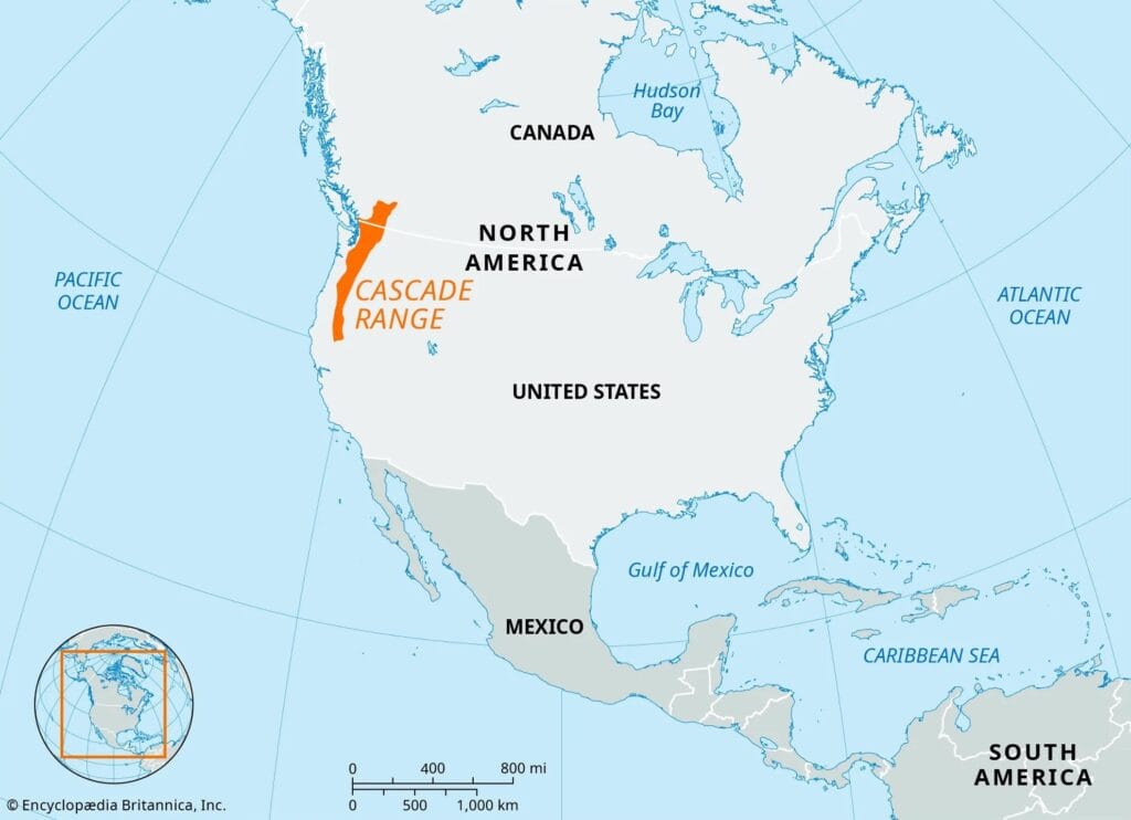
Where are the Cascade Mountains?
The Cascade Range, often referred to as the Cascades, is a major mountain range of western North America. The range stretches from southern British Columbia in Canada through the Pacific Northwest of the USA.
How Long are the Cascade Mountains?
The Cascades Mountains span about 700 miles (approximately 1,126 kilometres) from north to south and is roughly 50 to 80 miles (80 to 129 kilometers) wide.
What States are the Cascade Mountains in?
The Cascades extend from British Columbia in Canada through Washington, Oregon, and Northern California in the United States.
The range is divided into two sections: the High Cascades and the Lower Cascades.
The High Cascades
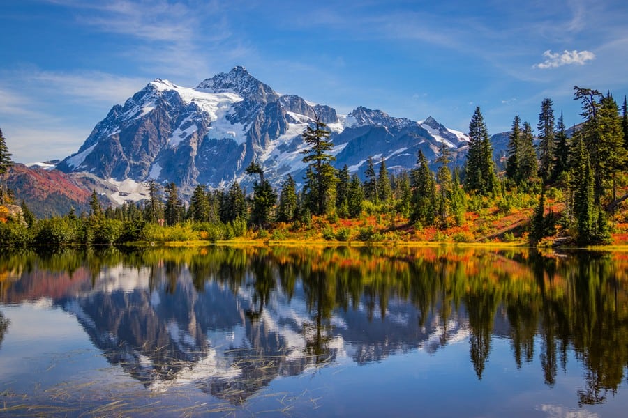
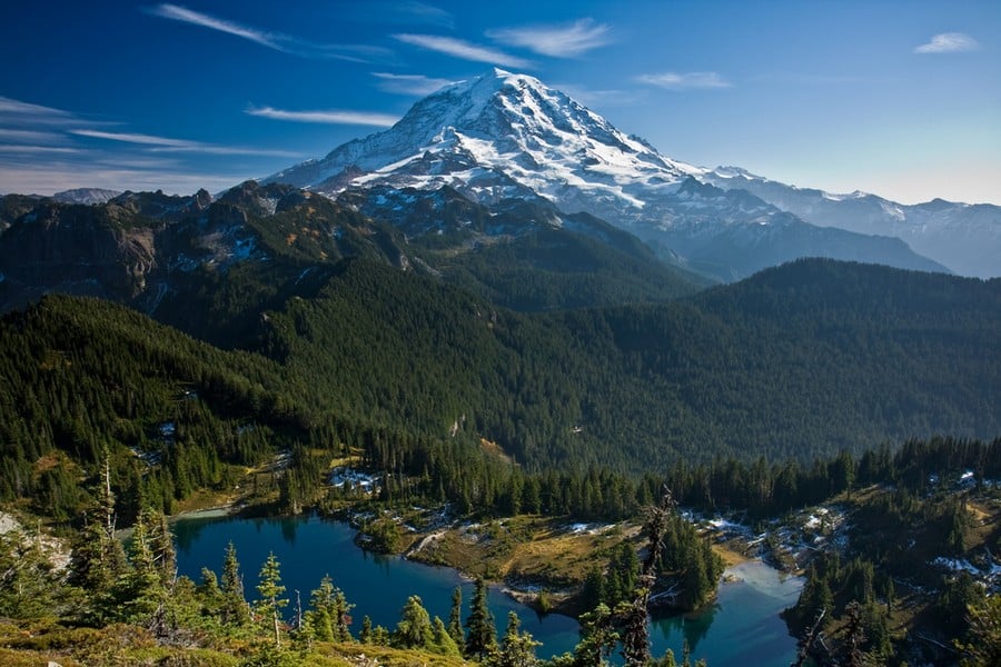
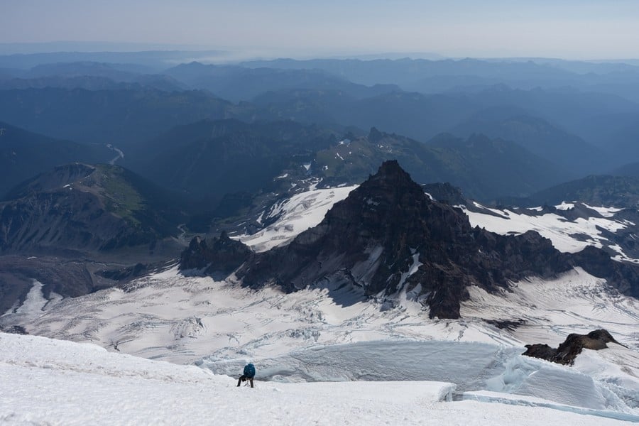
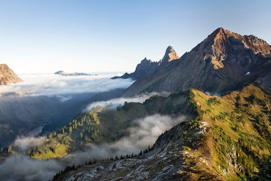
The High Cascades are newer volcanic mountains, formed within the last few million years. This section includes some of the range’s most famous and active volcanoes, such as Mount Rainier, Mount St. Helens, and Mount Hood. The High Cascades are known for their rugged terrain, glaciers and geothermal activity.
The Lower Cascades
The Lower Cascades are composed of older, less volcanic rock formations. The terrain here is generally less rugged and more forested, with lower elevations. These mountains serve as a transitional zone between the high volcanic peaks and the surrounding landscapes, They feature a mix of rolling hills and deep valleys.
Where Do the Cascade Mountains Start and End?
The Cascades begin at the Fraser River in British Columbia, Canada, and traverse south through the U.S. states of Washington and Oregon, concluding at Lassen Peak in Northern California.
How Did the Cascade Mountains Form?
The Cascade Range is the result of a collision between the Juan de Fuca Plate and North American Plate.
The denser, eastward-moving Juan de Fuca Plate is sinking below the lighter, westward-moving North American Plate. As the Juan de Fuca Plate descends, it encounters increasing temperatures and pressures 60 miles (97 meters) beneath the surface, causing the rock to melt and form magma. This magma rises to the surface, ultimately erupting as volcanoes.
The Cascade Range is essentially a chain of these volcanoes, marking the path along the subduction zone (where the Juan de Fuca Plate sinks beneath the North American Plate). These mountains have been forming over the past 36 million years, but the most significant volcanic activity occurred around 7 to 4 million years ago. This period of intense volcanism has resulted in the formation of Mount Rainier, Mount St. Helens, and Mount Hood, among others.
Glacial activity has also played a part in sculpting the landscape. During the last Ice Age, glaciers carved out valleys, shaped peaks, and left behind lakes. This interplay between fire and ice has created the Cascade Mountains.
Are the Cascade Mountains Part of the Ring of Fire?
Yes, the Cascade Mountains are part of the Pacific Ring of Fire.
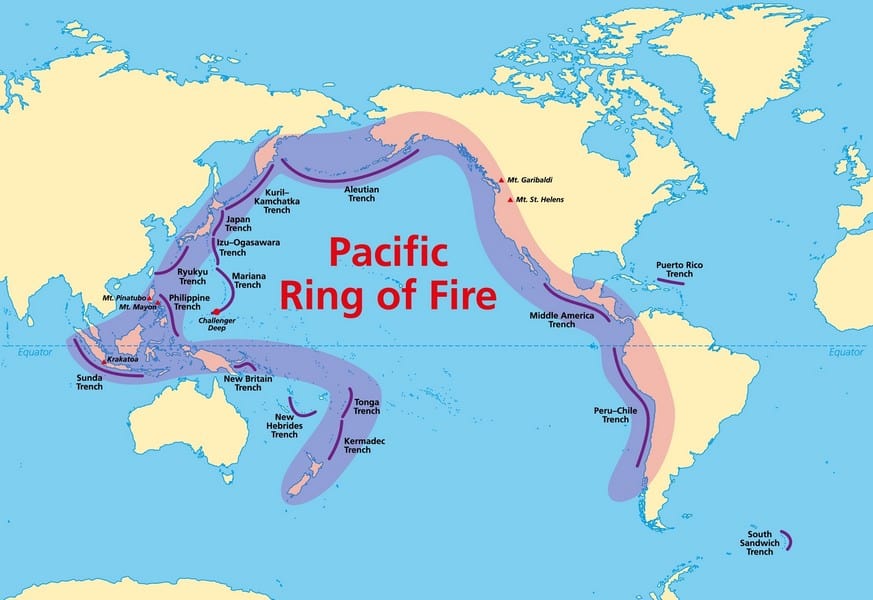
The Ring of Fire is a horseshoe-shaped zone that encircles the Pacific Ocean, characterized by a high frequency of earthquakes and volcanic eruptions. This nearly 25,000 mile (40,000 kilometer) arc is not a continuous line but a path marked by active and dormant volcanic structures, earthquake sites, and tectonic plate boundaries. It is home to about 75% of the world’s active and dormant volcanoes and accounts for approximately 90% of the world’s earthquakes!
The interactions of tectonic plates along the Ring of Fire pose significant risks to populations living in these regions. Major cities around the Pacific, such as Tokyo, Santiago, Los Angeles, and Manila, face hazards from both earthquakes and volcanic eruptions.
How Big and Tall are the Cascade Mountains?
The Cascade Range boasts several high peaks. Mount Rainier in Washington is the highest mountain in the Cascades, at 14,411 feet (4,392 meters) tall. The most popular peaks in the range are:
- Mount Rainier: At 14,411 feet (4,392 meters), Mount Rainier is the range’s highest peak and one of the most iconic mountains in the United States.
- Mount Shasta: This peak in Northern California stands at 14,179 feet (4,322 meters), making it one of the tallest mountains in the Cascade Range.
- Mount Adams: At 12,281 feet (3,743 meters), Mount Adams is a prominent stratovolcano in Washington State.
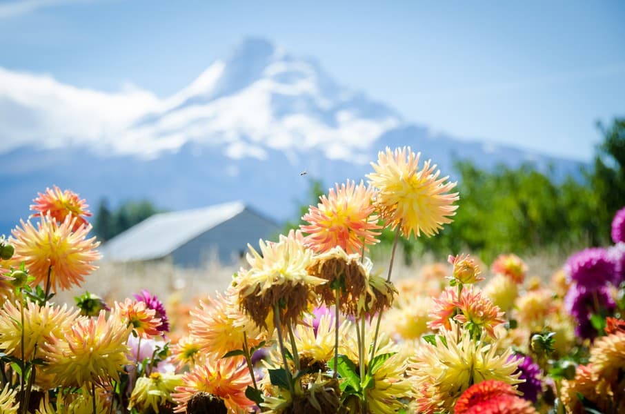
- Mount Hood: Mount Hood is an active stratovolcano and is Oregon’s highest peak, at 11,249 feet (3,429 meters).
- Mount Baker: With an elevation of 10,781 feet (3,286 meters), Mount Baker in Washington is an active volcano and popular alpine climb for beginners.
- Mount St. Helens: Famous for its explosive eruption in 1980, Mount St. Helens has a post-eruption elevation of 8,363 feet (2,549 meters), though it was significantly taller before its summit was blown off.
What are the Some Famous Features of the Cascade Mountains?
The Cascades are home to numerous landmarks:
- Crater Lake: A deep lake formed by the collapse of Mount Mazama, known for its deep blue color.
- Columbia River Gorge: A scenic canyon forming the border between Oregon and Washington.
- North Cascades National Park: Known for its rugged terrain and alpine landscapes.
- The Enchantments: Features granite basins, sparkling alpine lakes, and golden larch trees in autumn.
- Smith Rock State Park: A global climbing destination with towering volcanic ash spires.
- Three Sisters: Distinctive volcanic peaks offering climbing experiences.
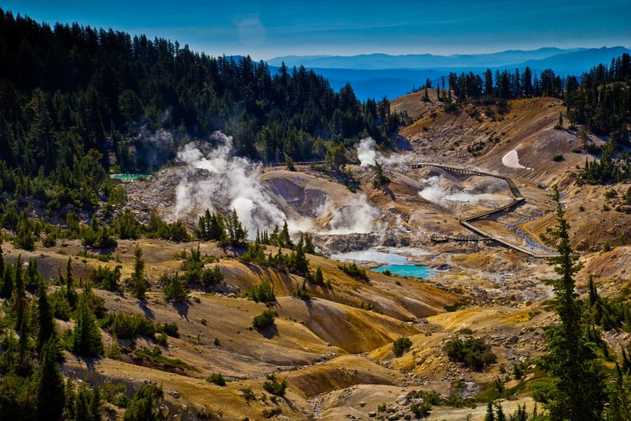
- Lassen Volcanic National Park: Showcases all four types of volcanoes, with thermal wonders.
- Silver Falls State Park: Oregon’s largest state park, famous for the Trail of Ten Falls.
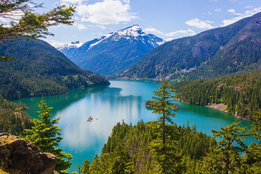
- Lake Chelan: A long, narrow lake, one of the deepest in the U.S., offering scenic drives and ferry rides.
What are Notable Hikes in the Cascades?
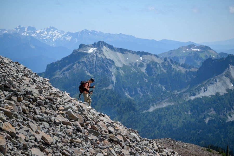
The Cascades offer a wide variety of hikes:
- Skyline Trail Loop, Mount Rainier National Park: A scenic 5.5-mile loop offering stunning views of Mount Rainier, wildflower meadows, and the chance to spot wildlife. Suitable for most ability levels.
- Cascade Pass, North Cascades National Park: This moderate, 7.4-mile round trip hike provides views of jagged peaks and glaciers. It’s an excellent introduction to the alpine landscape of the North Cascades.
- Colchuck Lake, Alpine Lakes Wilderness: A challenging but rewarding 8-mile round trip hike to one of the most beautiful alpine lakes, framed by dramatic peaks. The trail offers a glimpse into the heart of the Cascades.
- PCT: Stevens Pass to Snoqualmie Pass: A segment of the Pacific Crest Trail covering approximately 71 miles of diverse landscapes. Ideal for experienced hikers looking for a multi-day adventure.
- Mirror Lake Loop, Mount Hood National Forest: A family-friendly 4.2-mile loop around Mirror Lake with reflections of Mount Hood. This trail is popular for its accessibility and picturesque views.
- Eagle Creek Trail to Punchbowl Falls, Columbia River Gorge: A moderate 3.8-mile round trip hike famous for its waterfalls, especially Punchbowl Falls. The trail is part of the larger Eagle Creek Trail system.
- Sauk Mountain Trail, Mount Baker-Snoqualmie National Forest: A moderate 2.5-mile trail that switchbacks up Sauk Mountain, offering panoramic views of the Skagit Valley, the Cascade Range, and the San Juan Islands.
- Enchantments Core Zone, Alpine Lakes Wilderness: A strenuous, 18 to 20-mile through-hike through one of the most spectacular alpine landscapes. This hike requires a permit.
- Goat Lake, Henry M. Jackson Wilderness: A moderate, 10.4-mile round trip hike to Goat Lake, where hikers can enjoy views of waterfalls with a mountain backdrop.
- Mount Constitution Loop, Moran State Park, Orcas Island: Although not on the mainland, this 6.7-mile loop on Orcas Island offers one of the best views in the Pacific Northwest from the top of Mount Constitution, overlooking the San Juan Islands.
What is the Weather Like in the Cascade Mountains?
The Cascade Mountains experience a diverse climate, largely influenced by their elevation range and proximity to the Pacific Ocean. This variability in weather patterns makes the Cascades a region of contrast and beauty, where conditions can shift dramatically from one area to another.
Spring: The season brings melting snow at lower elevations and a resurgence of flora and fauna. Higher elevations remain snow-covered. Temperatures range from lows of 30°F (-1°C) to highs of 60°F (15°C) in the foothills.
Summer: July through September is the driest and warmest period, with temperatures in lower areas reaching up to 80°F (27°C) during the day but cooler in the evenings. At higher elevations, the weather remains milder, making it an ideal time for hiking and mountaineering.
Autumn: Cooler temperatures return, and the landscape becomes a canvas of vibrant colours. Early snowfalls can occur at high altitudes. Temperatures start to drop, ranging from 40°F (4°C) to 70°F (21°C) in September and becoming progressively cooler.
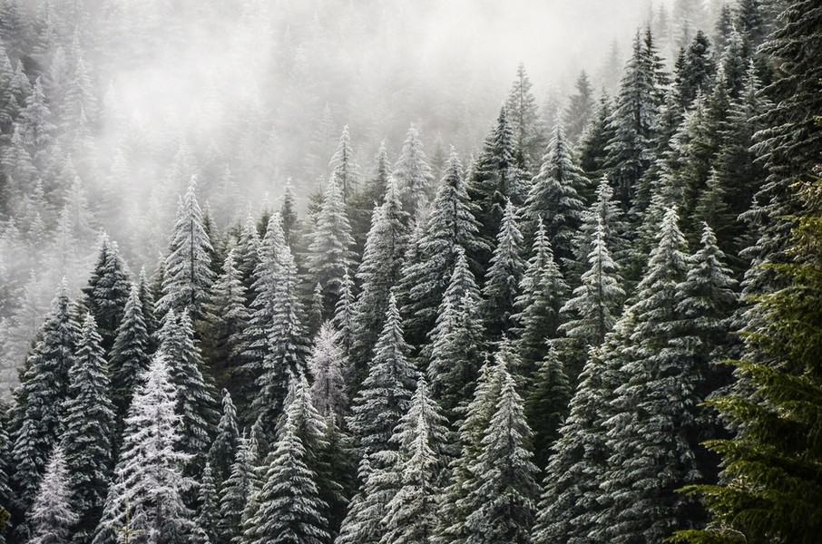
Winter: The Cascades are known for heavy snowfall, especially at elevations above 4,000 feet (1,219 meters), where it can accumulate to several feet. This makes the region a premier destination for winter sports. Temperatures can fall below freezing, especially at night, and even reach sub-zero at the highest elevations.
The best time to visit the Cascade Mountains largely depends on the activities one intends to pursue.
Spring and summer offer the best opportunities for observing the Cascades’ wildlife and flora. Wildflower meadows are in full bloom from late spring through early summer. This is also when many animals are most active, with newborn wildlife emerging and migratory birds present.
For hiking, climbing, and camping, summer provides optimal conditions, with most trails snow-free and accessible. For winter sports like skiing and snowboarding, the months from December to early March offer deep snowpacks and excellent conditions. Autumn is ideal for those seeking to experience the fall foliage and cooler, but not yet cold, hiking conditions.
What Animals Can Be Found in the Cascade Mountains?
The habitats of the Cascades support a varied animal population.
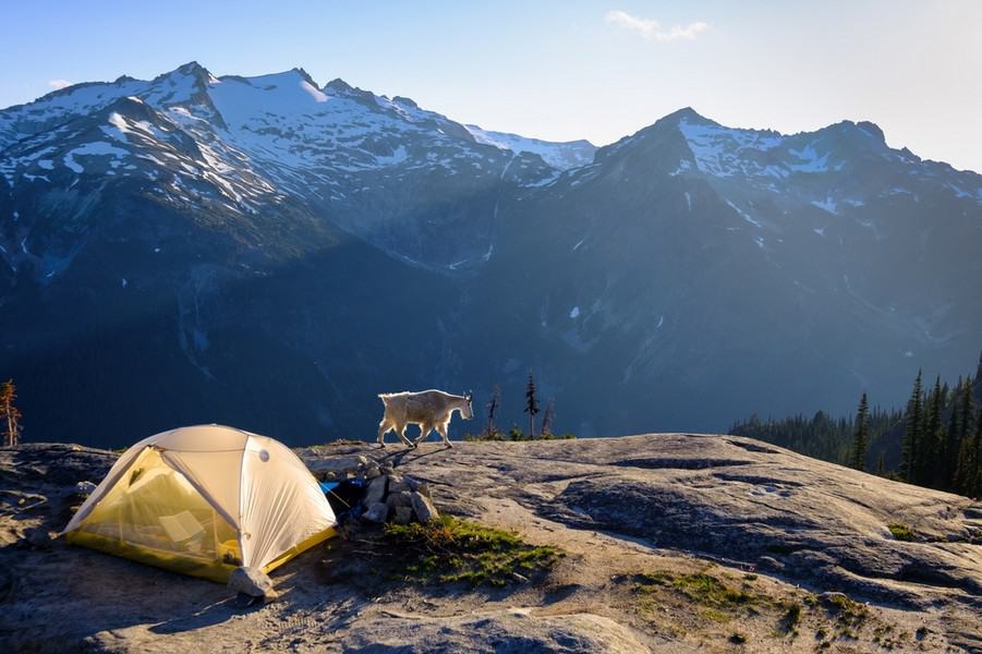
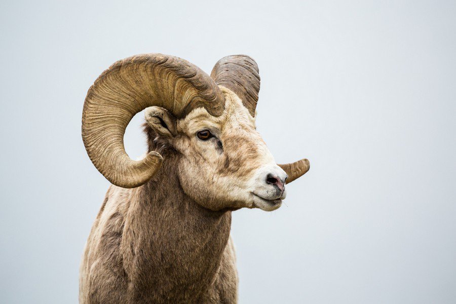
The alpine and subalpine zones host mountain goats, American pika and the hoary marmot. The dense forests at lower elevations provide shelter for grizzly bears, black bears, cougars, elk, red fox, and deer. Smaller mammals, such as raccoons, beavers, wolverines, and numerous rodent species, are also common, as are many bird species, including bald eagle, osprey, peregrine falcons, and the spotted owl.
Rivers and streams throughout the Cascades are teeming with life, notably salmon and trout, which undertake significant migrations to spawn.
Plant life ranges from dense coniferous forests on the western slopes to alpine meadows blooming with wildflowers in the higher elevations. Old-growth forests with Douglas fir, western red cedar, and hemlock dominate the landscape.
Who Lived in the Cascade Mountains?
Before European settlement, various indigenous groups inhabited the Cascade Range. Among the prominent groups are the Coast Salish, Nuu-chah-nulth, and Chinook along the western slopes, and the Klickitat, Yakama, and Warm Springs tribes who inhabit regions east of the Cascade Range. The Tulalip Tribes, residing near the Puget Sound area north of Seattle, have ancestral ties to the western foothills of the Cascades. They, like many other groups, have maintained a deep spiritual connection to this mountainous terrain, relying on it for food, medicine, and materials for tools and housing.
European arrival in the 18th and 19th centuries marked a period of upheaval for these communities. The establishment of trade routes, mining operations, and settlements led to land dispossession, altered landscapes, and the introduction of diseases. Treaties were negotiated, often under duress, leading to the ceding of vast tracts of land and the establishment of reservations.
Today, indigenous peoples of the Cascade region continue to advocate for their rights, cultures, and stewardship of the land. They are involved in environmental management, restoration projects, and cultural revitalisation efforts, ensuring their traditions and knowledge are passed down to future generations.
")


")
")