
Ultimate Kilimanjaro® is an authoritative expert in the industry.
Because of our reputation as the #1 guide service on Mount Kilimanjaro, we are cited in the media on a regular basis. Additionally, our clients have been featured everywhere – magazines, television, newspapers, books and movies – and have included everyone – children, seniors, those with disabilities, charity climbers, celebrities, film makers, senators, ambassadors, authors and journalists.
If your story is reported, please let us know! We love seeing our clients in the media!
ULTIMATE KILIMANJARO CLIENTS FEATURED IN POWELL TRIBUNE
October 29, 2024

Visions from the Cradle of Humankind
by Mark Davis
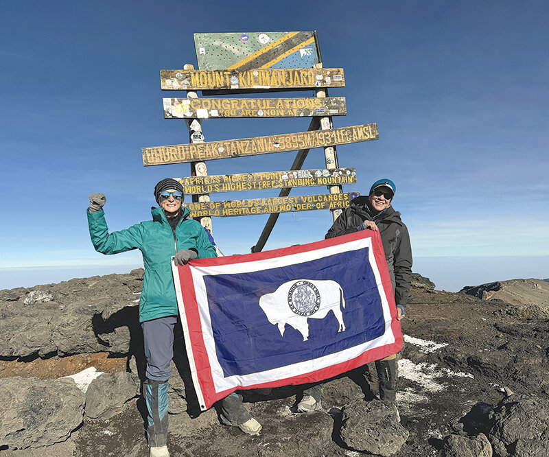
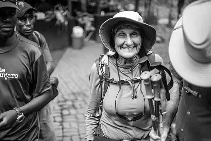
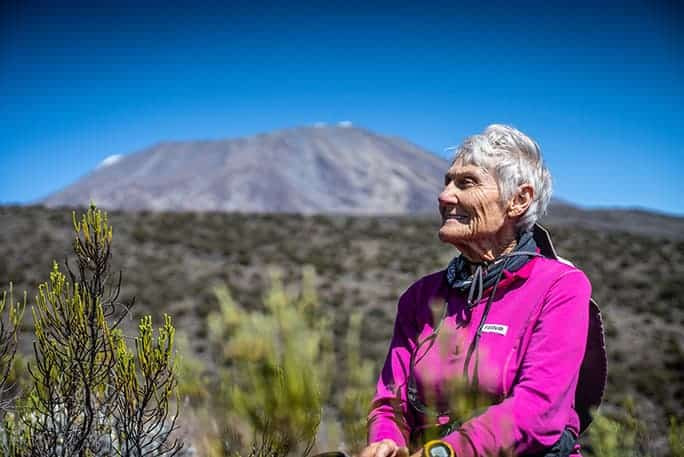
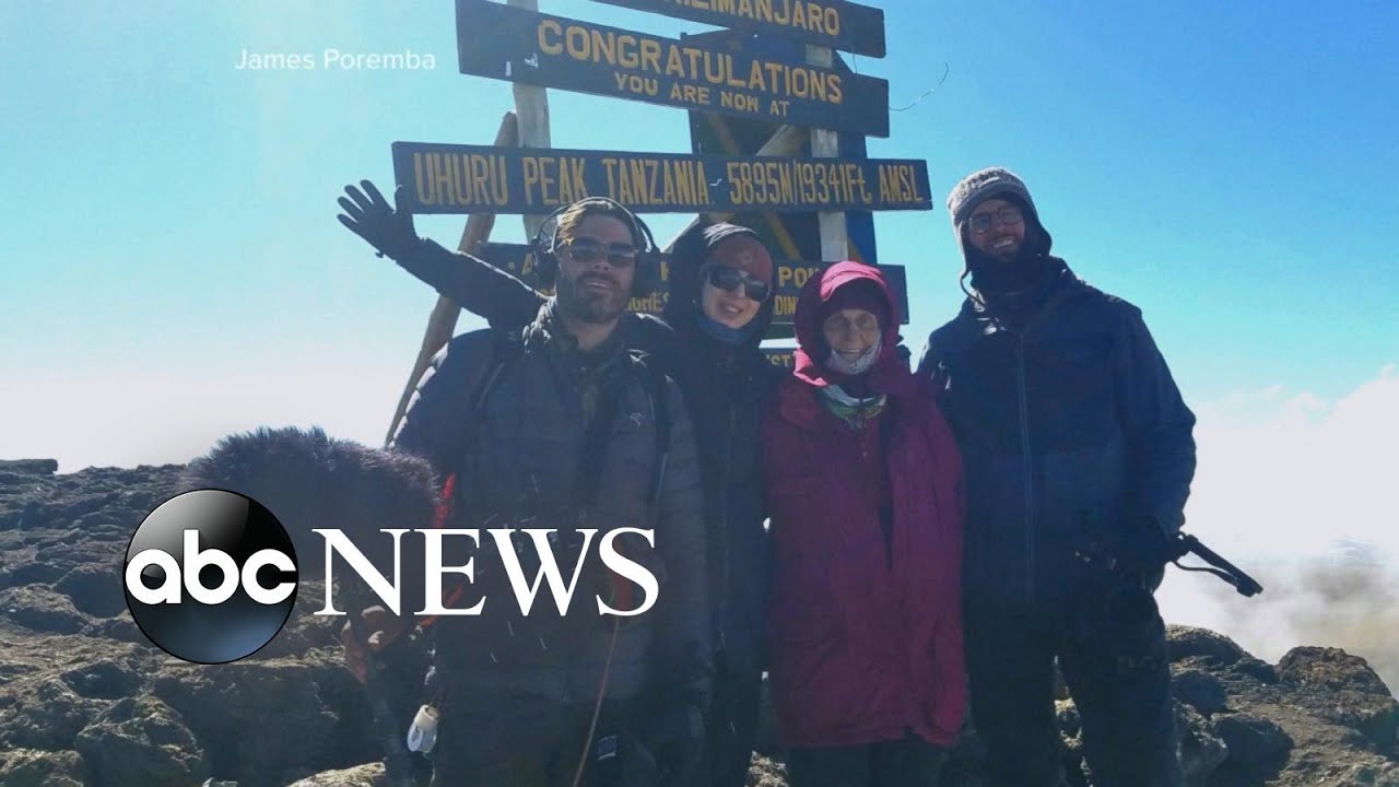
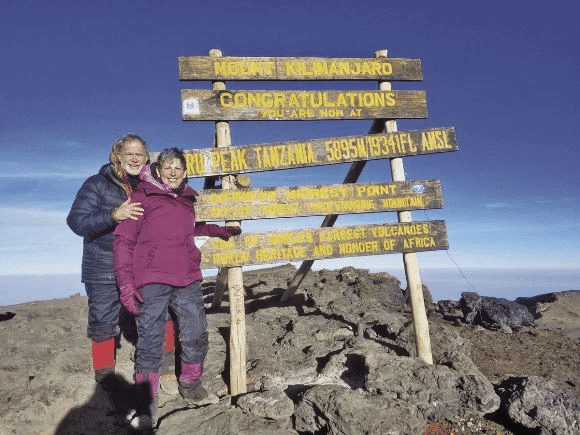
Step after step while climbing Mt. Kilimanjaro, the endeavor by area residents Deb White and Cathy Blanchard was as much mental as it was physical. For nine days the retirees pushed toward the summit on the mountain with the world’s fourth highest vertical climb, cementing a lifelong bond through their adventure on the 19,340-foot behemoth.
“I had never been tested to the full extent of my physical and mental capabilities,” said Blanchard, a 70-year-old making her home in the shadow of Heart Mountain.
It helped she knew her partner White, a former Cody High School science teacher, was an experienced climber and adventurer in Africa. They spent more than a year preparing themselves physically through workouts with Powell High School graduate and former Olympian Jesseca Cross, who is now a physical trainer in Cody, and long days hiking on Heart Mountain. Some thought their preparations were “insane.” Yet, Blanchard and White never let criticism stop them from pushing their way to the top.
Through long, cold nights and the struggles of even longer days wending their way through the jungle, past the tree line and toward the snow-covered peak, the duo inspired each other on the epic journey. During the first couple days, the group of strangers being guided to the top blissfully chatted. But as the trip began to grind on their bodies it became a mind game and they continued for days in silence.
“We’ve had a lot of time alone in our heads,” White said. “No news or politics; we were just in survival mode.”
Blanchard made her way up the mountain on those days of silence by meditating and chanting. Both counted their steps to get into a rhythm of the seemingly never-ending ups and downs. There were days where they worked hard from sun up to sun down, yet the summit seemed just as far away as when they started.
While in her head, Blanchard had a vision of her mother Millie Peterson Richmond holding her as an infant.
Visions from the cradle
“It’s funny what goes through your head,” Blanchard said.
It took her a minute to compose herself as she recounted the emotional experience.
“I had a vision of [my mother] holding me as a baby, and her looking down and saying or thinking to herself, this little girl is going to grow up to be a woman who is going to climb a big mountain in Africa,” she said, while wiping tears from her eyes.
It was not lost on her that she had a vision of her mother, who died on Christmas Day in 2023, while hiking through the “Cradle of Humankind,” as the continent is called due to evidence that human life originated in Africa.
The climbing partners never had an argument during the entire trip, they swore, as they endured the heat of the jungle to freezing weather on the mountain. There was some ribbing by Blanchard about the cold to her new friend who suggested the adventure.
“I would often poke her at night in the tent and I’d say, do you remember me telling you I hate to be cold?” Blanchard said. “We’d sleep with like, two coats on.”
Their porters would bring them hot water bottles after dinner, but it wasn’t enough to warm the pair during the uncomfortably cold nights in the mountains. But sleep was important in preparing for the next day and they had to force themselves to close their eyes.
“We slept really well the whole trip,” White said. “We were exercising so much that, all we did was eat and sleep and walk.”
The summit
On the final days of the trip the climbers only had time for a “nap” as they had to begin the final ascent to the summit at 10 p.m. to be able to get to the top of the peak before quickly descending the mountain before night set in.
It was an emotional moment at the top as the two unfurled a Wyoming state flag at the summit to honor their home while at the top of “the roof of Africa,” as the mountain is called by locals. Yet, they didn’t shed tears during the short celebration at the summit.
“I didn’t cry because it was too cold,” Blanchard said, remembering at the time that the two friends were a team, and “it took a whole team to do it,” she said.
White said that once they were at the end of their trip, when their porters sang a song to them to say goodbye, the tears began to flow. After the ceremony, each climber offered tips to the employees (about $300 in tips per climber) and gave them their coats and boots to help support them in a career that is extremely tough on garments and footwear.
The outfitters
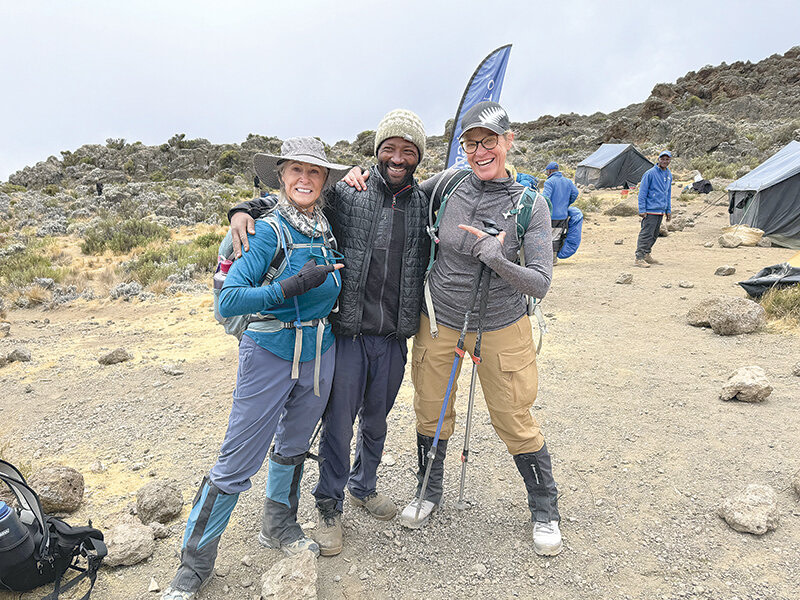
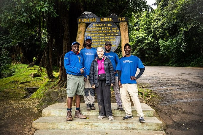
Both Park County adventurers praised their support staff. Their personal porter, who did everything from setting up their tent to discreetly attending to their bathroom needs in camp, looks strikingly like musician John Legend. The 12 climbers would move to the margins of the passageway while porters quickly raced by, loaded down with the camp and provisions to be ready to receive the group when they stopped for lunch and arrived at camp for the night.
Traversing a historic passage in elevations between 7,000 feet in the jungle and reaching 15,000 feet by day, they traveled in a group of 12 climbers, six guides and 40 trail-hardened porters employed by outfitter Ultimate Kilimanjaro. The company was started by former Chicago financial markets professional Kevin Hwang, who was inspired by his experience climbing the giant in 2006 and his love for Tanzania. Hwang quit his corporate job to build the outfitting company on the mountain, aiming to provide a safe, affordable journey that is fair to both adventurers and employees.
“I wanted to present the most complete, honest and accurate information on climbing Kilimanjaro (which was severely lacking at the time). I wanted to provide the best service, on and off the mountain,” Hwang wrote in his essay on starting the company.
The company is among 10% of outfitting companies on the mountain that have signed a pledge to pay their guides and porters a fair wage and supporting the Kilimanjaro Porters Assistance Project.
“Climbing Kilimanjaro is a team effort,” said Adam Collins, expedition coordinator for Ultimate Kilimanjaro. “Without guides and porters, there are no clients, there are no operators. It’s in our best interest to see that everyone is treated fairly.”
Blanchard and White said it’s important to seek out environmentally and financially ethical outfitters.
“I can’t say enough good things about the company, because it seems like there are some companies that are definitely less ethical,” she said.
Tourist climbers and the jobs created by visitors is extremely important to Kilimanjaro’s gateway communities, she said. The number of climbers has been increasing in the past two decades. Around 30,000 to 50,000 people climb Mount Kilimanjaro each year.
Some have said tourism is loving the mountain to death. However, the porters employed by Ultimate Kilimanjaro carry garbage bags to collect litter from those traveling with other less environmentally friendly guide services.
Next steps
While the adventure was inspiring, neither White nor Blanchard want to go again: They have their sights on new adventures — maybe in New Zealand — or a place they have yet to find on the map. No matter where they travel, they will go as best friends and guided in spirit by the words of former first lady Eleanor Roosevelt: “You gain strength, courage and confidence by every experience in which you really stop to look fear in the face. You must do the thing you think you cannot do.”
White and Blanchard survived the exotic adventure, finally celebrating with a glass of wine on a layover in London, and it has brought them closer.
“We will be friends and she will be in my life until the end,” Blanchard said.
ULTIMATE KILIMANJARO CLIENT BREAKS GUINESS WORLD RECORD
November 14, 2019

How Anne Lorimor climbed Mount Kilimanjaro at 89
by Rachel Gluck
Anne Lorimor is living proof that age is just a number. While many look forward to peace and quiet at the age of 89 years old, Anne is climbing exotic mountains that tower over 15,000 ft. As the world’s oldest woman to climb Mount Kilimanjaro, she embodies the exciting theme “Spirit of Adventure” for this year’s GWR Day.
While many might question how Anne managed to achieve such a feat at a wiser age, her story goes back decades. It was in 2004 that Anne Lorimor decided she needed to pay it forward.
She began working tirelessly to help underserved children and youth across the country by starting her own charity, Creating Exciting Futures.
As a young child born during the Great Depression and the oldest of ten children, Anne’s life was anything but easy, though her family never lost hope. After completing middle school, Anne graciously accepted help from her second-grade teacher who paid for her to attend a boarding-school in California.
As a result, Anne became an RN, completed two bachelor’s degrees, two master’s degrees, and even received her PhD in Communications. Anne’s teachers and mentors empowered her to achieve her dreams and she in turn wanted to do the same. So, she decided to combine her love of hiking and helping others by attempting a record to raise money and bring awareness to her cause.
To her, age is just a number, so at 76 she climbed Pikes Peak and four other mountains over 14,000 ft. She also climbed mountains in the western United States and Mexico, the Ayers Rock in Australia, the Great Pyramid in Egypt and the pyramid in Mexico City. After living in New Mexico, Anne couldn’t even remember a time where she did not hike.
Then in 2019, she decided to continue her journey by being the oldest person to climb Mount Kilimanjaro (female) and (overall) at 89 years and 37 days. This difficult journey was not lost on Anne as she previously hiked Mount Kilimanjaro, which is a dormant volcano in Tanzania. It also happens to be the highest mountain in Africa, at about 16,100 ft from its base to 19,341 ft above sea level.
Anne knew her age would not limit her and would be enough to break the previous record, which was held by Angela Vorobeva of Russia and achieved at 86 years and 267 days on October 19, 2015.
Anne says that it is important to be fit in mind, body and spirit. She set a plan and didn’t let anyone, or anything interfere! In order to physically prepare for her attempt, Anne hiked in Northern Arizona almost every day. She also hired a personal trainer for eight months to help increase her core strength.
However, after officially consulting with Guinness World Records about her attempt, Anne needed to ensure that she had a plan to help her break the record and follow the guidelines. These included hiking without any physical assistance as well as GPS tracking to ensure she reached the required mileage. Unfortunately, ahead of her official attempt, she broke her ribs, but thankfully was able to overcome the pain through prays and deep breathing.
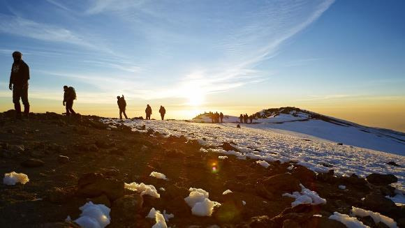
On July 12, 2019, Anne along with seven others scaled Kilimanjaro on the Rongai Route, which is the only route that approaches the mountain from the north. The complete trip from base to summit to base took nine days and they even did a special celebration dance when they reached the summit.
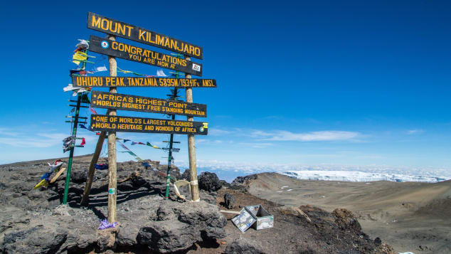
Finally, on July 18, 2019, Anne reached the Uhuru Peak, where she was able to see the snow cap mountains, the actual curvature of the earth but the most exciting was having her nephew announce that she was the official record holder. She completed her journey unassisted, with no oxygen or artificial aids.
Though Anne is not done yet! She still has her sights on hiking Machu Picchu, the Appalachian Trail and the Pacific Coast Trail. Anne says, “I’ve always had an adventurous spirit and a willingness to take risks. This experience was a great adventure!”
ULTIMATE KILIMANJARO FEATURED IN CNN TRAVEL
November 29, 2019

World’s Highest Mountains – and Size-Isn’t-Everything Alternatives
by Jordan Rane
Simply finding the Seven Summits — the highest mountains on each continent — is a tall order.
Let alone measuring them all to within a few frustratingly ever-evolving feet, naming them after rock star 19th-century British colonial land surveyors and Polish-Lithuanian generals — and, get this, risking limb and life-savings to climb them all because, well, they’re there.
Stark, scary, seductive, forever inscrutable, the Seven Summits and countless viable alternative peaks to “conquer” say far more about humans (basically that we have far too much time on our hands) than we ever will about them.
(excerpt)
AFRICA
MOUNT KILIMANJARO
Elevation: 19,340 feet
Location: Northern Tanzania
Even for a lone cone as spectacular as this jumbo geological marvel plunked in the East African plains, how does even the coolest-looking, -sounding, -residing mountain retain its rightful mystique once the annual climber rate surpasses the 50,000 mark?
Probably just by being Kilimanjaro — the world’s tallest freestanding peak, a dormant (but still simmering) volcano, and a not-so-microcosmic world unto itself.
Meandering through numerous ecological zones (tropical rain forest, heath, moorland, alpine desert, etc.) from savanna to snowcapped summit, hardy climbers here might be fooled into thinking they’re tromping across half the planet. But that would be too easy.
Reach for the top: A non-technical “walk up” climb with several established routes to choose from, Kilimanjaro is far too susceptible to being minimized as a multi-day hike. Reality check: Less than 30% of climbers manage to complete the entire journey on the most popular 5-day Marangu “Coca-Cola” Route plan, according to local guide service Ultimate Kilimanjaro.
A better bet: Losing the hasty crowds and adding a few extra days of acclimation on one of the longer, slower, undulating routes to combat altitude sickness — the main reason hikers bow out here.
Dry season (late June to October) is the preferable time to tackle Kilimanjaro, with September being the prime climbing month. Permits are essential to enter the park, and all climbers must use a guide and porters.
Marvel from below: Summit fever aside, don’t forget where you are — in prime African safari territory. Making time to see the Big Five and other amazing creatures in nearby Serengeti National Park and Ngorongoro Crater is a rivaling high point during any Kilimanjaro climbing expedition. Many guide services can build these visits into the itinerary.
Alternative alp (for road-less-taken types): Mount Kenya (17,057 feet). Far from the Kili crowds and less than 100 miles from Nairobi, Africa’s almost-famous, second-highest mountain occupies its own national park — frequented by savvy African peak baggers seeking a quieter, cheaper and reputedly an even more picturesque climbing experience.
ULTIMATE KILIMANJARO® GUIDES OLDEST PERSON TO THE SUMMIT – BREAKS WORLD RECORD
July 26, 2019

89-Year-Old Anne Lorimor Becomes Oldest Person to Climb Mount Kilimanjaro
by Alexandra Svokos
Anne Lorimor wasn’t willing to let go of her title without a fight.
The Arizona woman had climbed Tanzania’s Mount Kilimanjaro, the tallest freestanding mountain in the world, a few years back, according to Phoenix ABC affiliate KNXV, becoming the oldest woman to summit it at 85 years old.
And things were all well and good with that accomplishment under her belt.
But then she found out that another, older woman climbed the 19,341-foot peak, and that a man held the record for oldest person to climb it.
So this month, at 89 years old, she returned to Tanzania — and got back home to Arizona this week with a new title: the oldest person to summit Mount Kilimanjaro.
“There was a point when I really was concerned because I fell before I started up the mountain,” Lorimor told KNXV. “I had great pain in my side, and I couldn’t take deep breaths. I was afraid if I couldn’t keep oxygenated enough, I couldn’t go.”
Nevertheless, she persisted, making the trip in nine days.
Lorimor, a former university instructor, founded the organization Creating Exciting Futures in 2004 to support under-served children. Although not a professional climber, Lorimor has “enjoyed hiking most of her life,” according to the organization’s website.
The website says she aimed to set the world record on Kilimanjaro “to benefit children and youth through building her foundation.”
“If I combine my love of climbing mountains with my passion for helping kids, what could be better?” she’s quoted as saying on the site.
While Kilimanjaro is the tallest mountain in Africa, it is largely a non-technical climb, allowing for people of many different abilities to reach the summit.
Yet the mountain still presents considerable challenges, mostly due to its altitude. The climb demands that hikers take their time to acclimatize, and often stretches hikers’ physical and mental abilities to reach the magnificent top.
ULTIMATE KILIMANJARO® MENTIONED IN FORBES
Feb 19, 2019

Three Interesting Weather-Related Lessons From ‘Black Panther’
by Marshall Shepherd
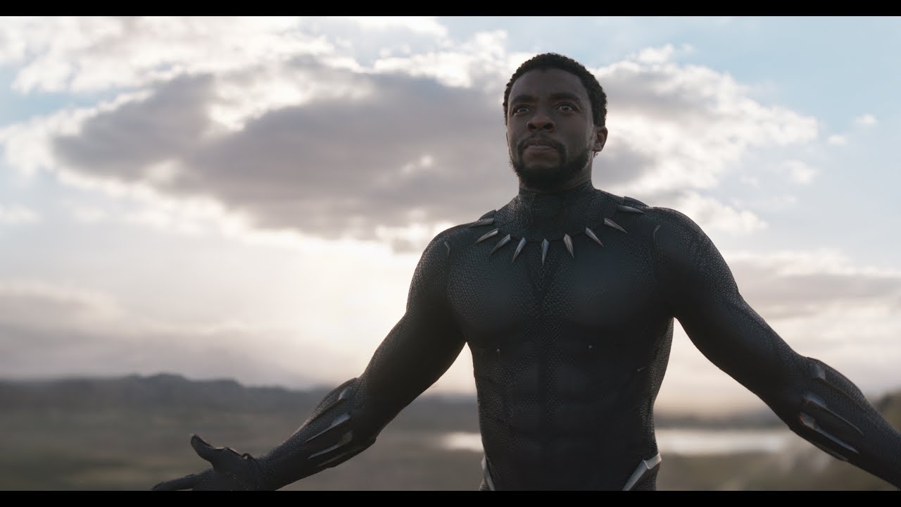
My family and I saw the movie Black Panther this weekend, and apparently, much of the United States did too. Reports in Forbes say that several box office records were shattered by the movie. As a long time fan of the Marvel genre of movies, I was very excited to see the next entry in the series. It was cinematically stunning, action-packed, and unique in its focus on the continent of Africa and its people. I thoroughly enjoyed the movie, but as usual, I always notice things in movies that the average viewer probably does not. As a meteorologist, professor, and director of the University of Georgia’s Atmospheric Sciences program, there were three teachable moments about the weather that caught my eye.
The snowy home of the Jabari Tribe. In Africa?
In the movie, the Jabari tribe of Wakanda lived in the mountains. The leader M’Baku and his troops end up being a very important element of the movie. At one point, some of the main characters venture into the territory of the Jabari tribe, and it is very snowy. Some viewers may be puzzled by snow in parts of tropical Africa, but it illustrates something that meteorologists are very familiar with. Temperature decreases with elevation, and snow is often present on mountains even in tropical regions.

Let’s consider a place that is not fictional. Mt. Kilimanjaro is located very close to the equator (approximately 3 degrees South) in Tanzania. It is a dormant volcano that rises to 19,341 feet above sea level. According to UltimateKilimanjaro.com, it has five ecological zones: Bushland, Rainforest, Heath, Alpine Desert, and Arctic. The Alpine Desert and Arctic zones, according to the website, are described as follows:
“The Alpine desert receives little water and correspondingly light vegetation exists here. The temperature can vary from over 100 degrees F during the day to below freezing at night…… (The Arctic Zone is) characterized by ice and rock, there is virtually no plant or animal life at this altitude. Nights are extremely cold and the day’s unbuffered sun is powerful.”
Upslope flow causes precipitation and at the altitude of those clouds, it will typically fall as snowfall at certain elevations. By the way, have you noticed my use of altitude versus elevation? Elevation typically describes height above a fixed level (usually sea level) above the ground. Altitude is similarly defined as some height above a point in relation to the ground. However, there can be a subtle distinction. For example, the “mile high” city of Denver is at an elevation of 5280 ft. but a plane may be flying at an altitude of 5280 ft.
Aurora Borealis or Australis in Africa?
In one scene of the movie, I saw something in the sky similar to the Aurorae. According to NOAA’s Space Weather Prediction Center website:
“The Aurora Borealis (Northern Lights) and Aurora Australis (Southern Lights) are the result of electrons colliding with the upper reaches of Earth’s atmosphere. (Protons cause faint and diffuse aurora, usually not easily visible to the human eye.) The electrons are energized through acceleration processes in the downwind tail (night side) of the magnetosphere and at lower altitudes along auroral field lines. The accelerated electrons follow the magnetic field of Earth down to the Polar Regions where they collide with oxygen and nitrogen atoms and molecules in Earth’s upper atmosphere. In these collisions, the electrons transfer their energy to the atmosphere thus exciting the atoms and molecules to higher energy states. When they relax back down to lower energy states, they release their energy in the form of light. This is similar to how a neon light works. The aurora typically forms 80 to 500 km above Earth’s surface.”

The actual scene may have represented where T’Challa was in the world at the time (I honestly do not remember). However, I did wonder if it would be possible in Wakanda, a fictitious country located in East Africa according to the Marvel Atlas Number 2, to see Aurorae. Northwestern Kenya is where many have speculated that Wakanda would be located so it is probably not likely, but on particularly active events, the Aurora Australis might be seen in parts of South Africa.
The Sunsets.
In two pivotal scenes, the Wakanda sunsets are referenced as being particularly beautiful. I can certainly see how this might be the case. First, it is important to understand why sunsets appear as they do. As the sun descends beneath the horizon, the sunlight is traveling through much more of the atmosphere than it would be at high noon (see figure above). This causes the shorter wavelengths of light such as blue to be scattered out leaving only the longer wavelength oranges and reds.

However, the beauty of sunsets on the continent of African may also be enhanced by the juxtaposition of the atmospheric phenomenon and the natural landscape. In an African Geographic article entitled, “7 Reasons why Africa is best after sunset,” the writer states “As the sun sinks below the horizon, burning the sky red, pink and orange, you will find yourself with a refreshing drink in your hand, parked on the edge of a pan. Be still and watch as a herd of elephants come down to drink, reflect on your day in the wild as the shadows lengthen and the fiery sky darkens to mauve. The first stars appear, and the sky seems bigger than it does in the rest of the world. In Africa, you can see a sunset and believe you have just witnessed a miracle.”
ULTIMATE KILIMANJARO® RECOMMENDED IN THE AUSTRALIAN (AUSTRALIA)
Nov 21, 2017
Peru to Nepal: The Paths Less Travelled
by Mark Daffey
The rise in popularity of active travel, particularly along classic hiking routes, can result in overcrowding and inflationary permit fees, simultaneously repudiating what made them so appealing in the first place. Some trails, it’s fair to say, are being loved to death. But there are other options with the same end goal.
Mount Kilimanjaro, Tanzania (excerpt)
The summit of Africa’s highest mountain is accessible from all sides via eight routes. The oldest and most established is the Marangu Route, also known as the Coca-Cola Route since it’s the only one where trekkers can bed down in dormitory-style sleeping huts rather than tents. Because of its gentler gradient, the Marangu Route is considered the easiest to trek up and down, which many visitors choose to do, adding to its sense of overcrowding.
Better scenery lies along the western Lemosho Route, where fewer than half as many trekkers attempt to reach the summit. The trail crosses the Shira Plateau before merging with the Southern Route past Lava Tower and Barafu Camp and the minimum time required is six days, compared with five for the Marangu Route, partly explaining why this route has a higher success rate of climbers standing atop Kilimanjaro’s highest point, Uhuru Peak.
Try: Ultimate Kilimanjaro offers trekking on all Kilimanjaro routes. Highly recommended is an eight-day itinerary on the Lemosho Route, allowing two extra days for acclimatization. More: ultimatekilimanjaro.com.
ULTIMATE KILIMANJARO® CLIENT FEATURED ON WGN TV (CHICAGO)
Nov 20, 2017

Cancer Survivor Scales Mt. Kilimanjaro With Doctor Who Saved His Life
by Erin Ivory
CHICAGO — Four years ago, a local man was given a five percent chance of survival after he was diagnosed with pancreatic cancer. This month, he returned from climbing Mt. Kilimanjaro with the doctor who saved his life.
Ken Brown believes he is alive today thanks to Dr. Malcolm Bilimoria. Beating the cancer was their first uphill battle; the second was the highest free-standing mountain in the world, Mt. Kilimanjaro. The pair say as they scaled the 20,000 ft. climb together they found joy, not only in reaching the summit, but also in journeying there together.
“I shouldn’t have been here. I just spent six days getting to know the man who saved my life, and I just also had the opportunity to see sights no one else can see at night,” Brown said. “I feel like I can reach out and touch the stars.”
November is National Pancreatic Awareness Month. Ken Brown and Dr. Malcolm Bilimoria want people to know pancreatic cancer isn’t a life sentence and there are options to not only survive, but truly live.
ULTIMATE KILIMANJARO® CITED IN TRAVEL+LEISURE
June 6, 2017
Where to Go for a Thrill-seeking Adventure Honeymoon
by Stacey Leasca
Congratulations, you’re about embark on the most important life adventure of all: marriage.
The love you’re about to share with your new partner is without question a huge adrenaline rush, but, before you walk down the aisle and say “I do,” make sure to also plan the perfect honeymoon for you and your thrill-seeking better half to keep the wedding excitement going.
From jumping off bridges together, to getting face-to-face with the lions of Africa, and even testing the limits of your life-long love on a few mountains, we’ve compiled some of the best adventure-filled honeymoon destinations around the globe for you to explore.
Hike and camp on Mount Kilimanjaro (excerpt)
If you’ve got time while planning your wedding why not throw in a little altitude training too. Hiking Mt. Kilimanjaro in Tanzania isn’t for the faint of heart, but it will most certainly bring your new marriage even closer together and literally take your breath away.
Book your climb with Ultimate Kilimanjaro, which leads more than 150 climbs per year. The service, which bills itself as the number one trekking company in the area, will take care of your every need from gear to food and even private toilets along the way. The best times to climb, according to the company, are the region’s warmest and driest months: January, February, and September.
ULTIMATE KILIMANJARO® CLIENTS FEATURED IN THE ADVOCATE & DEMOCRAT
Dec 23, 2016

Reaching the Peak: Clevelands Hike Mount Kilimanjaro
by Jessica Kent
“Pole, pole!” [pronounced pole-ay, pole-ay]
Sweetwater City Attorney John Cleveland and his wife Arlene heard their guide say the phrase repeatedly.
Pole, pole translates to “slowly, slowly” in Swahili, the main language of Tanzania.
“One step at a time,” recalled Arlene Cleveland. “Don’t think about the mountain or how far away the top is. Just focus on the now.”
That now was Mount Kilimanjaro.
Determined
In February, the Clevelands were watching the movie “Everest,” when they wondered if they could attempt mountain climbing.
“Mountain climbing looked so challenging and rewarding,” said Arlene. “We knew we would never attempt Everest so we started digging around the high peaks that we thought we might have a chance of actually summiting.”
Thus began extensive Google research.
“We saw that Mount Kilimanjaro in Tanzania, Africa, seemed to be a possibility for us—at least it didn’t involve ice, ropes or ladders!” said Arlene.
Mount Kilimanjaro is the highest mountain in Africa and the tallest freestanding mountain on Earth, rising in elevation to 19,341 feet above sea level.
Arlene is 66 years old and has had an artificial knee for 10 years. John is 64 years old and has had knee surgery from a skiing accident 20 years ago.
“We are not athletes,” said Arlene. “But, we are just determined to enjoy our planet! The highest we had climbed was Mt. LeConte.”
For the next couple of months, the couple discussed the idea of trying Kilimanjaro while continuing to do a “tremendous amount” of research. Eventually, they discovered a company called Ultimate Kilimanjaro, who was able to answer most of the couple’s questions about the climb.
“We were definitely concerned about the number of people who developed high altitude pulmonary edema, how many people died, what the weather was like, how to pack for the climb, how to train for the climb—those were are main questions,” said Arlene.
The couple decided to “go for it.”
Training
In May, John and Arlene began training for an October summit. Arlene said they walked three to five miles each morning, and went to Sweetwater Fitness Center three days a week to use the Stair Master for 30 minutes, followed by arm, back, shoulder and leg exercises.
“We also loaded our backpacks and walked up and down the hill on Morris Street from Main to College Street six round trips,” she said.
And almost every weekend, the couple scouted out trails in the Cherokee Forest or the Smoky Mountains.
“I fell in love with the trails,” said Arlene. “Some of them were so hard, but we were back out the next weekend ready to tackle the next one.”
To get more prepared for their journey, the Clevelands contacted AltitudeTech in August and rented a plastic tent that fully encased the bed in their home, with zippers to get in and out, and an attached hose that pumped in diluted oxygen.
“Because Kilimanjaro is nearly 20,000 feet in altitude, there is a significant risk of developing altitude sickness and we wanted to acclimatize and hopefully not suffer from the altitude change,” said Arlene. “We set our nighttime oxygen level at 10,500 feet and each evening, we would wear a mask for about an hour with the altitude set at 20,000 feet. I tried to use the rowing machine while wearing the mask and lasted less than two minutes—any exertion at 20,000 feet was not going to happen!”
Two weeks before the couple were set to leave for Africa, Arlene fell down their steps and broke her right ankle.
“I lay at the bottom of my stairs for at least a half hour planning what to do if I had in fact broken my ankle,” said Arlene. “I decided that I was going up that mountain, regardless of whether it was a sprain or fracture.”
After X-rays at Sweetwater Hospital Association, Dr. Chris Bowman called Arlene into his office and told her that her ankle was broken. Sigrid Johnson, Arlene’s family doctor, had told Dr. Bowman about the Clevelands’ travel plans so he knew she wanted “fast healing.”
“He sent me to physical therapy and the therapists at Sweetwater Hospital had me working on different machines and techniques for strength and balance,” said Arlene. “Actually, John and I hiked Rocky Top a week after the break so my ankle was past the painful stage.”
The Challenge
On Oct. 7, the Clevelands got on a plane and headed for Africa. Two days later, the couple met their guides for the climb and on Oct. 10, they met the other 11 climbers who would be taking on the challenge of the Lemosho route with them.
“After a three-hour bus ride on unpaved roads, we got to the Londorossi Gate at 7700 feet and climbed for four hours,” said Arlene. “Our tent was set up when we reached camp, as it was every day we climbed, and a hot dinner was served in the mess tent.”
Arlene said they got to know the other climbers very well.
“We soon lost any aspect of modesty,” she laughed. “And made friends for life. They were from all over the world, and all were about 25 years younger than we are!”
There were four Tanzanian guides, and 36 porters who carried all the tents, equipment, and duffle bags, Arlene explained.
“Each climber was limited to 33 pounds in a duffle, and a porter would carry two of them, plus another pack on top of his or her head. and literally run up the mountain,” she said. “We carried our own backpack that contained four liters of water, rain gear—although it never rained, a fleece jacket, hat, and energy treats. We used trekking poles, which really helped.”
The Clevelands said the trails were extremely dusty, and if not dusty, full of rocks and boulders that had to be climbed.
“There were places where the trail was so narrow and steep that we had to ‘kiss the rock wall’ while holding on with outstretched arms and sliding our feet sideways to get past the bluffs,” said Arlene.
And, there were no showers.
“We took wet wipes, which were so cold in early morning, and we tried camping shampoo, which is awful,” Arlene laughed. “One of our porters was called the ‘toilet engineer,’ and we did have one portable chemical toilet surrounded by a 3’ x 3’ x 8’ tent. We lost all inhibitions!”
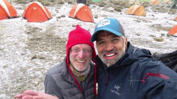
Twice a day, Arlene said their lead guide, Baraka, [“Everyone called him Mr. President,” Arlene commented] took the climbers pulse rates and blood oxygen saturation to make sure they could continue.
“John and my levels were always within a safe range,” she said. “Two people got sick and had to turn back in our group—one from Australia and the other from Argentina. Another young woman from D.C. got sick and vomited eight times, but she persevered. Neither John nor I felt sick or had any odd thoughts or feelings.”
Mount Kilimanjaro has five different ecological zones: bush land, rain forest, Heath, alpine desert and arctic. Therefore, the climate changes along the climb.
“The first two days, the weather was comfortable in the 70s. At night, it got cool,” said Arlene. “The Heath started getting colder, around the 50s during the day and the 40s at night. The alpine desert was cold—30s. We only went to the arctic when we summited and it was bitterly cold.”
Above the clouds
On the day the hikers summited, Oct. 16, it was a full moon. Guides awoke them at 11:30 p.m. and the climb began at midnight. The Clevelands were wearing six layers of wool and down, their headlamps, and foot warmers wrapped around their water bladders (a reservoir to hold your water while hiking or pursuing an outdoor adventure).
The temperature was hovering at 19 degrees Fahrenheit and winds were stiff at 10 miles-per-hour.
“We climbed for seven hours uphill until the sun rose and we were above the clouds!” said Arlene. “I cried. it was a magical moment! We saw 17-foot glaciers that were like monstrous icicles growing up of the mountain. Then, we were at the roof of Africa!”
Arlene said “sliding down” the mountain was scary and difficult.
“Kilimanjaro is a volcano and the route down is very different from the climb up,” she explained. “It is very direct, straight down. The trail is covered 8 inches deep in scree, dark gray dust and small rocks making it extremely slippery. We slipped and slid down the mountain. We made it down in less than three hours.”
The entire climb took a total of eight days with approximately 50 hours of actual hiking.
“Climbing Kilimanjaro is the hardest thing either of us have done. I would think that it couldn’t get any harder, and then it would,” said Arlene. “But, we did it. Maybe our expectations have changed to more of participants, rather than spectators..we’ll see.”
“People tell us they see us out walking, and that they should be out too. My message is ‘Do it!’” Arlene continued. “Most people can actually do whatever they attempt—with the right equipment and mindset. I am a real believer that everything is possible.”
The Clevelands’ next trip will be to the Outer Banks with their children, daughter-in-laws and three grandsons.
“After that, who knows?” smiled Arlene.
ULTIMATE KILIMANJARO® CITED IN INQUISITR
July 19, 2016

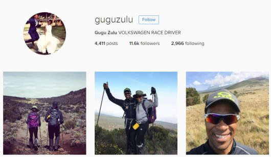
Nelson Mandela Day: South African Rally Driver Gugu Zulu Dies on Mount Kilimanjaro in Trek4Mandela
by Anne Sewell

The Nelson Mandela Foundation announced with a “heavy heart” on Monday the death of Gugu Zulu, one of the climbers on the Trek4Mandela team. The South African rally driver lost his life while attempting to climb to the summit of Mount Kilimanjaro in Tanzania. The climbers participating in the Trek4Mandela were due to reach the summit of Kilimanjaro on Monday, to celebrate Nelson Mandela Day. The aim of the climb was to raise awareness to the Caring4Girls sanitary pad distribution program.
Right at the start of the six-day hike, Zulu said he was “so honored to be part of this amazing positive initiative.”
On July 16, Zulu made his second to last post on his Instagram page: “Made it though [through] day2. My wife is doing fabulous, she has even learnt the local language. Am having flu like symptoms and struggling with the mountain but taking it step by step!! Today we managed to see our destination and our camp is literary [literally] above the clouds!! Bring day 3@@ #AdventureCouple #AdventureLiving#Trek4Mandela #Caring4Girls #Thule #Fitbit.”
In the South African rally driver’s last post to Instagram, he said: “Acclimatization day3 – just taking a stroll in the garden high above a blanket of clouds – amazing.”
In a press release, the Nelson Mandela Foundation said, “On behalf of the Board and staff of the Nelson Mandela Foundation we extend our sincere condolences to his wife Letshego Zulu, their daughter Lelethu and the Zulu family on this tragic loss.”
The press release went on to read that the details they had were “sketchy.” They did know Gugu experienced breathing problems on the mountain and that the medical team supporting the Trek4Mandela put Zulu on a drip before descending the mountain. Reportedly while the medical team did everything possible to save his life, Zulu passed away.
The statement continued, “Gugu was climbing Kilimanjaro with his wife Letshego and we understand that they both descended the mountain together with Richard Mabaso, the project leader and the medical teams. The team was led by experienced mountaineer, Sibusiso Vilane.”
As reported by Timeslive, Zulu complained of suffering from flu-like symptoms on Saturday and posted to his Instagram page that he was “struggling with the mountain.” While he continued walking the next day, it was hours later that he required medical treatment for breathing difficulties.
Although the cause of death has not yet been confirmed, according to climbing experts, Zulu most likely succumbed to altitude sickness, also known as pulmonary edema or acute mountain sickness, which is reportedly a common cause of death on high mountains.
Justin Lawson, a mountain guide for Climbing ZA, said, “Any such [flu-like] symptoms are a cause for concern whilst at altitude.”
“If you have symptoms of mild AMS (acute mountain sickness)‚ then you should not go any higher for 24 to 48 hours. If the symptoms do not improve or get worse‚ then you should descend immediately‚” he said.
Adam Collins, an expedition coordinator for Ultimate Kilimanjaro said Zulu should have turned around sooner. “However‚ it should be noted that it is very common for climbers to get symptoms associated with acute mountain sickness at some point during their climb‚” Collins added.
“So it is really a question of what degree of acute mountain sickness Zulu experienced‚ and what was done to prevent‚ identify‚ and treat altitude related illnesses‚” he said.

According to Collins, Mount Kilimanjaro is commonly described as being “Everyman’s Everest,” because it is one of seven summits that can be climbed by anyone who is reasonably fit and no technical mountaineering skills are required.
“However‚ at 5895m-tall‚ there is a high probability of developing some degree of acute mountain sickness while on Kilimanjaro,” said Collins, adding, “Therefore it is good practice for those wanting to climb Kilimanjaro to get cleared for high altitude trekking by their doctors.”
Collins went on to say there is always a danger when climbing high mountains and that approximately 10 out of 35,000 climbers die each year on the mountain, primarily due to acute mountain sickness.
Sello Hatang, CEO of the Nelson Mandela Foundation said, “I am devastated. I knew him well. I recruited him to climb Kilimanjaro. The last thing he said to me at the airport before he left last week was that he wanted to speak about doing other Mandela Day projects. I feel a huge sense of loss.”
According to Eyewitness News, Zulu’s sister, along with a representative from the Nelson Mandela Foundation were meeting doctors in Tanzania on Monday evening to establish the exact cause of his death. The Foundation is also working to repatriate Gugu Zulu’s remains back home to South Africa.
ULTIMATE KILIMANJARO® ASKED FOR EXPERT OPINION BY TIMES MEDIA GROUP (SOUTH AFRICA)
July 19, 2016

Gugu Zulu ‘Should Have Turned Back”, Experts Say
by Nomahlubi Jordaan
Gugu Zulu should not have continued his attempt to summit Mount Kilimanjaro after complaining of flu-like symptoms. Climbing experts told TMG Digital on Tuesday that flu-like symptoms were a cause for serious concern at high altitude.
Zulu died while taking part on the Trek4Mandela expedition on Mount Kilimanjaro. He complained of having flu-like symptoms on Saturday and posted on his Instagram account that he was “struggling with the mountain”.
The next day‚ he continued walking and was photographed getting acclimatised. Hours later he required medical treatment for breathing difficulties.
Climbing experts suspect that Zulu could have succumbed to altitude sickness – although the cause of death is yet to be confirmed – also known as pulmonary oedema‚ which they say is a common cause of death on high mountains. The Nelson Mandela Foundation said on Tuesday said that it did not have any details about the cause of death.
“Any such [flu-like] symptoms are a cause for concern whilst at altitude‚” explained Justin Lawson‚ a mountain guide from Climbing ZA.
“If you have symptoms of mild AMS (acute mountain sickness)‚ then you should not go any higher for 24 to 48 hours. If the symptoms do not improve or get worse‚ then you should descend immediately‚” he said.
“… he should have turned around sooner. However‚ it should be noted that it is very common for climbers to get symptoms associated with acute mountain sickness at some point during their climb‚” said Adam Collins‚ expedition coordinator at Ultimate Kilimanjaro.
“So it is really a question of what degree of acute mountain sickness Zulu experienced‚ and what was done to prevent‚ identify‚ and treat altitude related illnesses‚” he said.
“By mountaineering standards‚ this fatality rate is very‚ very low. Some peaks have 50% fatality rates‚” said Collins.
Edmund February‚ an ardent climber and an associate professor in the Department of Biological Sciences at the University of Cape Town‚ however‚ believes there could be more deaths on Kilimanjaro which go unreported.
“I would imagine it’s a lot more common than what comes out. Gugu was a famous guy that’s why we hear about it but I have heard of several deaths on Kilimanjaro.”
Lawson said that for anyone climbing a mountain above 1500m‚ care had to be taken to acclimatize properly by ascending slowly and descending immediately if one showed any signs of acute mountain sickness. “The more days you allow climbing the mountain‚ the higher the probability of success as your body has more time to adapt and acclimatize‚” he said.
ULTIMATE KILIMANJARO® FEATURED IN WEDDING INSPIRATIONS MAGAZINE
June 9, 2016

The Road Less Travelled
by Andre Fiore

You’ve successfully navigated your special day and made your forever vows. Now why not mark the start of a lifetime of memories together with a bucket-list adventure? There’s no time like the present to throw caution to the wind and set your souls alight
You’ve successfully navigated your special day and made your forever vows. Now why not mark the start of a lifetime of memories together with a bucket-list adventure? There’s no time like the present to throw caution to the wind and set your souls alight!
CLIMB MOUNT KILIMANJARO
You’ll most certainly feel on top of the world as you and your number one mate summit Mount Kilimanjaro. The world’s tallest free-standing mountain at 5 895m, and the highest mountain in Africa, a ‘quick’ trip up is the ultimate addition to any Tanzanian honeymoon. Its majestic peak permanently covered in snow and its three dormant volcanic cones, Kibo, Mawenzi, and Shira, make for a heady mix.
Your quick trip will take between five and nine days on average, depending on a number of factors such as weather, your state of fitness, acclimatisation and the route you choose. There are seven well established routes to the summit which vary in degrees of difficulty as well as in type of accommodation (they range from camping only to huts and electricity in some places). Despite the dramatic mountainscapes, rocky formations, beautiful forests and spectacular ridges, climbing Kili is no walk in the park and travellers are advised to research thoroughly, use an established and reputable company, and prepare properly in every way. SA-based company Climbing Kilimanjaro has ticked off over 15 000 successful summit attempts since 1994, and offers hikes up Mt Meru, Mt Kenya, and active volcano Mt Ol Doinyo Lengai. Ultimate Kilimanjaro is also worth a thought.
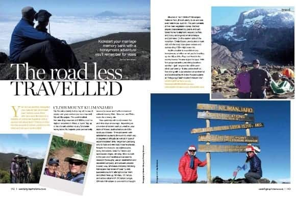
Situated in the 1,668km² Kilimanjaro National Park, there’s plenty to do and see even before you summit. The park consists of five main vegetation zones, the foot slopes characterised by plains and lush forest home to elephant, leopard, buffalo, and many endangered small antelope and primates. On the eastern side of the mountain, Chala Crater Lake is also a mustvisit with its deep blue-green waters and surrounding 100m high crater rim.
Acclimatisation is essential on any honeymoon, whether or not you’re heading up the hill, and the Bay Leaf Hotel in the nearby town of Arusha is just the spot. With five gorgeous suites promising luxurious comfort – just the place for a little postclimb pampering – it also prides itself on fine dining with a combination of continental and traditional North Indian Punjabi cuisine, an “intriguing match-made-in-heaven mix”.