

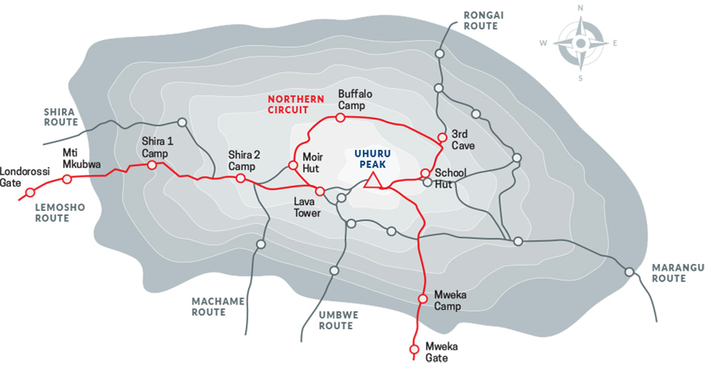
The Northern Circuit route is one of the best routes on Kilimanjaro, offering nearly 360 degrees of beautiful scenery including the quiet, rarely visited northern slopes.
As the longest Kilimanjaro route, the Northern Circuit also has the most acclimatization time and the highest summit success rate. Thus, the Northern Circuit route is highly recommended.
The route approaches Mount Kilimanjaro from the west, beginning with a long drive from Moshi to Londorossi Gate. From there, the first two days are spent trekking through the rainforest to Shira Ridge, before crossing the Shira Plateau. The route then heads north and circles clockwise from Moir Hut to Buffalo Camp to School Hut, before summiting from the east. Descend is made via the Mweka route.
Note that summit day on this path is tougher than other routes due to its longer distance.
Ultimate Kilimanjaro® offers the Northern Circuit as a 9 day group climb or as a 8 to 10 day private climb.
9 DAY NORTHERN CIRCUIT (STANDARD ROUTE)
The 9-Day Northern Circuit is the standard itinerary and our recommended version of this route. As the longest route on Kilimanjaro, it offers the most acclimatization time, the highest summit success rate, and nearly 360 degrees of scenery.
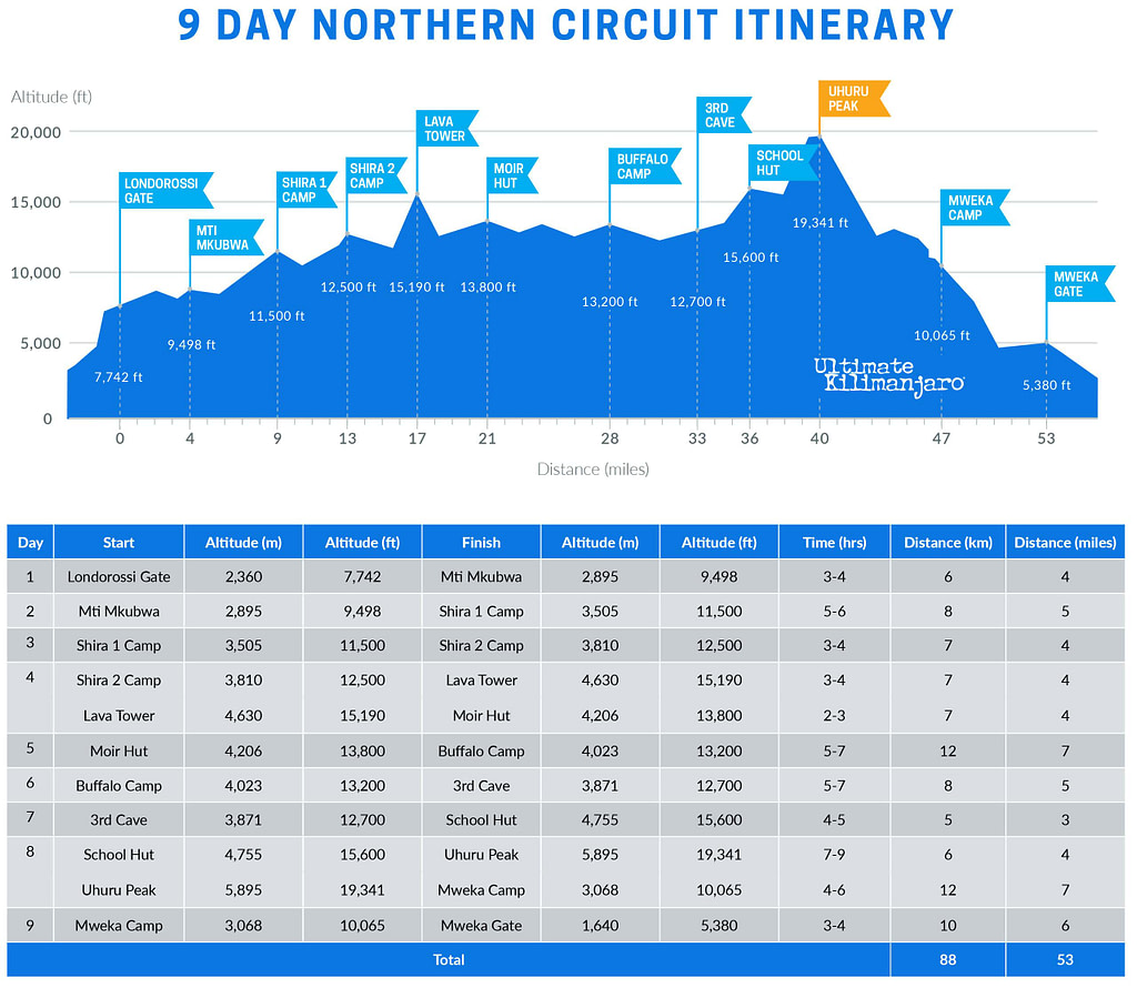
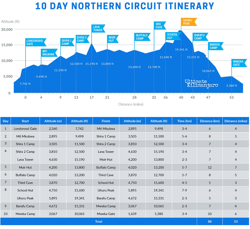
DAY 1 – Londorossi Gate to Mti Mkubwa
Elevation: 7,742 ft to 9,498 ft
Hiking Time: 3-4 hours
Distance: 6 km | 4 miles
Habitat: Rain Forest
We depart Moshi for Londorossi Gate, which takes about 4 hours, where you will complete entry formalities. Then drive to the Lemosho trailhead. Upon arrival at trailhead, we begin hiking through undisturbed forest which winds to the first camp site.
DAY 2 – Mti Mkubwa to Shira 1 Camp
We continue on the trail leading out of the rain forest and into a savannah of tall grasses, heather and volcanic rock draped with lichen beards. As we ascend through the lush rolling hills and cross several streams, we reach the Shira Ridge before dropping gently down to Shira 1 Camp. Here we catch our first glimpse of Kibo across the plateau.
DAY 3 – Shira 1 Camp to Shira 2 Camp
Elevation: 11,500 ft to 12,500 ft
Hiking Time: 3-4 hours
Distance: 7 km | 4 miles
Habitat: Heath
We explore the Shira Plateau. It is a gentle walk east on moorland meadows towards Shira 2 Camp. The heath zone displays abundant wildflowers and unique Senecio trees.
DAY 4 – Shira 2 Camp to Lava Tower to Moir Hut
Shira 2 Camp to Lava Tower
Elevation: 12,500 ft to 15,190 ft
Hiking Time: 3-4 hours
Lava Tower to Moir Hut
Elevation: 15,190 ft to 13,800 ft
Hiking Time: 2-3 hours
.
Distance: 7 km | 4 miles
Habitat: Alpine Desert
.
Distance: 7 km | 4 miles
Habitat: Alpine Desert
We continue to the east up a ridge and then head southeast towards the Lava Tower – a 300 ft tall volcanic rock formation. Then we divert from the main trail to Moir Hut, a little used site on the base of Lent Hills. A variety of walks are available on Lent Hills making this an excellent acclimatization opportunity. Shira Plateau is one of the highest plateaus on earth.
DAY 5 – Moir Hut to Buffalo Camp
Elevation: 13,800 ft to 13,200 ft
Hiking Time: 5-7 hours
Distance: 12 km | 7 miles
Habitat: Alpine Desert
We trek out of Moir Valley with a moderately steep climb, then hike to the summit of Lent Hills before returning to the main trail. The path crosses a rock field and gently undulates before reaching Buffalo Camp. This section of the trail offers great views across the plains that lie north of Kilimanjaro and stretch out to the Kenyan/Tanzanian border.
DAY 6 – Buffalo Camp to Third Cave
Elevation: 13,200 ft to 12,700 ft
Hiking Time: 5-7 hours
Distance: 8 km | 5 miles
Habitat: Heath
As we head up Buffalo Ridge, the terrain becomes increasingly sparse. This route is rarely travelled and we will enjoy its mountain wilderness feel. We trek through remote valleys on to the northern slopes of Kilimanjaro until we arrive at Third Cave.
DAY 7 – Third Cave to School Hut
Elevation: 12,700 ft to 15,600 ft
Hiking Time: 4-5 hours
Distance: 5 km | 3 miles
Habitat: Alpine Desert
We climb steadily up and over the “Saddle,” which sits between Kibo and Mawenzi. We continue on to our camp, School Hut. Once here we rest, enjoy an early dinner to prepare for the summit day.
DAY 8 – School Hut to Uhuru Peak to Mweka Camp
School Hut to Uhuru Peak
Elevation: 15,600 ft to 19,341 ft
Hiking Time: 7-9 hours
Uhuru Peak to Mweka Camp
Elevation: 19,341 ft to 10,065 ft
Hiking Time: 4-6 hours
.
Distance: 6 km | 4 miles
Habitat: Arctic
.
Distance: 12 km | 7 miles
Habitat: Rain Forest
Very early in the morning (around midnight), we begin our push to the summit. This is the most mentally and physically challenging portion of the trek. The wind and cold at this elevation and time of day can be extreme. We ascend in the darkness for several hours while taking frequent, but short, breaks. At Gilman’s point (18,600 ft), you will be rewarded with the most magnificent sunrise you are ever likely to see coming over Mawenzi Peak. Finally, we arrive at Uhuru Peak- the highest point on Mount Kilimanjaro and the continent of Africa.
From the summit, we make our descent to Mweka Camp, stopping at Barafu for lunch. The trail is very rocky and can be quite hard on the knees; trekking poles are helpful. Mweka Camp is situated in the upper forest and mist or rain can be expected in the late afternoon. Later in the evening, we enjoy our last dinner on the mountain and a well-earned sleep.
DAY 9 – Mweka Camp to Mweka Gate
Elevation: 10,065 ft to 5,380 ft
Hiking Time: 3-4 hours
Distance: 10 km | 6 miles
Habitat: Rain Forest
On our last day, we continue the descent to Mweka Gate. At lower elevations, it can be wet and muddy. A vehicle takes us back to the hotel in Moshi, where we receive our summit certificates.
8 DAY NORTHERN CIRCUIT
The 8-Day Northern Circuit is a shorter variation that reduces the itinerary by one day. It combines days 3 and 4 of the standard route, going from Shira 1 to Shira 2 to Moir Hut (skipping the detour to Lava Tower).
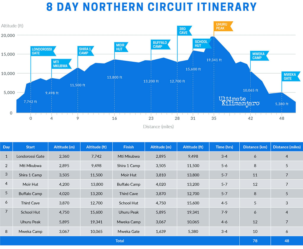
DAY 1 – Londorossi Gate to Mti Mkubwa
Elevation: 7,742 ft to 9,498 ft
Hiking Time: 3-4 hours
Distance: 6 km | 4 miles
Habitat: Rain Forest
We depart Moshi for Londorossi Gate, which takes about 4 hours, where you will complete entry formalities. Then drive to the Lemosho trailhead. Upon arrival at trailhead, we begin hiking through undisturbed forest which winds to the first camp site.
DAY 2 – Mti Mkubwa to Shira 1 Camp
Elevation: 9,498 ft to 11,500 ft
Hiking Time: 5-6 hours
Distance: 8 km | 5 miles
Habitat: Heath
We continue on the trail leading out of the rain forest and into a savannah of tall grasses, heather and volcanic rock draped with lichen beards. As we ascend through the lush rolling hills and cross several streams, we reach the Shira Ridge before dropping gently down to Shira 1 Camp. Here we catch our first glimpse of Kibo across the plateau.
DAY 3 – Shira 1 Camp to Moir Hut
Elevation: 11,500 ft to 13,800 ft
Hiking Time: 5-7 hours
Distance: 11 km | 7 miles
Habitat: Heath
We explore the Shira Plateau. It is a gentle walk east on moorland meadows towards Shira 2 Camp. The heath zone displays abundant wildflowers and unique Senecio trees. Then we divert from the main trail to Moir Hut, a little used site on the base of Lent Hills. A variety of walks are available on Lent Hills making this an excellent acclimatization opportunity. Shira Plateau is one of the highest plateaus on earth.
DAY 4 – Moir Hut to Buffalo Camp
Elevation: 13,800 ft to 13,200 ft
Hiking Time: 5-7 hours
Distance: 12 km | 7 miles
Habitat: Alpine Desert
We trek out of Moir Valley with a moderately steep climb, then hike to the summit of Lent Hills before returning to the main trail. The path crosses a rock field and gently undulates before reaching Buffalo Camp. This section of the trail offers great views across the plains that lie north of Kilimanjaro and stretch out to the Kenyan/Tanzanian border.
DAY 5 – Buffalo Camp to Third Cave
Elevation: 13,200 ft to 12,700 ft
Hiking Time: 5-7 hours
Distance: 8 km | 5 miles
Habitat: Heath
As we head up Buffalo Ridge, the terrain becomes increasingly sparse. This route is rarely travelled and we will enjoy its mountain wilderness feel. We trek through remote valleys on to the northern slopes of Kilimanjaro until we arrive at Third Cave.
DAY 6 – Third Cave to School Hut
Elevation: 12,700 ft to 15,600 ft
Hiking Time: 4-5 hours
Distance: 5 km | 3 miles
Habitat: Alpine Desert
We climb steadily up and over the “Saddle,” which sits between Kibo and Mawenzi. We continue on to our camp, School Hut. Once here we make camp, rest and enjoy dinner while preparing for the summit day.
DAY 7 – School Hut to Uhuru Peak to Mweka Camp
School Hut to Uhuru Peak
Elevation: 15,600 ft to 19,341 ft
Hiking Time: 7-9 hours
Uhuru Peak to Mweka Camp
Elevation: 19,341 ft to 10,065 ft
Hiking Time: 4-6 hours
.
Distance: 6 km | 4 miles
Habitat: Arctic
.
Distance: 12 km | 7 miles
Habitat: Rain Forest
Very early in the morning (around midnight), we begin our push to the summit. This is the most mentally and physically challenging portion of the trek. The wind and cold at this elevation and time of day can be extreme. We ascend in the darkness for several hours while taking frequent, but short, breaks. At Gilman’s point (18,600 ft), you will be rewarded with the most magnificent sunrise you are ever likely to see coming over Mawenzi Peak. Finally, we arrive at Uhuru Peak- the highest point on Mount Kilimanjaro and the continent of Africa.
From the summit, we make our descent to Mweka Camp, stopping at Barafu for lunch. The trail is very rocky and can be quite hard on the knees; trekking poles are helpful. Mweka Camp is situated in the upper forest and mist or rain can be expected in the late afternoon. Later in the evening, we enjoy our last dinner on the mountain and a well-earned sleep.
DAY 8 – Mweka Camp to Mweka Gate
Elevation: 10,065 ft to 5,380 ft
Hiking Time: 3-4 hours
Distance: 10 km | 6 miles
Habitat: Rain Forest
On our last day, we continue the descent to Mweka Gate. At lower elevations, it can be wet and muddy. A vehicle takes us back to the hotel in Moshi, where we receive our summit certificates.
9 DAY NORTHERN CIRCUIT (DAYTIME SUMMIT)
The 9-Day Northern Circuit (Daytime Summit) variation follows the 8-day Northern Circuit route, but replaces the traditional midnight summit with a daytime ascent. It avoids the extreme cold and windy nighttime conditions, while also shortening the duration of summit day. Thus, summit day is more comfortable and less physically demanding.
After summiting, climbers descend to Barafu Camp instead of Mweka Camp. This easier-paced descent adds one day to the itinerary.
Read more about Daytime Summit Routes.
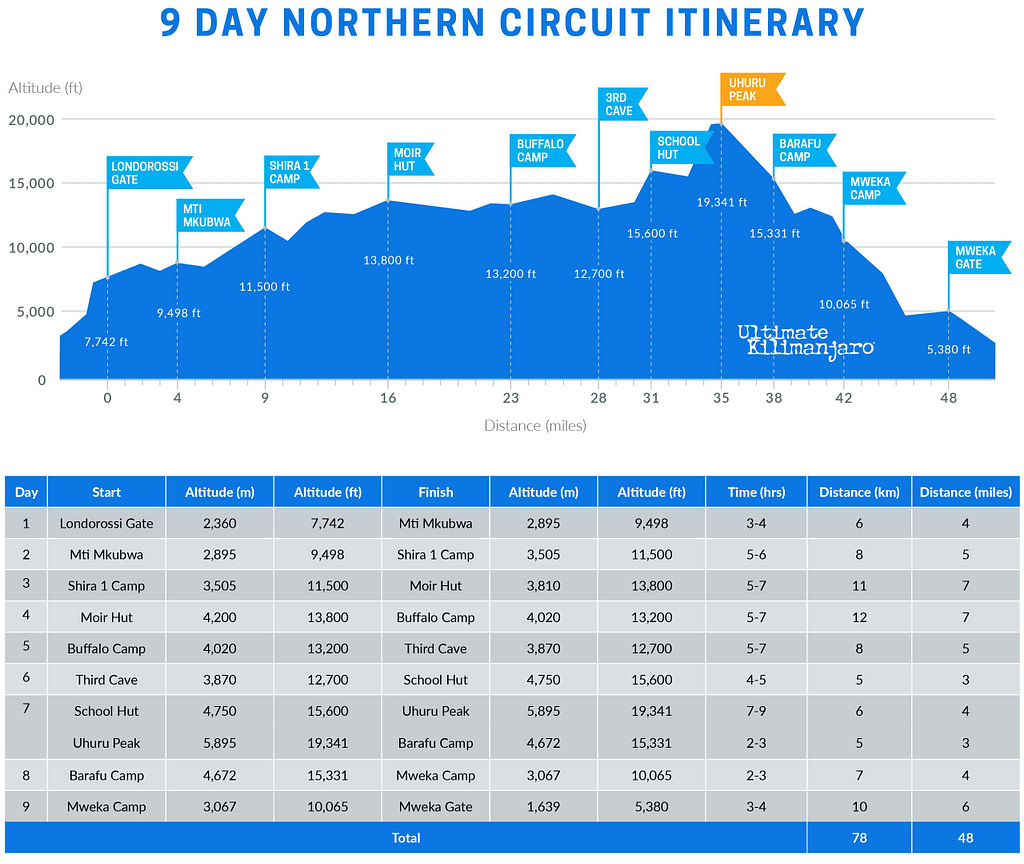
DAY 1 – Londorossi Gate to Mti Mkubwa
Elevation: 7,742 ft to 9,498 ft
Hiking Time: 3-4 hours
Distance: 6 km | 4 miles
Habitat: Rain Forest
We depart Moshi for Londorossi Gate, which takes about 4 hours, where you will complete entry formalities. Then drive to the Lemosho trailhead. Upon arrival at trailhead, we begin hiking through undisturbed forest which winds to the first camp site.
DAY 2 – Mti Mkubwa to Shira 1 Camp
Elevation: 9,498 ft to 11,500 ft
Hiking Time: 5-6 hours
Distance: 8 km | 5 miles
Habitat: Heath
We continue on the trail leading out of the rain forest and into a savannah of tall grasses, heather and volcanic rock draped with lichen beards. As we ascend through the lush rolling hills and cross several streams, we reach the Shira Ridge before dropping gently down to Shira 1 Camp. Here we catch our first glimpse of Kibo across the plateau.
DAY 3 – Shira 1 Camp to Moir Hut
Elevation: 11,500 ft to 13,800 ft
Hiking Time: 5-7 hours
Distance: 11 km | 7 miles
Habitat: Heath
We explore the Shira Plateau. It is a gentle walk east on moorland meadows towards Shira 2 Camp. The heath zone displays abundant wildflowers and unique Senecio trees. Then we divert from the main trail to Moir Hut, a little used site on the base of Lent Hills. A variety of walks are available on Lent Hills making this an excellent acclimatization opportunity. Shira Plateau is one of the highest plateaus on earth.
DAY 4 – Moir Hut to Buffalo Camp
Elevation: 13,800 ft to 13,200 ft
Hiking Time: 5-7 hours
Distance: 12 km | 7 miles
Habitat: Alpine Desert
We trek out of Moir Valley with a moderately steep climb, then hike to the summit of Lent Hills before returning to the main trail. The path crosses a rock field and gently undulates before reaching Buffalo Camp. This section of the trail offers great views across the plains that lie north of Kilimanjaro and stretch out to the Kenyan/Tanzanian border.
DAY 5 – Buffalo Camp to Third Cave
Elevation: 13,200 ft to 12,700 ft
Hiking Time: 5-7 hours
Distance: 8 km | 5 miles
Habitat: Heath
As we head up Buffalo Ridge, the terrain becomes increasingly sparse. This route is rarely travelled and we will enjoy its mountain wilderness feel. We trek through remote valleys on to the northern slopes of Kilimanjaro until we arrive at Third Cave.
DAY 6 – Third Cave to School Hut
Elevation: 12,700 ft to 15,600 ft
Hiking Time: 4-5 hours
Distance: 5 km | 3 miles
Habitat: Alpine Desert
We climb steadily up and over the “Saddle,” which sits between Kibo and Mawenzi. We continue on to our camp, School Hut. Once here we make camp, rest and enjoy dinner while preparing for the summit day.
DAY 7 – School Hut to Uhuru Peak to Barafu Camp
School Hut to Uhuru Peak
Elevation: 15,600 ft to 19,341 ft
Hiking Time: 7-9 hours
Uhuru Peak to Barafu Camp
Elevation: 19,341 ft to 15,331 ft
Hiking Time: 2-3 hours
.
Distance: 6 km | 4 miles
Habitat: Arctic
.
Distance: 5 km | 3 miles
Habitat: Alpine Desert
In the morning light, we begin our push to the summit. This is the most mentally and physically challenging portion of the trek. We ascend for several hours while taking frequent, but short, breaks. Upon reaching the crater rim, you arrive at Gilman’s point (18,600 ft), with the summit within striking distance. Finally, we arrive at Uhuru Peak – the highest point on Mount Kilimanjaro and the continent of Africa.
From the summit, we make our descent to Barafu Camp, where we celebrate our achievement and enjoy a well-earned sleep.
DAY 8 – Barafu Camp to Mweka Camp
Elevation: 15,331 ft to 10,065 ft
Hiking Time: 2-3 hours
Distance: 7 km | 4 miles
Habitat: Rain Forest
We make our descent going straight down to Mweka Camp, which is situated in the upper forest. The trail is very rocky and can be quite hard on the knees; trekking poles are helpful. Later in the evening, we have our last dinner on the mountain.
DAY 9 – Mweka Camp to Mweka Gate
Elevation: 10,065 ft to 5,380 ft
Hiking Time: 3-4 hours
Distance: 10 km | 6 miles
Habitat: Rain Forest
On our last day, we continue the descent to Mweka Gate. At lower elevations, it can be wet and muddy. A vehicle takes us back to the hotel in Moshi, where we receive our summit certificates.
10 DAY NORTHERN CIRCUIT (DAYTIME SUMMIT)
The 10-Day Northern Circuit (Daytime Summit) variation follows the 9-day Northern Circuit route, but replaces the traditional midnight summit with a daytime ascent. It avoids the extreme cold and windy nighttime conditions, while also shortening the duration of summit day. Thus, summit day is more comfortable and less physically demanding.
After summiting, climbers descend to Barafu Camp instead of Mweka Camp. This easier-paced descent adds one day to the itinerary.
Read more about Daytime Summit Routes.
DAY 1 – Londorossi Gate to Mti Mkubwa
Elevation: 7,742 ft to 9,498 ft
Hiking Time: 3-4 hours
Distance: 6 km | 4 miles
Habitat: Rain Forest
We depart Moshi for Londorossi Gate, which takes about 4 hours, where you will complete entry formalities. Then drive to the Lemosho trailhead. Upon arrival at trailhead, we begin hiking through undisturbed forest which winds to the first camp site.
DAY 2 – Mti Mkubwa to Shira 1 Camp
Elevation: 9,498 ft to 11,500 ft
Hiking Time: 5-6 hours
Distance: 8 km | 5 miles
Habitat: Heath
We continue on the trail leading out of the rain forest and into a savannah of tall grasses, heather and volcanic rock draped with lichen beards. As we ascend through the lush rolling hills and cross several streams, we reach the Shira Ridge before dropping gently down to Shira 1 Camp. Here we catch our first glimpse of Kibo across the plateau.
DAY 3 – Shira 1 Camp to Shira 2 Camp
Elevation: 11,500 ft to 12,500 ft
Hiking Time: 3-4 hours
Distance: 7 km | 4 miles
Habitat: Heath
We explore the Shira Plateau. It is a gentle walk east on moorland meadows towards Shira 2 Camp. The heath zone displays abundant wildflowers and unique Senecio trees.
DAY 4 – Shira 2 Camp to Lava Tower to Moir Hut
Shira 2 Camp to Lava Tower
Elevation: 12,500 ft to 15,190 ft
Hiking Time: 3-4 hours
Lava Tower to Moir Hut
Elevation: 15,190 ft to 13,800 ft
Hiking Time: 2-3 hours
.
Distance: 7 km | 4 miles
Habitat: Alpine Desert
.
Distance: 7 km | 4 miles
Habitat: Alpine Desert
We continue to the east up a ridge and then head southeast towards the Lava Tower – a 300 ft tall volcanic rock formation. Then we divert from the main trail to Moir Hut, a little used site on the base of Lent Hills. A variety of walks are available on Lent Hills making this an excellent acclimatization opportunity. Shira Plateau is one of the highest plateaus on earth.
DAY 5 – Moir Hut to Buffalo Camp
Elevation: 13,800 ft to 13,200 ft
Hiking Time: 5-7 hours
Distance: 12 km | 7 miles
Habitat: Alpine Desert
We trek out of Moir Valley with a moderately steep climb, then hike to the summit of Lent Hills before returning to the main trail. The path crosses a rock field and gently undulates before reaching Buffalo Camp. This section of the trail offers great views across the plains that lie north of Kilimanjaro and stretch out to the Kenyan/Tanzanian border.
DAY 6 – Buffalo Camp to Third Cave
Elevation: 13,200 ft to 12,700 ft
Hiking Time: 5-7 hours
Distance: 8 km | 5 miles
Habitat: Heath
As we head up Buffalo Ridge, the terrain becomes increasingly sparse. This route is rarely travelled and we will enjoy its mountain wilderness feel. We trek through remote valleys on to the northern slopes of Kilimanjaro until we arrive at Third Cave.
DAY 7 – Third Cave to School Hut
Elevation: 12,700 ft to 15,600 ft
Hiking Time: 4-5 hours
Distance: 5 km | 3 miles
Habitat: Alpine Desert
We climb steadily up and over the “Saddle,” which sits between Kibo and Mawenzi. We continue on to our camp, School Hut. Once here we rest, enjoy an early dinner to prepare for the summit day.
DAY 8 – School Hut to Uhuru Peak to Barafu Camp
School Hut to Uhuru Peak
Elevation: 15,600 ft to 19,341 ft
Hiking Time: 7-9 hours
Uhuru Peak to Barafu Camp
Elevation: 19,341 ft to 15,331 ft
Hiking Time: 2-3 hours
.
Distance: 6 km | 4 miles
Habitat: Arctic
.
Distance: 5 km | 3 miles
Habitat: Alpine Desert
In the morning light, we begin our push to the summit. This is the most mentally and physically challenging portion of the trek. We ascend for several hours while taking frequent, but short, breaks. Upon reaching the crater rim, you arrive at Gilman’s point (18,600 ft), with the summit within striking distance. Finally, we arrive at Uhuru Peak – the highest point on Mount Kilimanjaro and the continent of Africa.
From the summit, we make our descent to Barafu Camp, where we celebrate our achievement and enjoy a well-earned sleep.
DAY 9 – Barafu Camp to Mweka Camp
Elevation: 15,331 ft to 10,065 ft
Hiking Time: 2-3 hours
Distance: 7 km | 6 miles
Habitat: Rain Forest
We make our descent going straight down to Mweka Camp, which is situated in the upper forest. The trail is very rocky and can be quite hard on the knees; trekking poles are helpful. Later in the evening, we have our last dinner on the mountain.
DAY 10 – Mweka Camp to Mweka Gate
Elevation: 10,065 ft to 5,380 ft
Hiking Time: 3-4 hours
Distance: 10 km | 6 miles
Habitat: Rain Forest
On our last day, we continue the descent to Mweka Gate. At lower elevations, it can be wet and muddy. A vehicle takes us back to the hotel in Moshi, where we receive our summit certificates.
10 DAY NORTHERN CRATER
The 10-Day Northern Crater variation follows the 9-day Northern Circuit route, but includes an overnight stay at Crater Camp. This campsite, located just below the summit, is within the volcanic crater itself. It is the most extreme and exclusive campsite on Mount Kilimanjaro, allowing for exploration of Furtwangler Glacier and the Ash Pit.
Due to the added risk of sleeping at extreme altitude, this route is available as a private climb by special request.
Read more about Crater Camp.
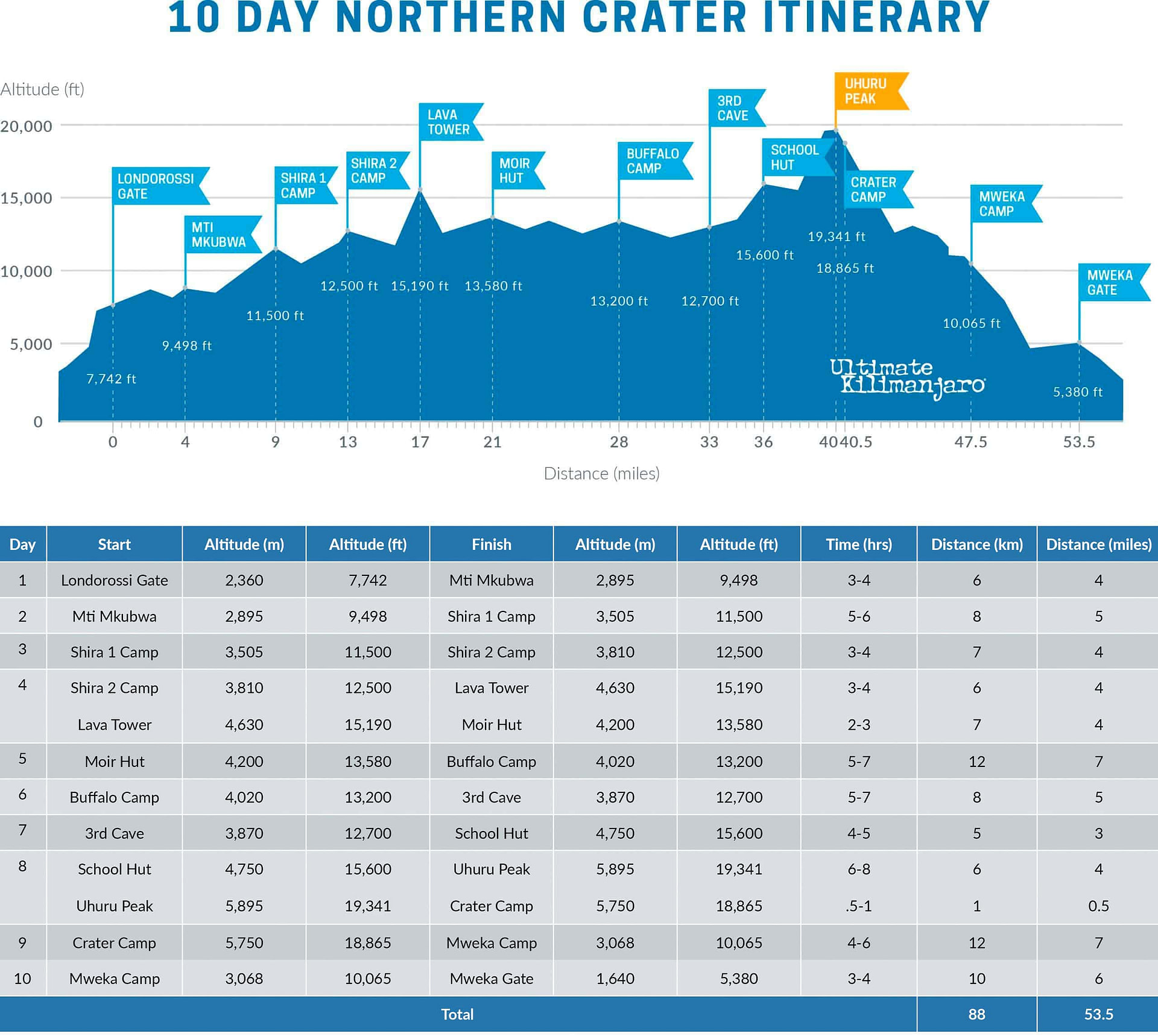
DAY 1 – Londorossi Gate to Mti Mkubwa
Elevation: 7,742 ft to 9,498 ft
Hiking Time: 3-4 hours
Distance: 6 km | 4 miles
Habitat: Rain Forest
We depart Moshi for Londorossi Gate, which takes about 4 hours, where you will complete entry formalities. Then drive to the Lemosho trailhead. Upon arrival at trailhead, we begin hiking through undisturbed forest which winds to the first camp site.
DAY 2 – Mti Mkubwa to Shira 1 Camp
Elevation: 9,498 ft to 11,500 ft
Hiking Time: 5-6 hours
Distance: 8 km | 5 miles
Habitat: Heath
We continue on the trail leading out of the rain forest and into a savannah of tall grasses, heather and volcanic rock draped with lichen beards. As we ascend through the lush rolling hills and cross several streams, we reach the Shira Ridge before dropping gently down to Shira 1 Camp. Here we catch our first glimpse of Kibo across the plateau.
DAY 3 – Shira 1 Camp to Shira 2 Camp
Elevation: 11,500 ft to 12,500 ft
Hiking Time: 3-4 hours
Distance: 7 km | 4 miles
Habitat: Heath
We explore the Shira Plateau. It is a gentle walk east on moorland meadows towards Shira 2 Camp. The heath zone displays abundant wildflowers and unique Senecio trees.
DAY 4 – Shira 2 Camp to Lava Tower to Moir Hut
Shira 2 Camp to Lava Tower
Elevation: 12,500 ft to 15,190 ft
Hiking Time: 3-4 hours
Lava Tower to Moir Hut
Elevation: 15,190 ft to 13,800 ft
Hiking Time: 2-3 hours
.
Distance: 7 km | 4 miles
Habitat: Alpine Desert
.
Distance: 7 km | 4 miles
Habitat: Alpine Desert
We continue to the east up a ridge and then head southeast towards the Lava Tower – a 300 ft tall volcanic rock formation. Then we divert from the main trail to Moir Hut, a little used site on the base of Lent Hills. A variety of walks are available on Lent Hills making this an excellent acclimatization opportunity. Shira Plateau is one of the highest plateaus on earth.
DAY 5 – Moir Hut to Buffalo Camp
Elevation: 13,800 ft to 13,200 ft
Hiking Time: 5-7 hours
Distance: 12 km | 7 miles
Habitat: Alpine Desert
We trek out of Moir Valley with a moderately steep climb, then hike to the summit of Lent Hills before returning to the main trail. The path crosses a rock field and gently undulates before reaching Buffalo Camp. This section of the trail offers great views across the plains that lie north of Kilimanjaro and stretch out to the Kenyan/Tanzanian border.
DAY 6 – Buffalo Camp to Third Cave
Elevation: 13,200 ft to 12,700 ft
Hiking Time: 5-7 hours
Distance: 8 km | 5 miles
Habitat: Heath
As we head up Buffalo Ridge, the terrain becomes increasingly sparse. This route is rarely travelled and we will enjoy its mountain wilderness feel. We trek through remote valleys on to the northern slopes of Kilimanjaro until we arrive at Third Cave.
DAY 7 – Third Cave to School Hut
Elevation: 12,700 ft to 15,600 ft
Hiking Time: 4-5 hours
Distance: 5 km | 3 miles
Habitat: Alpine Desert
We climb steadily up and over the “Saddle,” which sits between Kibo and Mawenzi. We continue on to our camp, School Hut. Once here we rest, enjoy dinner and prepare for the summit day.
DAY 8 – School Hut to Uhuru Peak to Crater Camp
School Hut to Uhuru Peak
Elevation: 15,600 ft to 19,341 ft
Hiking Time: 6-8 hours
Uhuru Peak to Crater Camp
Elevation: 19,341 ft to 18,865 ft
Hiking Time: 0.5-1 hours
.
Distance: 6 km | 4 miles
Habitat: Arctic
.
Distance: 1 km | 0.6 miles
Habitat: Arctic
During normal morning hours, we begin our push to the summit. This is the most mentally and physically challenging portion of the trek. We ascend for several hours at a slow but steady pace while taking frequent, but short, breaks. The trail turns into heavy scree as we make the steep climb to the crater rim. At Gilman’s Point (18,600 ft), we see the summit sign in the distance. We continue the around the crater rim until finally we arrive at Uhuru Peak- the highest point on Mount Kilimanjaro and the continent of Africa.
We then descend a short distance to Crater Camp, where the rest of the staff will join us to set up camp. There is an option to hike to Reusch Crater and the ash pit, or simply explore the areas around Furtwangler Glacier. Sleeping at this high altitude can be dangerous. Serious AMS can develop if adequate altitude acclimatization has not been achieved so the guides will monitor you very closely.
DAY 9 – Crater Camp to Mweka Camp
Elevation: 18,865 ft to 10,065 ft
Hiking Time: 4-6 hours
Distance: 12 km | 7 miles
Habitat: Artic
From Crater Camp, we now make our descent continuing straight down to the Mweka Hut camp site, stopping at Barafu for lunch. The trail is very rocky and can be quite hard on the knees; trekking poles are helpful. Mweka Camp is situated in the upper forest and mist or rain can be expected in the late afternoon. Later in the evening, we enjoy our last dinner on the mountain and a well-earned sleep.
DAY 10 – Mweka Camp to Mweka Gate
Elevation: 10,065 ft to 5,380 ft
Hiking Time: 3-4 hours
Distance: 10 km | 6 miles
Habitat: Rain Forest
On our last day, we continue the descent to Mweka Gate and collect the summit certificates. At lower elevations, it can be wet and muddy. From the gate, we continue another hour to Mweka Village. A vehicle will meet us at Mweka Village to drive us back to the hotel in Moshi.
ROUTE FAQs
How Long is the Northern Circuit Route?
The distance of the Northern Circuit route is approximately 88 km or 53 miles.
How Many Days Does it Take to Climb Kilimanjaro on the Northern Circuit Route?
The Northern Circuit route has several variations and thus, the trail can be completed in as little as 8 days and as many as 10 days. The standard itinerary is the preferred variation which requires 9 days.
How Hard is Climbing Kilimanjaro on the Northern Circuit Route?
The Northern Circuit route is considered a difficult route due to its up and down nature. The long time spent on the mountain means climbers have a great chance of acclimatizing to the altitude. However, this duration on the mountain also has its drawbacks. It can cause general fatigue, sleep deprivation, digestive problems, respiratory issues, and other illnesses. Additionally, summit day is particularly challenging because climbers must travel a longer distance compared to other routes.
What is the Success Rate of Climbing Kilimanjaro on the Northern Circuit Route?
The success rate depends on the number of days you spend on the mountain. Our success rate for 8 day Northern Circuit is about 90-95%. Our success rate for the 9 and 10 day Northern Circuit route is about 95-98%.
How Much Does it Cost to Climb Kilimanjaro on the Northern Circuit Route?
The cost of the Northern Circuit route will vary depending on the guide service. See our prices here.
See our epic feature film where an Ultimate Kilimanjaro® group tackles the 9 day Northern route.
